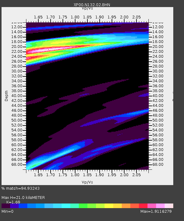
N132 N132 - Earthquake Result Viewer

Earthquake location: South Sandwich Islands Region
Earthquake latitude/longitude: -57.0/-24.8
Earthquake time(UTC): 2002/12/17 (351) 04:32:53 GMT
Earthquake Depth: 10 km
Earthquake Magnitude: 5.4 MB, 6.3 MS, 6.2 MW, 6.0 MW
Earthquake Catalog/Contributor: WHDF/NEIC
Network: XP Trans Antarctic Mountain Seismic Experiment
Station: N132 N132
Lat/Lon: 82.08 S/101.96 E
Elevation: 3419 m
Distance: 38.5 deg
Az: 169.708 deg
Baz: 224.86 deg
Ray Param: 0.075541966
Estimated Moho Depth: 21.0 km
Estimated Crust Vp/Vs: 1.69
Assumed Crust Vp: 6.261 km/s
Estimated Crust Vs: 3.705 km/s
Estimated Crust Poisson's Ratio: 0.23
Radial Match: 94.93243 %
Radial Bump: 400
Transverse Match: 89.7667 %
Transverse Bump: 400
SOD ConfigId: 16820
Insert Time: 2010-03-09 13:45:11.401 +0000
GWidth: 2.5
Max Bumps: 400
Tol: 0.001

Signal To Noise

ChannelStoNSTALTA
XP:N132:02:BHN:20021217T04:39:44.295006Z4.3825974.3515126E-79.929074E-8
XP:N132:02:BHE:20021217T04:39:44.295006Z4.4911755.039114E-71.1220034E-7
XP:N132:02:BHZ:20021217T04:39:44.295006Z9.7265521.5620786E-61.6059943E-7
Arrivals
Ps2.5 SECOND
PpPs8.4 SECOND
PsPs/PpSs11 SECOND