
Station XP N132 - N132
Network: XP00 - Trans Antarctic Mountain Seismic Experiment
Nearby stations (2 deg radius)
| Station | Name | (Lat, Lon) | Start / End | Elevation |
| N132 | N132 | (-82.08, 101.96) | 2001-12-05 / 2003-12-31 | 3.4 km |
| Crust2 Type: | F7,Archean 3.0 km ice, no seds. |
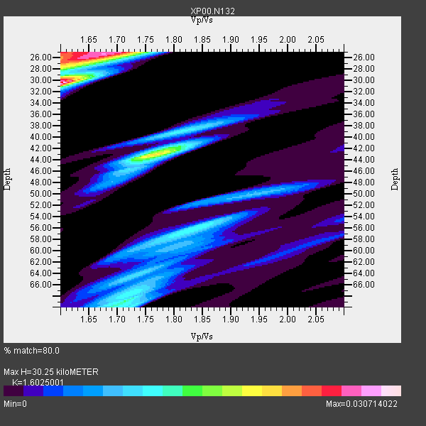
| Thickness Estimate: | 30 km |
| Thickness StdDev: | 4.4 km |
| Vp/Vs Estimate: | 1.60 |
| Vp/Vs StdDev: | 0.02 |
| Vs Estimate: | 3.907 km/s |
| Poisson's Ratio: | 0.18 |
| Peak Value: | 0.03 |
| Assumed Vp: | 6.261 km/s |
| Ps Weight: | 0.33333334 |
| PpPs Weight: | 0.33333334 |
| PsPs Weight: | 0.33333328 |
| Residual Complexity: | 0.899 |
| Nearby stations H: | +- |
| (2.0 deg) Vp/Vs: | +- |
5 with match > 90% ( 71.42857 %) and 7 with match > 80% ( 100.0 %) out of 7.
Download stack as xyz text file.
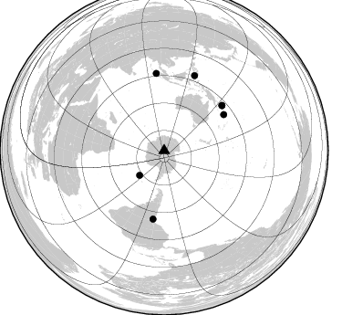
Azimuth Distribution of Events:
Prior Results for this Station
| Study | Thickness | Vp/Vs | Vp | Vs | Poissons Ratio | Extra |
| EARS | 30 km | 1.60 | 6.261 km/s | 3.907 km/s | 0.18 | |
| Crust2.0 | 40 km | 1.77 | 6.261 km/s | 3.535 km/s | 0.27 | F7,Archean 3.0 km ice, no seds. |
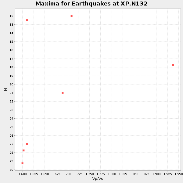
| Global Maxima | 30 km | 1.60 | 6.261 km/s | 3.907 km/s | 0.18 | amp=0.030714022 |
| Local Maxima 1 | 25 km | 1.68 | 6.261 km/s | 3.738 km/s | 0.22 | amp=0.026937773 |
| Local Maxima 2 | 43 km | 1.76 | 6.261 km/s | 3.552 km/s | 0.26 | amp=0.020958733 |
| Local Maxima 3 | 25 km | 1.60 | 6.261 km/s | 3.913 km/s | 0.18 | amp=0.018634388 |
| Local Maxima 4 | 69 km | 1.71 | 6.261 km/s | 3.656 km/s | 0.24 | amp=0.013902537 |
| Predicted Arrivals for vertical incidence (zero ray parameter) | |
| Ps | 2.91 SECOND |
| PpPs | 12.57 SECOND |
| PsPs/PpSs | 15.49 SECOND |
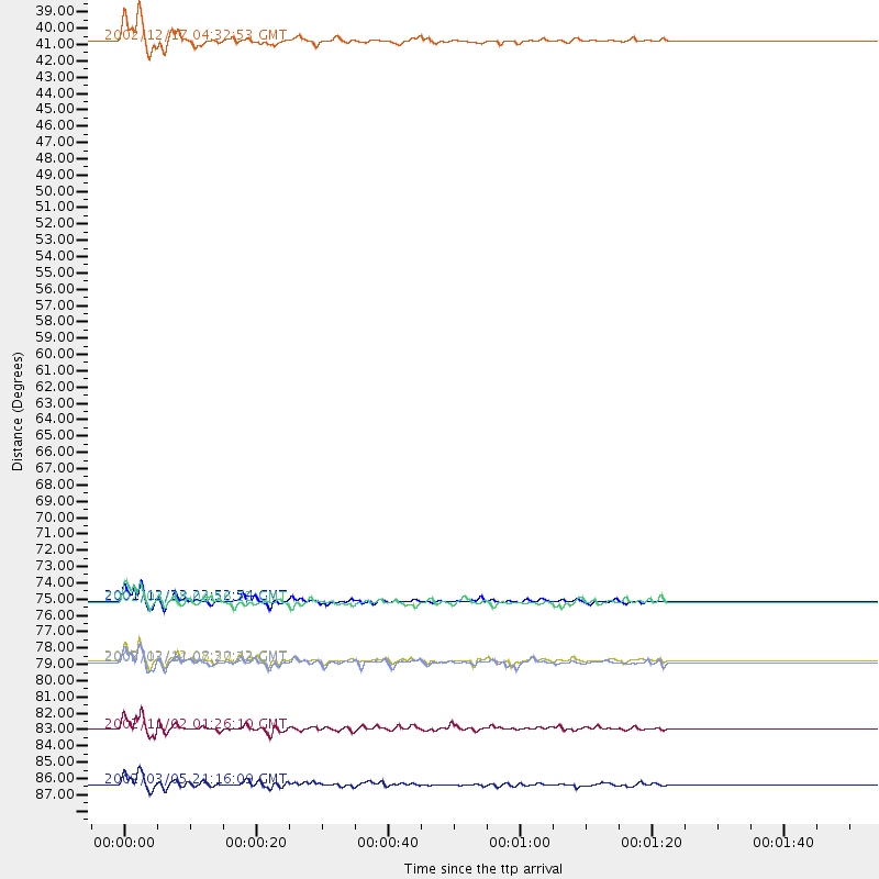
Events Processed for this Station
Download zip of receiver functions as SAC
Plot maxima for each earthquake.
Events Used in the Stack
(7 events)| Radial Match | Distance | Baz | FERegion | Time | Lat/Lon | Depth | Magnitude |
| 96.442184 | 76.3 deg | 58.976 deg | Solomon Islands | 2001/12/23 22:52:54 GMT | (-9.6, 159.5) | 16 km | 6.2 MB, 7.0 MS, 6.8 MW, 6.7 MW |
| 96.43974 | 80.3 deg | 52.115 deg | New Ireland Region, P.N.G. | 2002/12/12 08:30:42 GMT | (-4.8, 153.3) | 34 km | 5.9 MB, 6.7 MS, 6.7 MW, 6.6 MW |
| 95.9882 | 84.9 deg | 354.113 deg | Northern Sumatra, Indonesia | 2002/11/02 01:26:10 GMT | (2.8, 96.1) | 30 km | 6.2 MB, 7.6 MS, 7.4 MW, 7.4 MW |
| 94.93243 | 38.5 deg | 224.86 deg | South Sandwich Islands Region | 2002/12/17 04:32:53 GMT | (-57.0, -24.8) | 10 km | 5.4 MB, 6.3 MS, 6.2 MW, 6.0 MW |
| 93.01686 | 88.6 deg | 22.172 deg | Mindanao, Philippines | 2002/03/05 21:16:09 GMT | (6.0, 124.2) | 31 km | 6.3 MB, 7.2 MS, 7.5 MW, 7.2 MW |
| 86.223755 | 80.4 deg | 52.067 deg | New Ireland Region, P.N.G. | 2003/03/11 07:27:32 GMT | (-4.7, 153.2) | 40 km | 6.0 MB, 6.8 MS, 6.8 MW, 6.6 MW |
| 80.41889 | 76.3 deg | 189.297 deg | Chile-Bolivia Border Region | 2002/03/28 04:56:22 GMT | (-21.7, -68.3) | 125 km | 6.1 MB, 6.5 MW, 6.5 MW |
Losers
(0 events)| Radial Match | Distance | Baz | FERegion | Time | Lat/Lon | Depth | Magnitude | Reason |
