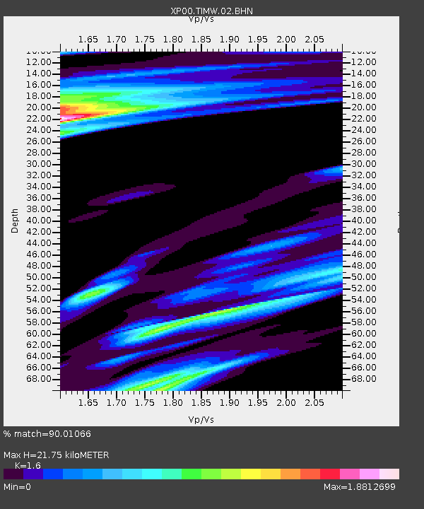
TIMW TIMW - Earthquake Result Viewer

Earthquake location: Mindanao, Philippines
Earthquake latitude/longitude: 7.5/123.4
Earthquake time(UTC): 2002/12/30 (364) 04:49:08 GMT
Earthquake Depth: 10 km
Earthquake Magnitude: 5.9 MB, 6.2 MS, 6.3 MW, 6.2 MW
Earthquake Catalog/Contributor: WHDF/NEIC
Network: XP Trans Antarctic Mountain Seismic Experiment
Station: TIMW TIMW
Lat/Lon: 80.39 S/135.27 E
Elevation: 2496 m
Distance: 88.0 deg
Az: 178.019 deg
Baz: 348.231 deg
Ray Param: 0.04294698
Estimated Moho Depth: 21.75 km
Estimated Crust Vp/Vs: 1.60
Assumed Crust Vp: 6.292 km/s
Estimated Crust Vs: 3.932 km/s
Estimated Crust Poisson's Ratio: 0.18
Radial Match: 90.01066 %
Radial Bump: 400
Transverse Match: 78.80969 %
Transverse Bump: 400
SOD ConfigId: 16820
Insert Time: 2010-03-09 13:45:22.227 +0000
GWidth: 2.5
Max Bumps: 400
Tol: 0.001

Signal To Noise

ChannelStoNSTALTA
XP:TIMW:02:BHN:20021230T05:01:27.12103Z2.11643272.1713689E-71.025957E-7
XP:TIMW:02:BHE:20021230T05:01:27.12103Z1.00912969.610003E-89.523061E-8
XP:TIMW:02:BHZ:20021230T05:01:27.12103Z3.51805541.5173492E-74.3130342E-8
Arrivals
Ps2.1 SECOND
PpPs8.8 SECOND
PsPs/PpSs11 SECOND