
Station XP TIMW - TIMW
Network: XP00 - Trans Antarctic Mountain Seismic Experiment
Nearby stations (2 deg radius)
| Station | Name | (Lat, Lon) | Start / End | Elevation |
| TIMW | TIMW | (-80.39, 135.27) | 2001-12-08 / 2003-12-31 | 2.5 km |
| Crust2 Type: | F6,Archean 2.5 km ice, no seds. |
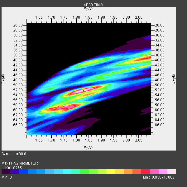
| Thickness Estimate: | 52 km |
| Thickness StdDev: | 8.7 km |
| Vp/Vs Estimate: | 1.83 |
| Vp/Vs StdDev: | 0.14 |
| Vs Estimate: | 3.443 km/s |
| Poisson's Ratio: | 0.29 |
| Peak Value: | 0.04 |
| Assumed Vp: | 6.292 km/s |
| Ps Weight: | 0.33333334 |
| PpPs Weight: | 0.33333334 |
| PsPs Weight: | 0.33333328 |
| Residual Complexity: | 0.779 |
| Nearby stations H: | +- |
| (2.0 deg) Vp/Vs: | +- |
6 with match > 90% ( 75.0 %) and 8 with match > 80% ( 100.0 %) out of 8.
Download stack as xyz text file.
Azimuth Distribution of Events:

Prior Results for this Station
| Study | Thickness | Vp/Vs | Vp | Vs | Poissons Ratio | Extra |
| EARS | 52 km | 1.83 | 6.292 km/s | 3.443 km/s | 0.29 | |
| Crust2.0 | 40 km | 1.77 | 6.292 km/s | 3.556 km/s | 0.27 | F6,Archean 2.5 km ice, no seds. |
| Global Maxima | 52 km | 1.83 | 6.292 km/s | 3.443 km/s | 0.29 | amp=0.036717802 |
| Local Maxima 1 | 39 km | 2.09 | 6.292 km/s | 3.014 km/s | 0.35 | amp=0.02979782 |
| Local Maxima 2 | 59 km | 1.78 | 6.292 km/s | 3.53 km/s | 0.27 | amp=0.029407933 |
| Local Maxima 3 | 59 km | 1.70 | 6.292 km/s | 3.712 km/s | 0.23 | amp=0.026284602 |
| Local Maxima 4 | 40 km | 1.86 | 6.292 km/s | 3.392 km/s | 0.30 | amp=0.021253778 |
| Predicted Arrivals for vertical incidence (zero ray parameter) | |
| Ps | 6.84 SECOND |
| PpPs | 23.37 SECOND |
| PsPs/PpSs | 30.21 SECOND |
Events Processed for this Station
Download zip of receiver functions as SAC
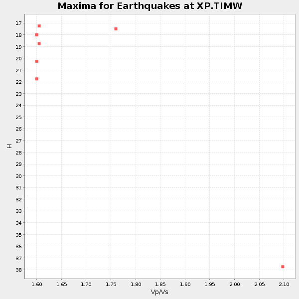
Plot maxima for each earthquake.
Events Used in the Stack
(8 events)| Radial Match | Distance | Baz | FERegion | Time | Lat/Lon | Depth | Magnitude |
| 98.14593 | 70.9 deg | 26.623 deg | Solomon Islands | 2003/01/20 08:43:06 GMT | (-10.5, 160.8) | 33 km | 6.7 MB, 7.8 MS, 7.3 MW, 7.2 MW |
| 95.98567 | 42.4 deg | 196.051 deg | South Sandwich Islands Region | 2002/12/17 04:32:53 GMT | (-57.0, -24.8) | 10 km | 5.4 MB, 6.3 MS, 6.2 MW, 6.0 MW |
| 94.64475 | 46.6 deg | 250.532 deg | Prince Edward Islands Region | 2003/01/27 17:56:25 GMT | (-46.0, 35.1) | 10 km | 5.6 MB, 6.3 MS, 6.5 MW, 6.4 MW |
| 93.51034 | 86.5 deg | 349.02 deg | Mindanao, Philippines | 2002/03/05 21:16:09 GMT | (6.0, 124.2) | 31 km | 6.3 MB, 7.2 MS, 7.5 MW, 7.2 MW |
| 91.353485 | 77.5 deg | 12.967 deg | Bismarck Sea | 2002/12/20 14:14:42 GMT | (-3.1, 147.9) | 33 km | 5.8 MB, 6.4 MS, 6.3 MW, 6.3 MW |
| 90.01066 | 88.0 deg | 348.231 deg | Mindanao, Philippines | 2002/12/30 04:49:08 GMT | (7.5, 123.4) | 10 km | 5.9 MB, 6.2 MS, 6.3 MW, 6.2 MW |
| 89.96024 | 53.6 deg | 51.438 deg | Kermadec Islands, New Zealand | 2001/12/25 23:00:46 GMT | (-30.2, -178.1) | 57 km | 5.4 MB, 5.9 MW, 5.8 MW |
| 80.11848 | 86.7 deg | 350.423 deg | Mindanao, Philippines | 2002/01/01 11:29:22 GMT | (6.3, 125.7) | 138 km | 5.9 MB, 6.3 MW, 6.3 MW |
Losers
(0 events)| Radial Match | Distance | Baz | FERegion | Time | Lat/Lon | Depth | Magnitude | Reason |
