You are here: Home > Network List > IC - New China Digital Seismograph Network Stations List
> Station HIA Hailar, Neimenggu Autonomous Region, China > Earthquake Result Viewer
HIA Hailar, Neimenggu Autonomous Region, China - Earthquake Result Viewer
| Earthquake location: |
Solomon Islands |
| Earthquake latitude/longitude: |
-8.9/158.5 |
| Earthquake time(UTC): |
2021/10/15 (288) 02:44:57 GMT |
| Earthquake Depth: |
23 km |
| Earthquake Magnitude: |
6.4 mww |
| Earthquake Catalog/Contributor: |
NEIC PDE/us |
|
| Network: |
IC New China Digital Seismograph Network |
| Station: |
HIA Hailar, Neimenggu Autonomous Region, China |
| Lat/Lon: |
49.27 N/119.74 E |
| Elevation: |
620 m |
|
| Distance: |
67.1 deg |
| Az: |
333.58 deg |
| Baz: |
137.835 deg |
| Ray Param: |
0.057145104 |
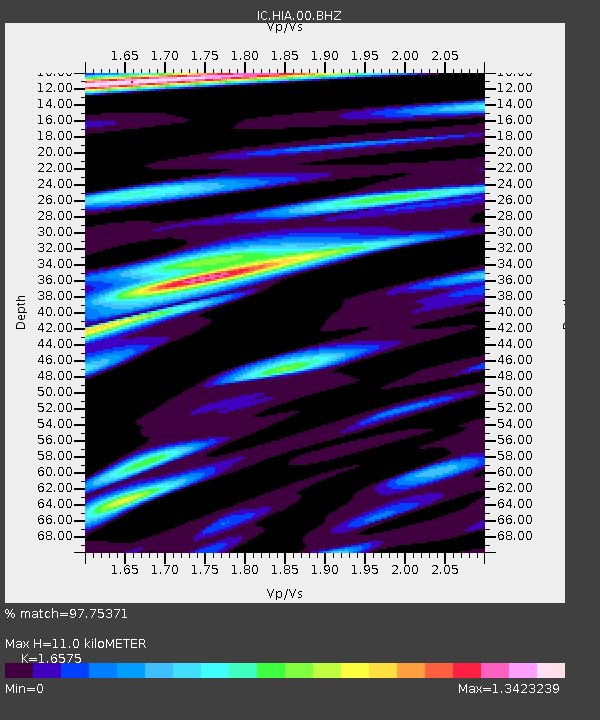
| Estimated Moho Depth: |
11.0 km |
| Estimated Crust Vp/Vs: |
1.66 |
| Assumed Crust Vp: |
6.577 km/s |
| Estimated Crust Vs: |
3.968 km/s |
| Estimated Crust Poisson's Ratio: |
0.21 |
|
| Radial Match: |
97.75371 % |
| Radial Bump: |
400 |
| Transverse Match: |
89.73964 % |
| Transverse Bump: |
400 |
| SOD ConfigId: |
26497111 |
| Insert Time: |
2021-10-29 02:57:16.433 +0000 |
| GWidth: |
2.5 |
| Max Bumps: |
400 |
| Tol: |
0.001 |
|

Signal To Noise
| Channel | StoN | STA | LTA |
| IC:HIA:00:BHZ:20211015T02:55:18.518999Z | 23.095026 | 1.5048363E-6 | 6.515846E-8 |
| IC:HIA:00:BH1:20211015T02:55:18.518999Z | 9.047928 | 6.196289E-7 | 6.848297E-8 |
| IC:HIA:00:BH2:20211015T02:55:18.518999Z | 6.8716326 | 4.5485956E-7 | 6.619381E-8 |
| Arrivals |
| Ps | 1.2 SECOND |
| PpPs | 4.3 SECOND |
| PsPs/PpSs | 5.4 SECOND |


