You are here: Home > Network List > IC - New China Digital Seismograph Network Stations List
> Station HIA Hailar, Neimenggu Autonomous Region, China > Earthquake Result Viewer
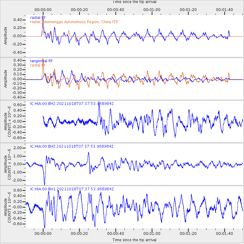
HIA Hailar, Neimenggu Autonomous Region, China - Earthquake Result Viewer
*The percent match for this event was below the threshold and hence no stack was calculated.
| Earthquake location: |
Vanuatu Islands |
| Earthquake latitude/longitude: |
-13.7/166.9 |
| Earthquake time(UTC): |
2021/10/18 (291) 07:26:52 GMT |
| Earthquake Depth: |
96 km |
| Earthquake Magnitude: |
6.1 Mww |
| Earthquake Catalog/Contributor: |
NEIC PDE/us |
|
| Network: |
IC New China Digital Seismograph Network |
| Station: |
HIA Hailar, Neimenggu Autonomous Region, China |
| Lat/Lon: |
49.27 N/119.74 E |
| Elevation: |
620 m |
|
| Distance: |
75.3 deg |
| Az: |
330.205 deg |
| Baz: |
132.507 deg |
| Ray Param: |
$rayparam |
*The percent match for this event was below the threshold and hence was not used in the summary stack. |
|
| Radial Match: |
77.02885 % |
| Radial Bump: |
366 |
| Transverse Match: |
54.219246 % |
| Transverse Bump: |
323 |
| SOD ConfigId: |
26497111 |
| Insert Time: |
2021-11-01 07:39:24.644 +0000 |
| GWidth: |
2.5 |
| Max Bumps: |
400 |
| Tol: |
0.001 |
|
Signal To Noise
| Channel | StoN | STA | LTA |
| IC:HIA:00:BHZ:20211018T07:37:53.968984Z | 7.04944 | 9.78638E-7 | 1.3882493E-7 |
| IC:HIA:00:BH1:20211018T07:37:53.968984Z | 2.0881846 | 3.2283572E-7 | 1.5460114E-7 |
| IC:HIA:00:BH2:20211018T07:37:53.968984Z | 3.3153238 | 2.7126165E-7 | 8.182056E-8 |
| Arrivals |
| Ps | |
| PpPs | |
| PsPs/PpSs | |


