You are here: Home > Network List > GY - Geyokcha, Turkmenistan Seismic Array Stations List
> Station G22 GY.G22 > Earthquake Result Viewer
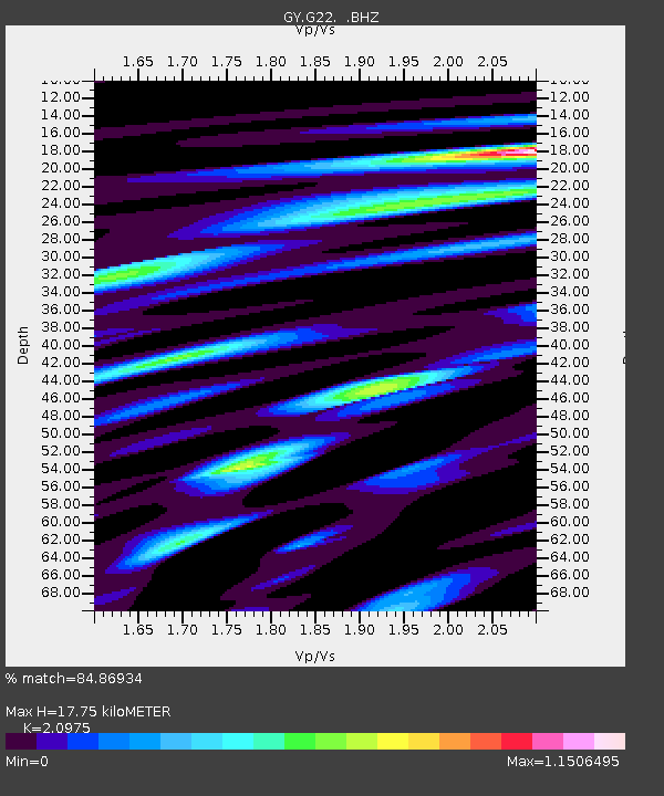
G22 GY.G22 - Earthquake Result Viewer
| Earthquake location: |
Central Mid-Atlantic Ridge |
| Earthquake latitude/longitude: |
0.7/-29.3 |
| Earthquake time(UTC): |
1993/09/20 (263) 10:17:41 GMT |
| Earthquake Depth: |
10 km |
| Earthquake Magnitude: |
5.7 MB, 5.9 MS, 6.3 UNKNOWN |
| Earthquake Catalog/Contributor: |
WHDF/NEIC |
|
| Network: |
GY Geyokcha, Turkmenistan Seismic Array |
| Station: |
G22 GY.G22 |
| Lat/Lon: |
37.93 N/58.11 E |
| Elevation: |
663 m |
|
| Distance: |
87.6 deg |
| Az: |
52.251 deg |
| Baz: |
268.996 deg |
| Ray Param: |
0.043244522 |
| Estimated Moho Depth: |
17.75 km |
| Estimated Crust Vp/Vs: |
2.10 |
| Assumed Crust Vp: |
6.53 km/s |
| Estimated Crust Vs: |
3.113 km/s |
| Estimated Crust Poisson's Ratio: |
0.35 |
|
| Radial Match: |
84.86934 % |
| Radial Bump: |
400 |
| Transverse Match: |
76.16304 % |
| Transverse Bump: |
400 |
| SOD ConfigId: |
4480 |
| Insert Time: |
2010-03-09 13:56:58.043 +0000 |
| GWidth: |
2.5 |
| Max Bumps: |
400 |
| Tol: |
0.001 |
|

Signal To Noise
| Channel | StoN | STA | LTA |
| GY:G22: :BHZ:19930920T10:29:58.100Z | 0.95601314 | 29.164196 | 30.506062 |
| GY:G22: :BHN:19930920T10:29:58.100Z | 1.6098689 | 65.05566 | 40.410534 |
| GY:G22: :BHE:19930920T10:29:58.100Z | 0.89555883 | 34.872997 | 38.939926 |
| Arrivals |
| Ps | 3.0 SECOND |
| PpPs | 8.3 SECOND |
| PsPs/PpSs | 11 SECOND |


