
Station GY G22 - GY.G22
Network: GY - Geyokcha, Turkmenistan Seismic Array
Nearby stations (2 deg radius)
| Station | Name | (Lat, Lon) | Start / End | Elevation |
| G22 | GY.G22 | (37.93, 58.11) | 1993-08-09 / 1994-08-19 | 663 m |
| Crust2 Type: | DE,thick Platform 1 km seds. |
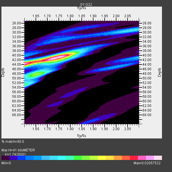
| Thickness Estimate: | 41 km |
| Thickness StdDev: | 2.7 km |
| Vp/Vs Estimate: | 1.74 |
| Vp/Vs StdDev: | 0.06 |
| Vs Estimate: | 3.748 km/s |
| Poisson's Ratio: | 0.25 |
| Peak Value: | 0.02 |
| Assumed Vp: | 6.53 km/s |
| Ps Weight: | 0.33333334 |
| PpPs Weight: | 0.33333334 |
| PsPs Weight: | 0.33333328 |
| Residual Complexity: | 0.539 |
| Nearby stations H: | 41 km +- 4.9 km |
| (2.0 deg) Vp/Vs: | 1.70 +- 0.12 |
12 with match > 90% ( 46.153847 %) and 19 with match > 80% ( 73.07692 %) out of 26.
Download stack as xyz text file.
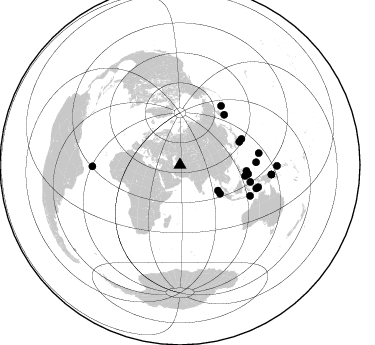
Azimuth Distribution of Events:
Prior Results for this Station
| Study | Thickness | Vp/Vs | Vp | Vs | Poissons Ratio | Extra |
| EARS | 41 km | 1.74 | 6.53 km/s | 3.748 km/s | 0.25 | |
| Crust2.0 | 46 km | 1.77 | 6.53 km/s | 3.68 km/s | 0.27 | DE,thick Platform 1 km seds. |
| Global Maxima | 41 km | 1.74 | 6.53 km/s | 3.748 km/s | 0.25 | amp=0.02057522 |
| Local Maxima 1 | 44 km | 1.60 | 6.53 km/s | 4.082 km/s | 0.18 | amp=0.014689984 |
| Local Maxima 2 | 52 km | 1.61 | 6.53 km/s | 4.069 km/s | 0.18 | amp=0.008848868 |
| Local Maxima 3 | 39 km | 1.78 | 6.53 km/s | 3.674 km/s | 0.27 | amp=0.0065162317 |
| Local Maxima 4 | 48 km | 1.67 | 6.53 km/s | 3.91 km/s | 0.22 | amp=0.0063190856 |
| Predicted Arrivals for vertical incidence (zero ray parameter) | |
| Ps | 4.66 SECOND |
| PpPs | 17.22 SECOND |
| PsPs/PpSs | 21.88 SECOND |
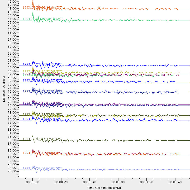
Events Processed for this Station
Download zip of receiver functions as SAC
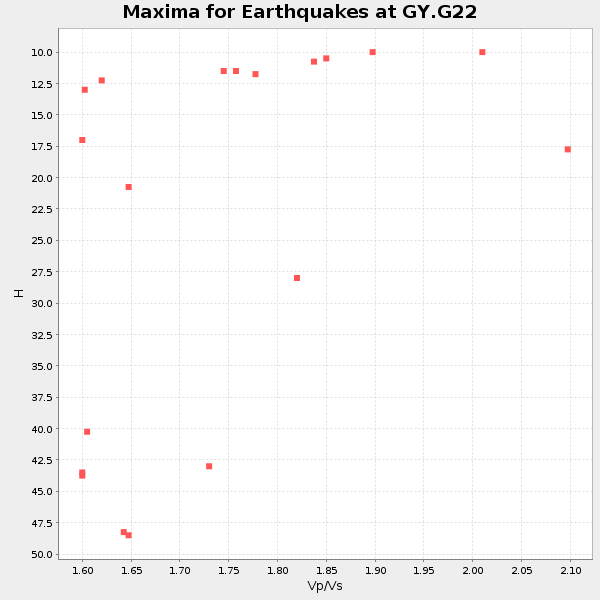
Plot maxima for each earthquake.
Events Used in the Stack
(19 events)| Radial Match | Distance | Baz | FERegion | Time | Lat/Lon | Depth | Magnitude |
| 96.9218 | 67.0 deg | 41.4 deg | Near East Coast Of Kamchatka | 1993/11/13 01:18:04 GMT | (51.9, 158.7) | 34 km | 6.5 MB, 7.1 MS, 6.9 UNKNOWN |
| 95.71201 | 76.1 deg | 88.11 deg | W. Caroline Islands, Micronesia | 1993/09/26 03:31:18 GMT | (10.0, 138.2) | 33 km | 6.1 MB, 6.0 MS, 5.9 UNKNOWN, 6.4 MW |
| 95.60795 | 72.4 deg | 103.596 deg | Northern Molucca Sea | 1993/12/09 04:32:22 GMT | (0.5, 126.0) | 33 km | 6.3 MB, 6.7 MS, 6.7 UNKNOWN, 6.8 MW |
| 95.46429 | 49.2 deg | 125.631 deg | Northern Sumatra, Indonesia | 1993/09/01 14:03:18 GMT | (2.9, 96.2) | 33 km | 5.8 MB, 6.2 MS, 6.0 UNKNOWN, 6.2 MW |
| 94.54138 | 92.0 deg | 95.931 deg | Eastern New Guinea Reg., P.N.G. | 1993/10/13 02:06:00 GMT | (-5.9, 146.0) | 24 km | 6.4 MB, 7.1 MS, 6.7 UNKNOWN, 7.1 ML |
| 94.47704 | 96.9 deg | 90.594 deg | New Ireland Region, P.N.G. | 1993/09/06 03:56:02 GMT | (-4.7, 153.2) | 73 km | 6.0 MB, 6.6 MS, 6.7 UNKNOWN, 6.6 MW |
| 93.41866 | 66.7 deg | 67.229 deg | Southeast Of Honshu, Japan | 1993/09/01 00:41:19 GMT | (31.7, 141.7) | 15 km | 5.5 MB, 5.7 MS |
| 92.50009 | 76.5 deg | 113.791 deg | Savu Sea | 1993/09/04 21:39:33 GMT | (-9.7, 122.6) | 39 km | 5.8 MB, 5.8 MS |
| 91.955284 | 66.0 deg | 99.618 deg | Mindanao, Philippines | 1993/10/16 10:52:26 GMT | (7.4, 123.4) | 33 km | 5.4 MB, 5.5 MS |
| 91.51582 | 79.8 deg | 107.061 deg | Banda Sea | 1993/08/29 09:57:49 GMT | (-7.0, 129.5) | 99 km | 5.7 MB |
| 90.702286 | 91.9 deg | 95.919 deg | Eastern New Guinea Reg., P.N.G. | 1993/10/25 10:27:01 GMT | (-5.9, 146.0) | 10 km | 6.4 MB, 7.1 MS, 7.1 UNKNOWN, 6.7 MW |
| 90.03694 | 45.6 deg | 123.951 deg | Nicobar Islands, India Region | 1993/08/28 20:14:44 GMT | (6.5, 94.7) | 120 km | 5.8 MB, 5.9 UNKNOWN, 5.9 MW |
| 88.98488 | 63.7 deg | 68.791 deg | Southeast Of Honshu, Japan | 1993/10/11 15:54:22 GMT | (32.0, 137.9) | 365 km | 6.5 MB, 6.8 UNKNOWN, 6.9 MW |
| 87.73356 | 79.6 deg | 81.554 deg | Mariana Islands | 1993/09/26 11:55:53 GMT | (13.0, 145.0) | 73 km | 5.8 MB, 5.6 UNKNOWN |
| 85.41016 | 66.7 deg | 95.124 deg | Philippine Islands Region | 1993/11/29 20:28:43 GMT | (10.2, 126.5) | 33 km | 5.6 MB, 5.7 MS |
| 85.18223 | 68.8 deg | 97.524 deg | Mindanao, Philippines | 1993/08/19 15:21:37 GMT | (7.2, 126.8) | 23 km | 5.4 MB, 5.7 MS, 5.6 UNKNOWN |
| 84.86934 | 87.6 deg | 268.996 deg | Central Mid-Atlantic Ridge | 1993/09/20 10:17:41 GMT | (0.7, -29.3) | 10 km | 5.7 MB, 5.9 MS, 6.3 UNKNOWN |
| 83.93859 | 81.1 deg | 105.817 deg | Tanimbar Islands Reg., Indonesia | 1993/12/20 13:56:18 GMT | (-6.9, 131.3) | 33 km | 6.1 MB, 5.7 MS, 5.6 UNKNOWN |
| 80.74894 | 72.2 deg | 34.925 deg | Near Islands, Aleutian Islands | 1993/12/16 20:11:25 GMT | (53.8, 171.5) | 30 km | 5.8 MB, 5.7 MS, 6.1 UNKNOWN |
Losers
(7 events)| Radial Match | Distance | Baz | FERegion | Time | Lat/Lon | Depth | Magnitude | Reason |
| 89.16641 | 79.5 deg | 32.589 deg | Andreanof Islands, Aleutian Is. | 1993/11/11 00:28:34 GMT | (50.2, -177.4) | 23 km | 6.3 MB, 5.7 MS, 6.0 UNKNOWN, 5.9 ML | |
| 79.86448 | 64.5 deg | 93.976 deg | Samar, Philippines | 1993/12/28 03:29:47 GMT | (12.4, 125.3) | 79 km | 5.5 MB | |
| 75.95 | 62.9 deg | 60.863 deg | Near East Coast Of Honshu, Japan | 1993/11/27 06:11:23 GMT | (38.6, 141.2) | 108 km | 6.0 MB, 5.9 UNKNOWN | |
| 75.14864 | 64.9 deg | 119.837 deg | Java Sea | 1993/11/28 10:50:26 GMT | (-5.6, 110.2) | 565 km | 5.6 MB | |
| 65.77444 | 91.9 deg | 95.964 deg | Eastern New Guinea Reg., P.N.G. | 1993/10/25 10:07:10 GMT | (-5.9, 145.9) | 10 km | 5.7 MB, 6.0 MS | |
| 51.148296 | 70.2 deg | 104.045 deg | Minahassa Peninsula, Sulawesi | 1993/11/17 02:42:30 GMT | (1.6, 124.0) | 246 km | 5.5 MB | |
| 48.802387 | 67.1 deg | 41.506 deg | Near East Coast Of Kamchatka | 1993/11/17 11:18:52 GMT | (51.8, 158.7) | 44 km | 6.0 MB, 5.6 MS |
