You are here: Home > Network List > GY - Geyokcha, Turkmenistan Seismic Array Stations List
> Station G22 GY.G22 > Earthquake Result Viewer
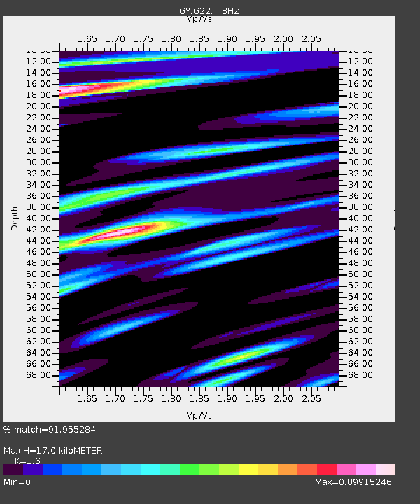
G22 GY.G22 - Earthquake Result Viewer
| Earthquake location: |
Mindanao, Philippines |
| Earthquake latitude/longitude: |
7.4/123.4 |
| Earthquake time(UTC): |
1993/10/16 (289) 10:52:26 GMT |
| Earthquake Depth: |
33 km |
| Earthquake Magnitude: |
5.4 MB, 5.5 MS |
| Earthquake Catalog/Contributor: |
WHDF/NEIC |
|
| Network: |
GY Geyokcha, Turkmenistan Seismic Array |
| Station: |
G22 GY.G22 |
| Lat/Lon: |
37.93 N/58.11 E |
| Elevation: |
663 m |
|
| Distance: |
66.0 deg |
| Az: |
308.171 deg |
| Baz: |
99.618 deg |
| Ray Param: |
0.057867303 |
| Estimated Moho Depth: |
17.0 km |
| Estimated Crust Vp/Vs: |
1.60 |
| Assumed Crust Vp: |
6.53 km/s |
| Estimated Crust Vs: |
4.082 km/s |
| Estimated Crust Poisson's Ratio: |
0.18 |
|
| Radial Match: |
91.955284 % |
| Radial Bump: |
400 |
| Transverse Match: |
74.77482 % |
| Transverse Bump: |
400 |
| SOD ConfigId: |
4480 |
| Insert Time: |
2010-03-09 13:57:02.966 +0000 |
| GWidth: |
2.5 |
| Max Bumps: |
400 |
| Tol: |
0.001 |
|

Signal To Noise
| Channel | StoN | STA | LTA |
| GY:G22: :BHZ:19931016T11:02:38.400012Z | 2.7032108 | 176.14908 | 65.1629 |
| GY:G22: :BHN:19931016T11:02:38.400012Z | 0.8763555 | 40.44197 | 46.147903 |
| GY:G22: :BHE:19931016T11:02:38.400012Z | 2.1719742 | 77.12796 | 35.510536 |
| Arrivals |
| Ps | 1.6 SECOND |
| PpPs | 6.5 SECOND |
| PsPs/PpSs | 8.1 SECOND |


