You are here: Home > Network List > GY - Geyokcha, Turkmenistan Seismic Array Stations List
> Station NH GY.NH > Earthquake Result Viewer
NH GY.NH - Earthquake Result Viewer
| Earthquake location: |
Java Sea |
| Earthquake latitude/longitude: |
-5.8/110.3 |
| Earthquake time(UTC): |
1994/09/28 (271) 16:39:52 GMT |
| Earthquake Depth: |
643 km |
| Earthquake Magnitude: |
5.7 MB, 6.7 UNKNOWN, 6.6 MW |
| Earthquake Catalog/Contributor: |
WHDF/NEIC |
|
| Network: |
GY Geyokcha, Turkmenistan Seismic Array |
| Station: |
NH GY.NH |
| Lat/Lon: |
37.93 N/58.11 E |
| Elevation: |
663 m |
|
| Distance: |
65.1 deg |
| Az: |
316.452 deg |
| Baz: |
119.899 deg |
| Ray Param: |
0.056030776 |
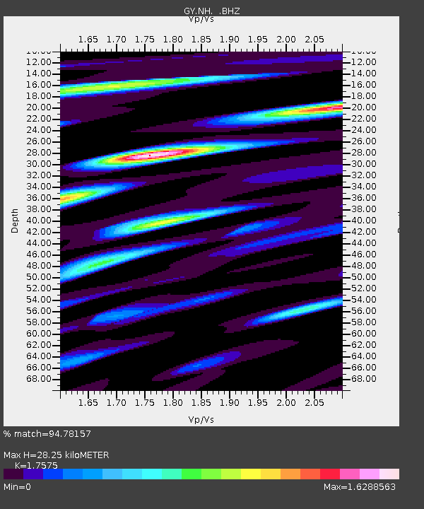
| Estimated Moho Depth: |
28.25 km |
| Estimated Crust Vp/Vs: |
1.76 |
| Assumed Crust Vp: |
6.53 km/s |
| Estimated Crust Vs: |
3.716 km/s |
| Estimated Crust Poisson's Ratio: |
0.26 |
|
| Radial Match: |
94.78157 % |
| Radial Bump: |
400 |
| Transverse Match: |
95.59282 % |
| Transverse Bump: |
400 |
| SOD ConfigId: |
4480 |
| Insert Time: |
2010-03-09 13:58:16.422 +0000 |
| GWidth: |
2.5 |
| Max Bumps: |
400 |
| Tol: |
0.001 |
|

Signal To Noise
| Channel | StoN | STA | LTA |
| GY:NH: :BHZ:19940928T16:49:00.798999Z | 101.7411 | 5884.8345 | 57.841274 |
| GY:NH: :BHN:19940928T16:49:00.798999Z | 54.608013 | 1973.8529 | 36.145847 |
| GY:NH: :BHE:19940928T16:49:00.798999Z | 58.84544 | 1937.3722 | 32.923065 |
| Arrivals |
| Ps | 3.4 SECOND |
| PpPs | 11 SECOND |
| PsPs/PpSs | 15 SECOND |


