
Station GY NH - GY.NH
Network: GY - Geyokcha, Turkmenistan Seismic Array
Nearby stations (2 deg radius)
| Station | Name | (Lat, Lon) | Start / End | Elevation |
| NH | GY.NH | (37.93, 58.11) | 1993-08-09 / 2599-12-31 | 663 m |
| Crust2 Type: | DE,thick Platform 1 km seds. |
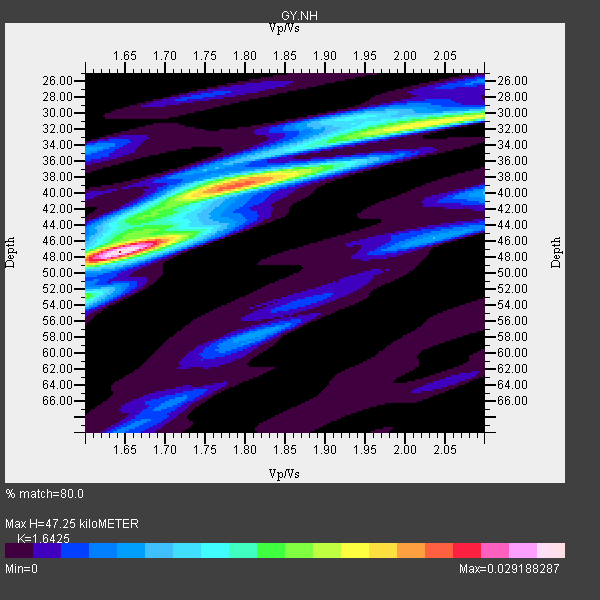
| Thickness Estimate: | 47 km |
| Thickness StdDev: | 4.7 km |
| Vp/Vs Estimate: | 1.64 |
| Vp/Vs StdDev: | 0.10 |
| Vs Estimate: | 3.976 km/s |
| Poisson's Ratio: | 0.21 |
| Peak Value: | 0.03 |
| Assumed Vp: | 6.53 km/s |
| Ps Weight: | 0.33333334 |
| PpPs Weight: | 0.33333334 |
| PsPs Weight: | 0.33333328 |
| Residual Complexity: | 0.759 |
| Nearby stations H: | 41 km +- 4.9 km |
| (2.0 deg) Vp/Vs: | 1.70 +- 0.12 |
9 with match > 90% ( 60.0 %) and 13 with match > 80% ( 86.666664 %) out of 15.
Download stack as xyz text file.
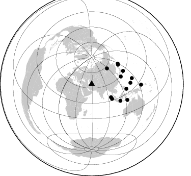
Azimuth Distribution of Events:
Prior Results for this Station
| Study | Thickness | Vp/Vs | Vp | Vs | Poissons Ratio | Extra |
| EARS | 47 km | 1.64 | 6.53 km/s | 3.976 km/s | 0.21 | |
| Crust2.0 | 46 km | 1.77 | 6.53 km/s | 3.68 km/s | 0.27 | DE,thick Platform 1 km seds. |
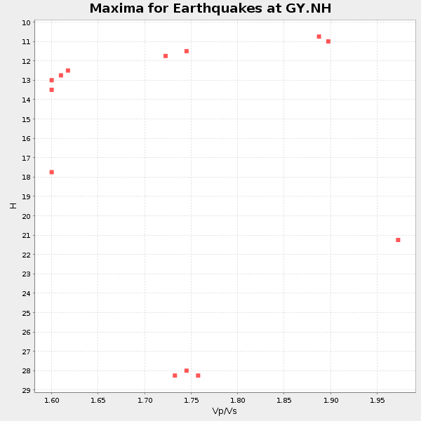
| Global Maxima | 47 km | 1.64 | 6.53 km/s | 3.976 km/s | 0.21 | amp=0.029188287 |
| Local Maxima 1 | 39 km | 1.79 | 6.53 km/s | 3.653 km/s | 0.27 | amp=0.021722216 |
| Local Maxima 2 | 31 km | 2.06 | 6.53 km/s | 3.17 km/s | 0.35 | amp=0.017403575 |
| Local Maxima 3 | 43 km | 1.66 | 6.53 km/s | 3.922 km/s | 0.22 | amp=0.00967805 |
| Local Maxima 4 | 30 km | 1.93 | 6.53 km/s | 3.388 km/s | 0.32 | amp=0.008613531 |
| Predicted Arrivals for vertical incidence (zero ray parameter) | |
| Ps | 4.65 SECOND |
| PpPs | 19.12 SECOND |
| PsPs/PpSs | 23.77 SECOND |
Events Processed for this Station
Download zip of receiver functions as SAC
Plot maxima for each earthquake.
Events Used in the Stack
(13 events)| Radial Match | Distance | Baz | FERegion | Time | Lat/Lon | Depth | Magnitude |
| 95.78048 | 76.1 deg | 88.11 deg | W. Caroline Islands, Micronesia | 1993/09/26 03:31:18 GMT | (10.0, 138.2) | 33 km | 6.1 MB, 6.0 MS, 5.9 UNKNOWN, 6.4 MW |
| 95.05011 | 49.2 deg | 125.631 deg | Northern Sumatra, Indonesia | 1993/09/01 14:03:18 GMT | (2.9, 96.2) | 33 km | 5.8 MB, 6.2 MS, 6.0 UNKNOWN, 6.2 MW |
| 94.78157 | 65.1 deg | 119.899 deg | Java Sea | 1994/09/28 16:39:52 GMT | (-5.8, 110.3) | 643 km | 5.7 MB, 6.7 UNKNOWN, 6.6 MW |
| 94.5297 | 96.9 deg | 90.594 deg | New Ireland Region, P.N.G. | 1993/09/06 03:56:02 GMT | (-4.7, 153.2) | 73 km | 6.0 MB, 6.6 MS, 6.7 UNKNOWN, 6.6 MW |
| 94.06703 | 65.2 deg | 51.772 deg | Kuril Islands | 1994/08/20 04:38:51 GMT | (44.7, 149.1) | 33 km | 6.1 MB, 6.0 MS, 5.7 UNKNOWN, 6.3 MW |
| 93.3823 | 76.5 deg | 113.791 deg | Savu Sea | 1993/09/04 21:39:33 GMT | (-9.7, 122.6) | 39 km | 5.8 MB, 5.8 MS |
| 93.303474 | 59.1 deg | 75.343 deg | Ryukyu Islands, Japan | 1994/09/13 04:28:01 GMT | (29.3, 129.9) | 37 km | 5.8 MB, 6.3 MS, 6.2 UNKNOWN, 6.1 MW |
| 92.531784 | 66.7 deg | 67.229 deg | Southeast Of Honshu, Japan | 1993/09/01 00:41:19 GMT | (31.7, 141.7) | 15 km | 5.5 MB, 5.7 MS |
| 90.2362 | 45.6 deg | 123.951 deg | Nicobar Islands, India Region | 1993/08/28 20:14:44 GMT | (6.5, 94.7) | 120 km | 5.8 MB, 5.9 UNKNOWN, 5.9 MW |
| 88.378876 | 64.5 deg | 53.635 deg | Kuril Islands | 1994/10/18 17:12:51 GMT | (43.6, 147.1) | 66 km | 6.1 MB, 6.1 UNKNOWN, 5.9 MW |
| 88.19354 | 68.8 deg | 97.524 deg | Mindanao, Philippines | 1993/08/19 15:21:37 GMT | (7.2, 126.8) | 23 km | 5.4 MB, 5.7 MS, 5.6 UNKNOWN |
| 88.04521 | 43.1 deg | 44.293 deg | East Of Lake Baykal, Russia | 1994/08/21 15:56:01 GMT | (56.7, 117.8) | 33 km | 5.7 MB, 5.8 MS, 6.0 UNKNOWN, 6.0 MW |
| 84.28984 | 79.6 deg | 81.554 deg | Mariana Islands | 1993/09/26 11:55:53 GMT | (13.0, 145.0) | 73 km | 5.8 MB, 5.6 UNKNOWN |
Losers
(2 events)| Radial Match | Distance | Baz | FERegion | Time | Lat/Lon | Depth | Magnitude | Reason |
| 87.56683 | 79.8 deg | 107.061 deg | Banda Sea | 1993/08/29 09:57:49 GMT | (-7.0, 129.5) | 99 km | 5.7 MB | |
| 77.7767 | 64.5 deg | 93.976 deg | Samar, Philippines | 1993/12/28 03:29:47 GMT | (12.4, 125.3) | 79 km | 5.5 MB |
