You are here: Home > Network List > GY - Geyokcha, Turkmenistan Seismic Array Stations List
> Station NH GY.NH > Earthquake Result Viewer
NH GY.NH - Earthquake Result Viewer
| Earthquake location: |
Southeast Of Honshu, Japan |
| Earthquake latitude/longitude: |
31.7/141.7 |
| Earthquake time(UTC): |
1993/09/01 (244) 00:41:19 GMT |
| Earthquake Depth: |
15 km |
| Earthquake Magnitude: |
5.5 MB, 5.7 MS |
| Earthquake Catalog/Contributor: |
WHDF/NEIC |
|
| Network: |
GY Geyokcha, Turkmenistan Seismic Array |
| Station: |
NH GY.NH |
| Lat/Lon: |
37.93 N/58.11 E |
| Elevation: |
663 m |
|
| Distance: |
66.7 deg |
| Az: |
301.181 deg |
| Baz: |
67.229 deg |
| Ray Param: |
0.057422962 |
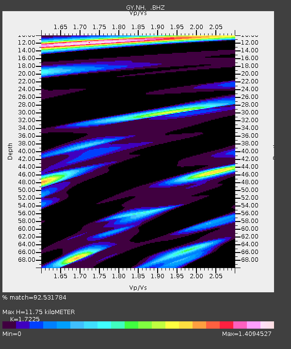
| Estimated Moho Depth: |
11.75 km |
| Estimated Crust Vp/Vs: |
1.72 |
| Assumed Crust Vp: |
6.53 km/s |
| Estimated Crust Vs: |
3.791 km/s |
| Estimated Crust Poisson's Ratio: |
0.25 |
|
| Radial Match: |
92.531784 % |
| Radial Bump: |
400 |
| Transverse Match: |
83.2779 % |
| Transverse Bump: |
400 |
| SOD ConfigId: |
4480 |
| Insert Time: |
2010-03-09 13:58:21.149 +0000 |
| GWidth: |
2.5 |
| Max Bumps: |
400 |
| Tol: |
0.001 |
|

Signal To Noise
| Channel | StoN | STA | LTA |
| GY:NH: :BHZ:19930901T00:51:38.398999Z | 13.339719 | 467.82227 | 35.069874 |
| GY:NH: :BHN:19930901T00:51:38.398999Z | 1.7544022 | 59.952488 | 34.172604 |
| GY:NH: :BHE:19930901T00:51:38.398999Z | 2.6782978 | 78.40197 | 29.273058 |
| Arrivals |
| Ps | 1.4 SECOND |
| PpPs | 4.7 SECOND |
| PsPs/PpSs | 6.0 SECOND |


