You are here: Home > Network List > GY - Geyokcha, Turkmenistan Seismic Array Stations List
> Station NH GY.NH > Earthquake Result Viewer
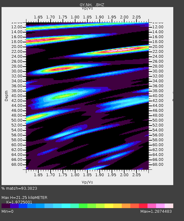
NH GY.NH - Earthquake Result Viewer
| Earthquake location: |
Savu Sea |
| Earthquake latitude/longitude: |
-9.7/122.6 |
| Earthquake time(UTC): |
1993/09/04 (247) 21:39:33 GMT |
| Earthquake Depth: |
39 km |
| Earthquake Magnitude: |
5.8 MB, 5.8 MS |
| Earthquake Catalog/Contributor: |
WHDF/NEIC |
|
| Network: |
GY Geyokcha, Turkmenistan Seismic Array |
| Station: |
NH GY.NH |
| Lat/Lon: |
37.93 N/58.11 E |
| Elevation: |
663 m |
|
| Distance: |
76.5 deg |
| Az: |
312.788 deg |
| Baz: |
113.791 deg |
| Ray Param: |
0.050910216 |
| Estimated Moho Depth: |
21.25 km |
| Estimated Crust Vp/Vs: |
1.97 |
| Assumed Crust Vp: |
6.53 km/s |
| Estimated Crust Vs: |
3.311 km/s |
| Estimated Crust Poisson's Ratio: |
0.33 |
|
| Radial Match: |
93.3823 % |
| Radial Bump: |
400 |
| Transverse Match: |
91.93849 % |
| Transverse Bump: |
400 |
| SOD ConfigId: |
4480 |
| Insert Time: |
2010-03-09 13:58:23.290 +0000 |
| GWidth: |
2.5 |
| Max Bumps: |
400 |
| Tol: |
0.001 |
|

Signal To Noise
| Channel | StoN | STA | LTA |
| GY:NH: :BHZ:19930904T21:50:48.599011Z | 8.520049 | 442.79626 | 51.971092 |
| GY:NH: :BHN:19930904T21:50:48.599011Z | 2.7481408 | 72.63426 | 26.430328 |
| GY:NH: :BHE:19930904T21:50:48.599011Z | 5.716283 | 185.41212 | 32.435787 |
| Arrivals |
| Ps | 3.3 SECOND |
| PpPs | 9.4 SECOND |
| PsPs/PpSs | 13 SECOND |


