You are here: Home > Network List > AK - Alaska Regional Network Stations List
> Station D22K Ayikyak River, AK, USA > Earthquake Result Viewer
D22K Ayikyak River, AK, USA - Earthquake Result Viewer
| Earthquake location: |
Southern Iran |
| Earthquake latitude/longitude: |
27.7/56.1 |
| Earthquake time(UTC): |
2021/11/14 (318) 12:07:03 GMT |
| Earthquake Depth: |
7.0 km |
| Earthquake Magnitude: |
6.0 Mwb |
| Earthquake Catalog/Contributor: |
NEIC PDE/us |
|
| Network: |
AK Alaska Regional Network |
| Station: |
D22K Ayikyak River, AK, USA |
| Lat/Lon: |
68.88 N/152.68 W |
| Elevation: |
532 m |
|
| Distance: |
81.4 deg |
| Az: |
10.154 deg |
| Baz: |
334.455 deg |
| Ray Param: |
0.04762699 |
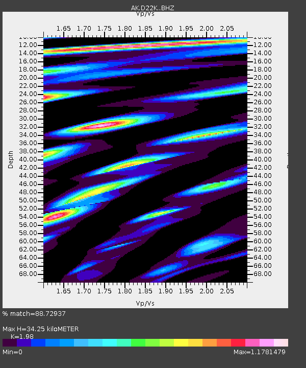
| Estimated Moho Depth: |
34.25 km |
| Estimated Crust Vp/Vs: |
1.98 |
| Assumed Crust Vp: |
6.221 km/s |
| Estimated Crust Vs: |
3.142 km/s |
| Estimated Crust Poisson's Ratio: |
0.33 |
|
| Radial Match: |
88.72937 % |
| Radial Bump: |
400 |
| Transverse Match: |
65.78673 % |
| Transverse Bump: |
400 |
| SOD ConfigId: |
26694651 |
| Insert Time: |
2021-11-28 12:08:59.379 +0000 |
| GWidth: |
2.5 |
| Max Bumps: |
400 |
| Tol: |
0.001 |
|

Signal To Noise
| Channel | StoN | STA | LTA |
| AK:D22K: :BHZ:20211114T12:18:49.440027Z | 10.467508 | 1.2427301E-6 | 1.18722625E-7 |
| AK:D22K: :BHN:20211114T12:18:49.440027Z | 1.6100581 | 3.070659E-7 | 1.9071729E-7 |
| AK:D22K: :BHE:20211114T12:18:49.440027Z | 1.6792922 | 1.8104576E-7 | 1.0781075E-7 |
| Arrivals |
| Ps | 5.5 SECOND |
| PpPs | 16 SECOND |
| PsPs/PpSs | 22 SECOND |


