You are here: Home > Network List > XE99 - Broadband Experiment Across Alaskan Range Stations List
> Station GNR Garner > Earthquake Result Viewer
GNR Garner - Earthquake Result Viewer
| Earthquake location: |
Southeast Of Loyalty Islands |
| Earthquake latitude/longitude: |
-22.0/170.1 |
| Earthquake time(UTC): |
2001/02/28 (059) 13:05:31 GMT |
| Earthquake Depth: |
10 km |
| Earthquake Magnitude: |
5.8 MB, 6.1 MS, 6.2 MW |
| Earthquake Catalog/Contributor: |
WHDF/NEIC |
|
| Network: |
XE Broadband Experiment Across Alaskan Range |
| Station: |
GNR Garner |
| Lat/Lon: |
63.83 N/148.98 W |
| Elevation: |
581 m |
|
| Distance: |
91.3 deg |
| Az: |
16.884 deg |
| Baz: |
217.442 deg |
| Ray Param: |
0.041610863 |
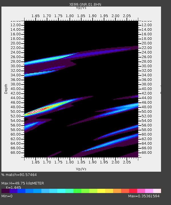
| Estimated Moho Depth: |
49.75 km |
| Estimated Crust Vp/Vs: |
1.64 |
| Assumed Crust Vp: |
6.566 km/s |
| Estimated Crust Vs: |
3.992 km/s |
| Estimated Crust Poisson's Ratio: |
0.21 |
|
| Radial Match: |
90.57464 % |
| Radial Bump: |
365 |
| Transverse Match: |
75.49103 % |
| Transverse Bump: |
400 |
| SOD ConfigId: |
3744 |
| Insert Time: |
2010-03-09 14:17:12.370 +0000 |
| GWidth: |
2.5 |
| Max Bumps: |
400 |
| Tol: |
0.001 |
|

Signal To Noise
| Channel | StoN | STA | LTA |
| XE:GNR:01:BHN:20010228T13:18:05.752Z | 0.7977231 | 9.377628E-7 | 1.1755493E-6 |
| XE:GNR:01:BHE:20010228T13:18:05.752Z | 1.4343615 | 5.2074265E-6 | 3.6304841E-6 |
| XE:GNR:01:BHZ:20010228T13:18:05.752Z | 1.4639921 | 4.994153E-6 | 3.4113252E-6 |
| Arrivals |
| Ps | 5.0 SECOND |
| PpPs | 20 SECOND |
| PsPs/PpSs | 25 SECOND |


