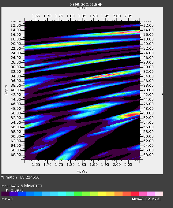
GOO Igloo - Earthquake Result Viewer

Earthquake location: Near Coast Of Peru
Earthquake latitude/longitude: -16.3/-73.6
Earthquake time(UTC): 2001/06/23 (174) 20:33:14 GMT
Earthquake Depth: 33 km
Earthquake Magnitude: 6.7 MB, 8.2 MS, 8.4 MW, 7.8 ME
Earthquake Catalog/Contributor: WHDF/NEIC
Network: XE Broadband Experiment Across Alaskan Range
Station: GOO Igloo
Lat/Lon: 63.23 N/149.27 W
Elevation: 700 m
Distance: 98.1 deg
Az: 333.701 deg
Baz: 109.997 deg
Ray Param: 0.040004343
Estimated Moho Depth: 14.5 km
Estimated Crust Vp/Vs: 2.10
Assumed Crust Vp: 6.566 km/s
Estimated Crust Vs: 3.13 km/s
Estimated Crust Poisson's Ratio: 0.35
Radial Match: 83.224556 %
Radial Bump: 400
Transverse Match: 81.19208 %
Transverse Bump: 400
SOD ConfigId: 4714
Insert Time: 2010-03-09 14:18:28.198 +0000
GWidth: 2.5
Max Bumps: 400
Tol: 0.001

Signal To Noise

ChannelStoNSTALTA
XE:GOO:01:BHN:20010623T20:46:15.700007Z2.26785542.4245404E-71.0690894E-7
XE:GOO:01:BHE:20010623T20:46:15.700007Z4.307573.372802E-77.8299415E-8
XE:GOO:01:BHZ:20010623T20:46:15.700007Z9.0535531.2849904E-61.4193218E-7
Arrivals
Ps2.5 SECOND
PpPs6.7 SECOND
PsPs/PpSs9.2 SECOND