
Station XE GOO - Igloo
Network: XE99 - Broadband Experiment Across Alaskan Range
Nearby stations (2 deg radius)

| Station | Name | (Lat, Lon) | Start / End | Elevation |
| GOO | Igloo | (63.23, -149.27) | 2000-06-04 / 2001-12-31 | 700 m |
| Crust2 Type: | L8,thin continental arc, Cordilleras, 0.5 km seds. |
| Thickness Estimate: | 46 km |
| Thickness StdDev: | 6.5 km |
| Vp/Vs Estimate: | 1.62 |
| Vp/Vs StdDev: | 0.10 |
| Vs Estimate: | 4.053 km/s |
| Poisson's Ratio: | 0.19 |
| Peak Value: | 0.02 |
| Assumed Vp: | 6.566 km/s |
| Ps Weight: | 0.33333334 |
| PpPs Weight: | 0.33333334 |
| PsPs Weight: | 0.33333328 |
| Residual Complexity: | 0.840 |
| Nearby stations H: | +- |
| (2.0 deg) Vp/Vs: | +- |
1 with match > 90% ( 4.347826 %) and 23 with match > 80% ( 100.0 %) out of 23.
Download stack as xyz text file.
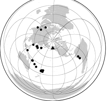
Azimuth Distribution of Events:
Prior Results for this Station
| Study | Thickness | Vp/Vs | Vp | Vs | Poissons Ratio | Extra |
| EARS | 46 km | 1.62 | 6.566 km/s | 4.053 km/s | 0.19 | |
| Crust2.0 | 34 km | 1.77 | 6.566 km/s | 3.707 km/s | 0.27 | L8,thin continental arc, Cordilleras, 0.5 km seds. |
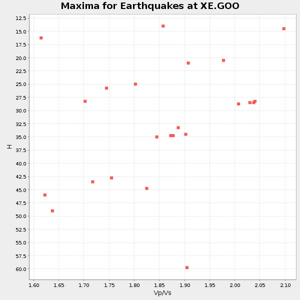
| Global Maxima | 46 km | 1.62 | 6.566 km/s | 4.053 km/s | 0.19 | amp=0.022530673 |
| Local Maxima 1 | 34 km | 1.83 | 6.566 km/s | 3.588 km/s | 0.29 | amp=0.01986357 |
| Local Maxima 2 | 26 km | 1.74 | 6.566 km/s | 3.779 km/s | 0.25 | amp=0.016050138 |
| Local Maxima 3 | 28 km | 2.03 | 6.566 km/s | 3.231 km/s | 0.34 | amp=0.0117593445 |
| Local Maxima 4 | 28 km | 1.73 | 6.566 km/s | 3.806 km/s | 0.25 | amp=0.011099764 |
| Predicted Arrivals for vertical incidence (zero ray parameter) | |
| Ps | 4.34 SECOND |
| PpPs | 18.35 SECOND |
| PsPs/PpSs | 22.70 SECOND |
Events Processed for this Station
Download zip of receiver functions as SAC
Plot maxima for each earthquake.
Events Used in the Stack
(23 events)| Radial Match | Distance | Baz | FERegion | Time | Lat/Lon | Depth | Magnitude |
| 90.39026 | 88.2 deg | 324.224 deg | Southern India | 2001/01/26 03:16:40 GMT | (23.4, 70.2) | 16 km | 6.9 MB, 8.0 MS, 7.7 MW, 7.7 ME |
| 87.347305 | 82.5 deg | 229.001 deg | Solomon Islands | 2001/05/09 17:38:26 GMT | (-10.3, 161.2) | 68 km | 6.0 MB, 5.9 MS, 6.3 MW, 6.2 MW |
| 87.14566 | 80.6 deg | 238.388 deg | New Ireland Region, P.N.G. | 2000/11/16 05:21:22 GMT | (-5.1, 153.2) | 33 km | 6.0 MB |
| 86.703545 | 75.8 deg | 341.019 deg | Turkmenistan | 2000/12/06 17:11:06 GMT | (39.6, 54.8) | 30 km | 6.7 MB, 7.5 MS, 7.0 MW, 6.9 ME |
| 86.41484 | 87.4 deg | 205.394 deg | Fiji Islands Region | 2001/07/04 07:06:31 GMT | (-21.7, -176.7) | 185 km | 5.9 MB, 5.8 MS, 6.5 MW, 6.5 MW |
| 86.2479 | 83.9 deg | 206.376 deg | Fiji Islands Region | 2001/04/28 04:49:53 GMT | (-18.1, -176.9) | 352 km | 6.2 MB, 6.8 MW, 6.8 MW |
| 85.70677 | 82.4 deg | 203.722 deg | Tonga Islands | 2000/09/26 06:17:52 GMT | (-17.2, -173.9) | 56 km | 6.1 MB, 6.1 MS, 6.4 MW, 6.1 ME |
| 85.59061 | 55.0 deg | 277.109 deg | Western Honshu, Japan | 2001/03/24 06:27:53 GMT | (34.1, 132.5) | 50 km | 6.4 MB, 6.5 MS, 6.8 MW, 6.4 ME |
| 85.34357 | 87.3 deg | 207.715 deg | Fiji Islands Region | 2000/12/18 01:19:21 GMT | (-21.2, -179.1) | 628 km | 6.4 MB, 6.6 MW, 6.5 MW |
| 84.61083 | 81.5 deg | 239.573 deg | New Britain Region, P.N.G. | 2000/11/17 21:01:56 GMT | (-5.5, 151.8) | 33 km | 6.2 MB, 8.0 MS, 7.6 MW, 6.9 ME |
| 83.9367 | 84.9 deg | 221.974 deg | Vanuatu Islands | 2001/01/09 16:49:28 GMT | (-14.9, 167.2) | 103 km | 6.3 MB, 6.6 MS, 7.6 ME, 7.0 MW |
| 83.298096 | 39.5 deg | 271.586 deg | Kuril Islands | 2001/05/25 00:40:50 GMT | (44.3, 148.4) | 33 km | 6.1 MB, 6.7 MS, 6.7 MW, 6.6 MW |
| 83.224556 | 98.1 deg | 109.997 deg | Near Coast Of Peru | 2001/06/23 20:33:14 GMT | (-16.3, -73.6) | 33 km | 6.7 MB, 8.2 MS, 8.4 MW, 7.8 ME |
| 83.01192 | 86.3 deg | 207.973 deg | Fiji Islands Region | 2000/09/02 17:02:19 GMT | (-20.1, -179.1) | 688 km | 5.5 MB, 6.0 MW, 6.0 MW |
| 82.48112 | 86.4 deg | 265.646 deg | Northern Molucca Sea | 2001/02/24 07:23:48 GMT | (1.3, 126.2) | 35 km | 6.6 MB, 7.0 MS, 7.1 MW, 7.1 ME |
| 82.10158 | 90.6 deg | 107.817 deg | Central Peru | 2001/08/06 17:08:46 GMT | (-8.5, -75.0) | 137 km | 5.4 MB, 5.5 MW, 5.5 MW |
| 81.92388 | 39.5 deg | 271.405 deg | Kuril Islands | 2001/06/24 13:18:51 GMT | (44.2, 148.5) | 33 km | 5.8 MB, 5.7 MS, 6.0 MW |
| 81.577126 | 51.9 deg | 271.478 deg | Near S. Coast Of Honshu, Japan | 2000/07/01 07:01:55 GMT | (34.2, 139.1) | 10 km | 6.0 MB, 6.1 MS, 6.2 MW, 6.2 MW |
| 80.95205 | 67.8 deg | 280.475 deg | Taiwan Region | 2001/06/14 02:35:25 GMT | (24.5, 122.0) | 32 km | 5.7 MB, 5.6 MS, 5.9 MW, 5.9 MW |
| 80.45403 | 87.2 deg | 203.597 deg | Tonga Islands | 2000/08/17 00:04:29 GMT | (-21.9, -174.8) | 33 km | 5.4 MB, 5.8 MS, 5.9 MW, 5.7 MW |
| 80.39065 | 97.8 deg | 110.218 deg | Near Coast Of Peru | 2001/07/05 13:53:48 GMT | (-16.1, -74.0) | 62 km | 6.2 MB, 6.6 MW, 6.5 ME |
| 80.31084 | 75.6 deg | 327.532 deg | Hindu Kush Region, Afghanistan | 2001/02/25 02:21:59 GMT | (36.4, 70.9) | 202 km | 5.8 MB, 6.3 MW, 6.1 MW |
| 80.10617 | 53.5 deg | 277.513 deg | Western Honshu, Japan | 2000/10/06 04:30:19 GMT | (35.5, 133.1) | 10 km | 5.8 MB, 6.8 MS, 7.0 ME, 6.7 MW |
Losers
(0 events)| Radial Match | Distance | Baz | FERegion | Time | Lat/Lon | Depth | Magnitude | Reason |
