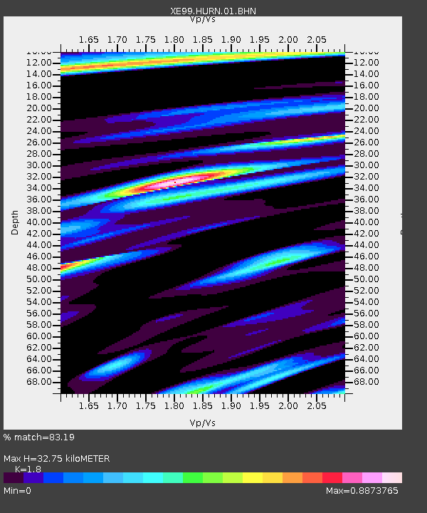
HURN HURRICANE NORTH - Earthquake Result Viewer

Earthquake location: Solomon Islands
Earthquake latitude/longitude: -7.3/156.0
Earthquake time(UTC): 2001/04/19 (109) 20:58:26 GMT
Earthquake Depth: 20 km
Earthquake Magnitude: 5.7 MB, 6.1 MS, 6.2 MW, 5.9 ME
Earthquake Catalog/Contributor: WHDF/NEIC
Network: XE Broadband Experiment Across Alaskan Range
Station: HURN HURRICANE NORTH
Lat/Lon: 63.00 N/149.61 W
Elevation: 607 m
Distance: 81.3 deg
Az: 22.059 deg
Baz: 234.709 deg
Ray Param: 0.047653936
Estimated Moho Depth: 32.75 km
Estimated Crust Vp/Vs: 1.80
Assumed Crust Vp: 6.566 km/s
Estimated Crust Vs: 3.648 km/s
Estimated Crust Poisson's Ratio: 0.28
Radial Match: 83.19 %
Radial Bump: 400
Transverse Match: 69.54531 %
Transverse Bump: 400
SOD ConfigId: 4714
Insert Time: 2010-03-09 14:19:10.896 +0000
GWidth: 2.5
Max Bumps: 400
Tol: 0.001

Signal To Noise

ChannelStoNSTALTA
XE:HURN:01:BHN:20010419T21:10:09.653Z2.21042351.6748291E-77.5769606E-8
XE:HURN:01:BHE:20010419T21:10:09.653Z3.7093752.7875177E-77.514791E-8
XE:HURN:01:BHZ:20010419T21:10:09.653Z5.2460644.856762E-79.257916E-8
Arrivals
Ps4.1 SECOND
PpPs14 SECOND
PsPs/PpSs18 SECOND