
Station XE HURN - HURRICANE NORTH
Network: XE99 - Broadband Experiment Across Alaskan Range
Nearby stations (2 deg radius)
| Station | Name | (Lat, Lon) | Start / End | Elevation |
| HURN | HURRICANE NORTH | (63.00, -149.61) | 1999-05-30 / 2001-12-31 | 607 m |
| Crust2 Type: | L8,thin continental arc, Cordilleras, 0.5 km seds. |
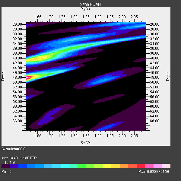
| Thickness Estimate: | 48 km |
| Thickness StdDev: | 3.4 km |
| Vp/Vs Estimate: | 1.60 |
| Vp/Vs StdDev: | 0.03 |
| Vs Estimate: | 4.104 km/s |
| Poisson's Ratio: | 0.18 |
| Peak Value: | 0.02 |
| Assumed Vp: | 6.566 km/s |
| Ps Weight: | 0.33333334 |
| PpPs Weight: | 0.33333334 |
| PsPs Weight: | 0.33333328 |
| Residual Complexity: | 0.816 |
| Nearby stations H: | +- |
| (2.0 deg) Vp/Vs: | +- |
10 with match > 90% ( 32.258064 %) and 31 with match > 80% ( 100.0 %) out of 31.
Download stack as xyz text file.
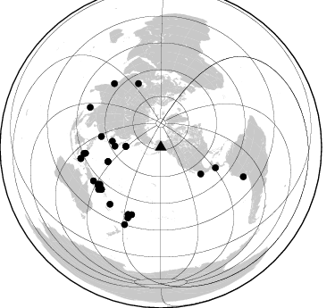
Azimuth Distribution of Events:
Prior Results for this Station
| Study | Thickness | Vp/Vs | Vp | Vs | Poissons Ratio | Extra |
| EARS | 48 km | 1.60 | 6.566 km/s | 4.104 km/s | 0.18 | |
| Crust2.0 | 34 km | 1.77 | 6.566 km/s | 3.707 km/s | 0.27 | L8,thin continental arc, Cordilleras, 0.5 km seds. |
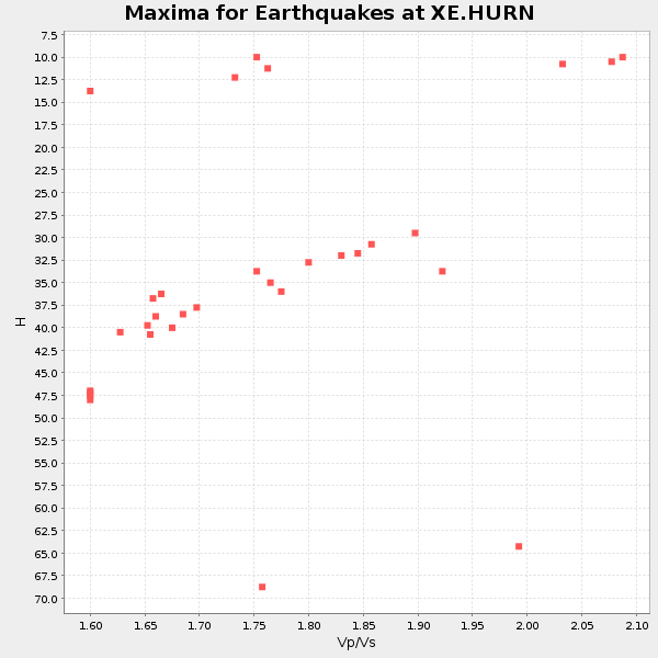
| Global Maxima | 48 km | 1.60 | 6.566 km/s | 4.104 km/s | 0.18 | amp=0.023972156 |
| Local Maxima 1 | 40 km | 1.64 | 6.566 km/s | 3.992 km/s | 0.21 | amp=0.016686792 |
| Local Maxima 2 | 35 km | 1.81 | 6.566 km/s | 3.628 km/s | 0.28 | amp=0.010855286 |
| Local Maxima 3 | 25 km | 2.04 | 6.566 km/s | 3.223 km/s | 0.34 | amp=0.0064807157 |
| Local Maxima 4 | 41 km | 1.67 | 6.566 km/s | 3.932 km/s | 0.22 | amp=0.0057150684 |
| Predicted Arrivals for vertical incidence (zero ray parameter) | |
| Ps | 4.39 SECOND |
| PpPs | 19.01 SECOND |
| PsPs/PpSs | 23.39 SECOND |
Events Processed for this Station
Download zip of receiver functions as SAC
Plot maxima for each earthquake.
Events Used in the Stack
(31 events)| Radial Match | Distance | Baz | FERegion | Time | Lat/Lon | Depth | Magnitude |
| 96.144 | 65.4 deg | 110.51 deg | El Salvador | 2001/01/13 17:33:32 GMT | (13.0, -88.7) | 60 km | 6.4 MB, 7.8 MS, 7.7 MW, 7.5 ME |
| 95.15854 | 98.1 deg | 109.736 deg | Near Coast Of Peru | 2001/06/23 20:33:14 GMT | (-16.3, -73.6) | 33 km | 6.7 MB, 8.2 MS, 8.4 MW, 7.8 ME |
| 94.82434 | 81.3 deg | 239.292 deg | New Britain Region, P.N.G. | 2000/11/17 21:01:56 GMT | (-5.5, 151.8) | 33 km | 6.2 MB, 8.0 MS, 7.6 MW, 6.9 ME |
| 93.69745 | 90.4 deg | 262.031 deg | Seram, Indonesia | 2000/08/28 15:38:06 GMT | (-4.0, 127.3) | 10 km | 5.8 MB, 5.8 MS, 6.1 MW |
| 92.727715 | 88.3 deg | 323.933 deg | Southern India | 2001/01/26 03:16:40 GMT | (23.4, 70.2) | 16 km | 6.9 MB, 8.0 MS, 7.7 MW, 7.7 ME |
| 92.592285 | 85.2 deg | 221.763 deg | Vanuatu Islands | 2000/10/04 16:58:44 GMT | (-15.4, 166.9) | 23 km | 6.1 MB, 6.9 MS, 6.8 MW, 6.5 ME |
| 91.850174 | 82.2 deg | 203.417 deg | Tonga Islands | 2000/09/26 06:17:52 GMT | (-17.2, -173.9) | 56 km | 6.1 MB, 6.1 MS, 6.4 MW, 6.1 ME |
| 91.767296 | 75.9 deg | 340.775 deg | Turkmenistan | 2000/12/06 17:11:06 GMT | (39.6, 54.8) | 30 km | 6.7 MB, 7.5 MS, 7.0 MW, 6.9 ME |
| 90.392365 | 86.2 deg | 265.361 deg | Northern Molucca Sea | 2001/02/24 07:23:48 GMT | (1.3, 126.2) | 35 km | 6.6 MB, 7.0 MS, 7.1 MW, 7.1 ME |
| 90.183044 | 83.6 deg | 206.073 deg | Fiji Islands Region | 2001/04/28 04:49:53 GMT | (-18.1, -176.9) | 352 km | 6.2 MB, 6.8 MW, 6.8 MW |
| 88.38319 | 54.8 deg | 276.984 deg | Western Honshu, Japan | 2001/03/24 06:27:53 GMT | (34.1, 132.5) | 50 km | 6.4 MB, 6.5 MS, 6.8 MW, 6.4 ME |
| 87.98494 | 79.7 deg | 238.669 deg | New Britain Region, P.N.G. | 2001/07/01 01:46:06 GMT | (-4.3, 153.0) | 28 km | 5.8 MB, 6.0 MS, 6.1 MW, 6.0 ME |
| 87.546906 | 82.2 deg | 238.529 deg | New Britain Region, P.N.G. | 2001/07/08 17:54:18 GMT | (-6.7, 152.1) | 10 km | 6.0 MB, 5.7 MS, 6.2 MW, 5.7 ML |
| 87.26617 | 84.5 deg | 265.393 deg | Northern Molucca Sea | 2001/08/04 01:44:53 GMT | (2.8, 127.0) | 33 km | 5.8 MB, 5.6 MS, 5.8 MW, 5.8 MW |
| 86.91409 | 90.5 deg | 261.914 deg | Banda Sea | 2000/08/28 15:05:47 GMT | (-4.1, 127.4) | 16 km | 6.5 MB, 6.8 MS, 6.8 MW, 6.7 ME |
| 86.23078 | 84.1 deg | 243.533 deg | Eastern New Guinea Reg., P.N.G. | 2001/06/30 16:34:36 GMT | (-6.4, 146.8) | 104 km | 5.8 MB, 6.0 MW, 6.0 MW |
| 86.20351 | 87.1 deg | 205.093 deg | Fiji Islands Region | 2001/07/04 07:06:31 GMT | (-21.7, -176.7) | 185 km | 5.9 MB, 5.8 MS, 6.5 MW, 6.5 MW |
| 86.04106 | 81.4 deg | 234.763 deg | Solomon Islands | 2001/04/19 21:43:42 GMT | (-7.4, 155.9) | 17 km | 6.0 MB, 6.6 MS, 6.7 MW, 6.2 ME |
| 85.260345 | 81.5 deg | 234.72 deg | Solomon Islands | 2001/04/19 03:13:25 GMT | (-7.5, 155.9) | 12 km | 6.0 MB, 5.7 MS, 6.0 MW, 5.7 ME |
| 84.84098 | 95.2 deg | 205.091 deg | Kermadec Islands, New Zealand | 2001/06/03 02:41:57 GMT | (-29.7, -178.6) | 178 km | 6.8 MB, 7.2 MW, 7.1 MW |
| 84.21743 | 39.4 deg | 271.572 deg | Kuril Islands | 2001/05/25 00:40:50 GMT | (44.3, 148.4) | 33 km | 6.1 MB, 6.7 MS, 6.7 MW, 6.6 MW |
| 83.56196 | 84.0 deg | 235.888 deg | D'Entrecasteaux Islands Region | 2000/08/14 22:11:00 GMT | (-9.3, 153.8) | 10 km | 5.1 MB, 6.0 MS |
| 83.19 | 81.3 deg | 234.709 deg | Solomon Islands | 2001/04/19 20:58:26 GMT | (-7.3, 156.0) | 20 km | 5.7 MB, 6.1 MS, 6.2 MW, 5.9 ME |
| 82.88514 | 81.6 deg | 235.718 deg | Solomon Islands | 2001/06/01 20:36:56 GMT | (-7.2, 154.9) | 33 km | 5.6 MB, 5.7 MS, 5.9 MW, 5.8 MW |
| 82.23793 | 61.4 deg | 254.761 deg | Mariana Islands | 2001/06/15 06:17:45 GMT | (18.8, 147.0) | 33 km | 5.4 MB, 5.9 MS, 6.0 MW, 6.0 MW |
| 81.72816 | 39.4 deg | 271.39 deg | Kuril Islands | 2001/06/24 13:18:51 GMT | (44.2, 148.5) | 33 km | 5.8 MB, 5.7 MS, 6.0 MW |
| 81.15523 | 53.8 deg | 123.701 deg | Near Coast Of Jalisco, Mexico | 2001/05/20 04:21:43 GMT | (18.8, -104.4) | 33 km | 5.5 MB, 6.0 MS, 6.5 MD, 6.3 MW |
| 81.03306 | 90.9 deg | 299.442 deg | Andaman Islands, India Region | 2001/08/05 05:16:16 GMT | (12.2, 93.4) | 96 km | 5.4 MB, 5.2 MS, 6.0 MW, 5.9 MW |
| 80.85341 | 67.7 deg | 280.279 deg | Taiwan Region | 2001/06/14 02:35:25 GMT | (24.5, 122.0) | 32 km | 5.7 MB, 5.6 MS, 5.9 MW, 5.9 MW |
| 80.835175 | 51.6 deg | 271.318 deg | Near S. Coast Of Honshu, Japan | 2000/07/15 01:30:30 GMT | (34.3, 139.3) | 10 km | 5.5 MB, 5.9 MS, 6.1 MW, 6.0 MW |
| 80.279236 | 61.4 deg | 254.936 deg | Mariana Islands | 2001/06/14 23:31:28 GMT | (18.9, 146.8) | 33 km | 5.5 MB, 5.7 MS, 5.9 MW, 5.8 MW |
Losers
(0 events)| Radial Match | Distance | Baz | FERegion | Time | Lat/Lon | Depth | Magnitude | Reason |
