You are here: Home > Network List > XE99 - Broadband Experiment Across Alaskan Range Stations List
> Station HURN HURRICANE NORTH > Earthquake Result Viewer
HURN HURRICANE NORTH - Earthquake Result Viewer
| Earthquake location: |
Fiji Islands Region |
| Earthquake latitude/longitude: |
-18.1/-176.9 |
| Earthquake time(UTC): |
2001/04/28 (118) 04:49:53 GMT |
| Earthquake Depth: |
352 km |
| Earthquake Magnitude: |
6.2 MB, 6.8 MW, 6.8 MW |
| Earthquake Catalog/Contributor: |
WHDF/NEIC |
|
| Network: |
XE Broadband Experiment Across Alaskan Range |
| Station: |
HURN HURRICANE NORTH |
| Lat/Lon: |
63.00 N/149.61 W |
| Elevation: |
607 m |
|
| Distance: |
83.6 deg |
| Az: |
12.174 deg |
| Baz: |
206.073 deg |
| Ray Param: |
0.045151036 |
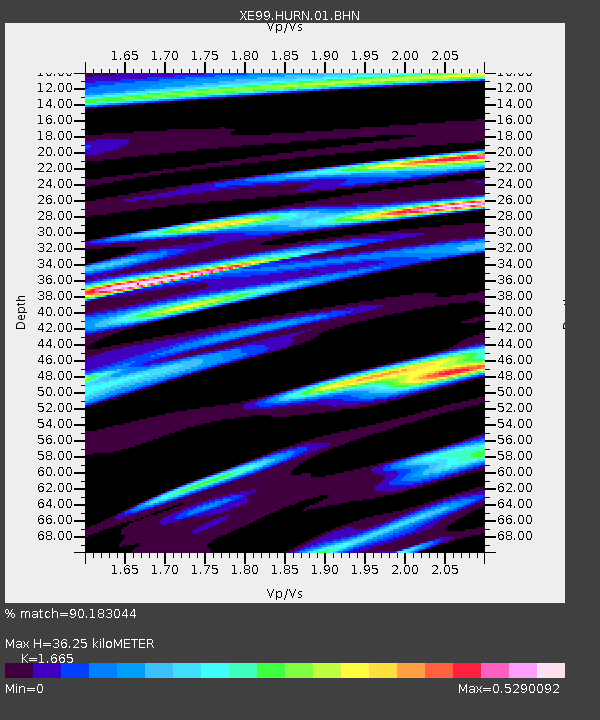
| Estimated Moho Depth: |
36.25 km |
| Estimated Crust Vp/Vs: |
1.66 |
| Assumed Crust Vp: |
6.566 km/s |
| Estimated Crust Vs: |
3.944 km/s |
| Estimated Crust Poisson's Ratio: |
0.22 |
|
| Radial Match: |
90.183044 % |
| Radial Bump: |
342 |
| Transverse Match: |
84.91472 % |
| Transverse Bump: |
400 |
| SOD ConfigId: |
4714 |
| Insert Time: |
2010-03-09 14:19:20.789 +0000 |
| GWidth: |
2.5 |
| Max Bumps: |
400 |
| Tol: |
0.001 |
|

Signal To Noise
| Channel | StoN | STA | LTA |
| XE:HURN:01:BHN:20010428T05:01:11.833015Z | 9.919091 | 1.3169154E-6 | 1.3276573E-7 |
| XE:HURN:01:BHE:20010428T05:01:11.833015Z | 8.442778 | 1.1505269E-6 | 1.3627351E-7 |
| XE:HURN:01:BHZ:20010428T05:01:11.833015Z | 31.731121 | 6.057306E-6 | 1.9089481E-7 |
| Arrivals |
| Ps | 3.8 SECOND |
| PpPs | 14 SECOND |
| PsPs/PpSs | 18 SECOND |


