You are here: Home > Network List > XE99 - Broadband Experiment Across Alaskan Range Stations List
> Station MCK McKinley > Earthquake Result Viewer
MCK McKinley - Earthquake Result Viewer
| Earthquake location: |
Mariana Islands Region |
| Earthquake latitude/longitude: |
21.6/143.0 |
| Earthquake time(UTC): |
2001/07/03 (184) 13:10:42 GMT |
| Earthquake Depth: |
290 km |
| Earthquake Magnitude: |
6.0 MB, 6.5 MW, 6.5 MW |
| Earthquake Catalog/Contributor: |
WHDF/NEIC |
|
| Network: |
XE Broadband Experiment Across Alaskan Range |
| Station: |
MCK McKinley |
| Lat/Lon: |
63.73 N/148.94 W |
| Elevation: |
643 m |
|
| Distance: |
61.1 deg |
| Az: |
28.125 deg |
| Baz: |
260.276 deg |
| Ray Param: |
0.06011779 |
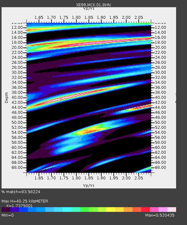
| Estimated Moho Depth: |
40.25 km |
| Estimated Crust Vp/Vs: |
1.74 |
| Assumed Crust Vp: |
6.566 km/s |
| Estimated Crust Vs: |
3.779 km/s |
| Estimated Crust Poisson's Ratio: |
0.25 |
|
| Radial Match: |
83.58224 % |
| Radial Bump: |
400 |
| Transverse Match: |
82.792854 % |
| Transverse Bump: |
400 |
| SOD ConfigId: |
4714 |
| Insert Time: |
2010-03-09 14:20:56.471 +0000 |
| GWidth: |
2.5 |
| Max Bumps: |
400 |
| Tol: |
0.001 |
|

Signal To Noise
| Channel | StoN | STA | LTA |
| XE:MCK:01:BHN:20010703T13:19:55.823999Z | 4.4518704 | 6.3355975E-7 | 1.4231316E-7 |
| XE:MCK:01:BHE:20010703T13:19:55.823999Z | 6.082552 | 6.807157E-7 | 1.1191284E-7 |
| XE:MCK:01:BHZ:20010703T13:19:55.823999Z | 35.344822 | 2.9969506E-6 | 8.4791786E-8 |
| Arrivals |
| Ps | 4.7 SECOND |
| PpPs | 16 SECOND |
| PsPs/PpSs | 21 SECOND |


