
Station XE MCK - McKinley
Network: XE99 - Broadband Experiment Across Alaskan Range
Nearby stations (2 deg radius)
| Station | Name | (Lat, Lon) | Start / End | Elevation |
| MCK | McKinley | (63.73, -148.94) | 1999-05-31 / 2001-12-31 | 643 m |
| Crust2 Type: | L8,thin continental arc, Cordilleras, 0.5 km seds. |
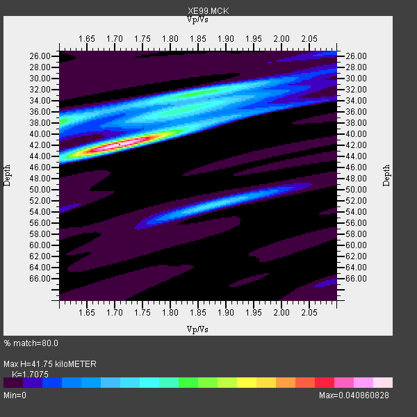
| Thickness Estimate: | 42 km |
| Thickness StdDev: | 0.2 km |
| Vp/Vs Estimate: | 1.71 |
| Vp/Vs StdDev: | 0.01 |
| Vs Estimate: | 3.845 km/s |
| Poisson's Ratio: | 0.24 |
| Peak Value: | 0.04 |
| Assumed Vp: | 6.566 km/s |
| Ps Weight: | 0.33333334 |
| PpPs Weight: | 0.33333334 |
| PsPs Weight: | 0.33333328 |
| Residual Complexity: | 0.617 |
| Nearby stations H: | 42 km +- 0.7 km |
| (2.0 deg) Vp/Vs: | 1.72 +- 0.01 |
9 with match > 90% ( 31.034483 %) and 29 with match > 80% ( 100.0 %) out of 29.
Download stack as xyz text file.
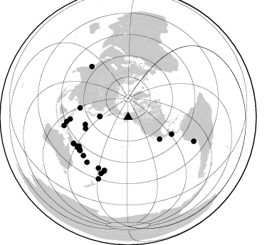
Azimuth Distribution of Events:
Prior Results for this Station
| Study | Thickness | Vp/Vs | Vp | Vs | Poissons Ratio | Extra |
| EARS | 42 km | 1.71 | 6.566 km/s | 3.845 km/s | 0.24 | |
| Crust2.0 | 34 km | 1.77 | 6.566 km/s | 3.707 km/s | 0.27 | L8,thin continental arc, Cordilleras, 0.5 km seds. |
| Global Maxima | 42 km | 1.71 | 6.566 km/s | 3.845 km/s | 0.24 | amp=0.040860828 |
| Local Maxima 1 | 38 km | 1.60 | 6.566 km/s | 4.104 km/s | 0.18 | amp=0.021121865 |
| Local Maxima 2 | 32 km | 1.85 | 6.566 km/s | 3.549 km/s | 0.29 | amp=0.017346635 |
| Local Maxima 3 | 53 km | 1.87 | 6.566 km/s | 3.511 km/s | 0.30 | amp=0.013752584 |
| Local Maxima 4 | 38 km | 1.85 | 6.566 km/s | 3.544 km/s | 0.29 | amp=0.010032694 |
| Predicted Arrivals for vertical incidence (zero ray parameter) | |
| Ps | 4.50 SECOND |
| PpPs | 17.22 SECOND |
| PsPs/PpSs | 21.71 SECOND |
Events Processed for this Station
Download zip of receiver functions as SAC
Plot maxima for each earthquake.
Events Used in the Stack
(29 events)| Radial Match | Distance | Baz | FERegion | Time | Lat/Lon | Depth | Magnitude |
| 94.23457 | 81.4 deg | 268.124 deg | Mindanao, Philippines | 2001/01/01 06:57:04 GMT | (6.9, 126.6) | 33 km | 6.4 MB, 7.2 MS, 7.5 MW, 7.3 ME |
| 94.08408 | 98.1 deg | 110.22 deg | Near Coast Of Peru | 2001/06/23 20:33:14 GMT | (-16.3, -73.6) | 33 km | 6.7 MB, 8.2 MS, 8.4 MW, 7.8 ME |
| 93.82681 | 54.0 deg | 124.865 deg | Near Coast Of Jalisco, Mexico | 2001/05/20 04:21:43 GMT | (18.8, -104.4) | 33 km | 5.5 MB, 6.0 MS, 6.5 MD, 6.3 MW |
| 93.52202 | 65.4 deg | 111.472 deg | El Salvador | 2001/01/13 17:33:32 GMT | (13.0, -88.7) | 60 km | 6.4 MB, 7.8 MS, 7.7 MW, 7.5 ME |
| 92.293816 | 86.6 deg | 265.914 deg | Northern Molucca Sea | 2001/02/24 07:23:48 GMT | (1.3, 126.2) | 35 km | 6.6 MB, 7.0 MS, 7.1 MW, 7.1 ME |
| 92.15656 | 87.9 deg | 324.508 deg | Southern India | 2001/01/26 03:16:40 GMT | (23.4, 70.2) | 16 km | 6.9 MB, 8.0 MS, 7.7 MW, 7.7 ME |
| 92.09063 | 87.9 deg | 205.689 deg | Fiji Islands Region | 2001/07/04 07:06:31 GMT | (-21.7, -176.7) | 185 km | 5.9 MB, 5.8 MS, 6.5 MW, 6.5 MW |
| 91.08723 | 82.8 deg | 239.065 deg | New Britain Region, P.N.G. | 2001/07/08 17:54:18 GMT | (-6.7, 152.1) | 10 km | 6.0 MB, 5.7 MS, 6.2 MW, 5.7 ML |
| 90.71792 | 85.9 deg | 222.34 deg | Vanuatu Islands | 2000/10/04 16:58:44 GMT | (-15.4, 166.9) | 23 km | 6.1 MB, 6.9 MS, 6.8 MW, 6.5 ME |
| 89.30278 | 81.9 deg | 239.818 deg | New Britain Region, P.N.G. | 2000/11/17 21:01:56 GMT | (-5.5, 151.8) | 33 km | 6.2 MB, 8.0 MS, 7.6 MW, 6.9 ME |
| 88.8955 | 39.7 deg | 271.269 deg | Kuril Islands | 2001/05/25 00:40:50 GMT | (44.3, 148.4) | 33 km | 6.1 MB, 6.7 MS, 6.7 MW, 6.6 MW |
| 87.63234 | 82.9 deg | 229.263 deg | Solomon Islands | 2001/05/09 17:38:26 GMT | (-10.3, 161.2) | 68 km | 6.0 MB, 5.9 MS, 6.3 MW, 6.2 MW |
| 86.7203 | 96.0 deg | 205.693 deg | Kermadec Islands, New Zealand | 2001/06/03 02:41:57 GMT | (-29.7, -178.6) | 178 km | 6.8 MB, 7.2 MW, 7.1 MW |
| 86.35829 | 90.8 deg | 262.519 deg | Banda Sea | 2000/08/28 15:05:47 GMT | (-4.1, 127.4) | 16 km | 6.5 MB, 6.8 MS, 6.8 MW, 6.7 ME |
| 86.14009 | 82.8 deg | 210.243 deg | Fiji Islands | 2000/09/14 14:59:57 GMT | (-15.7, 179.8) | 33 km | 5.7 MB, 6.2 MS, 6.3 MW, 6.2 MW |
| 85.445206 | 84.7 deg | 244.079 deg | Eastern New Guinea Reg., P.N.G. | 2001/06/30 16:34:36 GMT | (-6.4, 146.8) | 104 km | 5.8 MB, 6.0 MW, 6.0 MW |
| 84.96528 | 68.8 deg | 280.913 deg | Taiwan | 2000/06/10 18:23:29 GMT | (23.8, 121.2) | 33 km | 6.2 MB, 6.2 MS, 6.4 MW, 6.3 MW |
| 84.546616 | 82.0 deg | 235.244 deg | Solomon Islands | 2001/04/19 20:58:26 GMT | (-7.3, 156.0) | 20 km | 5.7 MB, 6.1 MS, 6.2 MW, 5.9 ME |
| 83.58224 | 61.1 deg | 260.276 deg | Mariana Islands Region | 2001/07/03 13:10:42 GMT | (21.6, 143.0) | 290 km | 6.0 MB, 6.5 MW, 6.5 MW |
| 83.01226 | 83.0 deg | 204.012 deg | Tonga Islands | 2000/09/26 06:17:52 GMT | (-17.2, -173.9) | 56 km | 6.1 MB, 6.1 MS, 6.4 MW, 6.1 ME |
| 82.97387 | 82.1 deg | 236.213 deg | Solomon Islands | 2001/05/29 23:37:19 GMT | (-7.0, 155.0) | 14 km | 5.7 MB, 6.4 MS, 6.4 MW, 5.7 ME |
| 82.85623 | 80.4 deg | 239.435 deg | New Britain Region, P.N.G. | 2000/12/06 22:57:40 GMT | (-4.2, 152.7) | 31 km | 6.1 MB, 6.6 MS, 6.6 MW, 6.2 ME |
| 82.74321 | 85.3 deg | 244.227 deg | Eastern New Guinea Reg., P.N.G. | 2001/06/05 09:00:05 GMT | (-6.9, 146.4) | 10 km | 5.8 MB, 6.2 MS, 6.4 MW, 6.1 MW |
| 82.68419 | 82.3 deg | 236.253 deg | Solomon Islands | 2001/06/01 20:36:56 GMT | (-7.2, 154.9) | 33 km | 5.6 MB, 5.7 MS, 5.9 MW, 5.8 MW |
| 81.87578 | 81.6 deg | 204.034 deg | Tonga Islands | 2000/09/11 17:17:53 GMT | (-15.9, -173.7) | 115 km | 6.0 MB, 6.3 MW, 6.3 MW |
| 80.696465 | 61.9 deg | 255.017 deg | Mariana Islands | 2001/06/15 06:17:45 GMT | (18.8, 147.0) | 33 km | 5.4 MB, 5.9 MS, 6.0 MW, 6.0 MW |
| 80.57196 | 80.4 deg | 239.183 deg | New Britain Region, P.N.G. | 2001/07/01 01:46:06 GMT | (-4.3, 153.0) | 28 km | 5.8 MB, 6.0 MS, 6.1 MW, 6.0 ME |
| 80.36694 | 40.0 deg | 271.378 deg | Kuril Islands | 2001/03/23 11:30:10 GMT | (44.1, 148.1) | 33 km | 5.9 MB, 5.7 MS, 6.0 MW, 5.9 MW |
| 80.19151 | 82.1 deg | 235.299 deg | Solomon Islands | 2001/04/19 21:43:42 GMT | (-7.4, 155.9) | 17 km | 6.0 MB, 6.6 MS, 6.7 MW, 6.2 ME |
Losers
(0 events)| Radial Match | Distance | Baz | FERegion | Time | Lat/Lon | Depth | Magnitude | Reason |
