You are here: Home > Network List > YL01 - Himalayan Nepal Tibet Experiment Stations List
> Station SAJA YL.SAJA > Earthquake Result Viewer
SAJA YL.SAJA - Earthquake Result Viewer
| Earthquake location: |
Northeastern China |
| Earthquake latitude/longitude: |
44.8/129.9 |
| Earthquake time(UTC): |
2002/09/15 (258) 08:39:32 GMT |
| Earthquake Depth: |
586 km |
| Earthquake Magnitude: |
5.8 MB, 6.4 MW, 6.4 MW |
| Earthquake Catalog/Contributor: |
WHDF/NEIC |
|
| Network: |
YL Himalayan Nepal Tibet Experiment |
| Station: |
SAJA YL.SAJA |
| Lat/Lon: |
28.91 N/88.02 E |
| Elevation: |
4351 m |
|
| Distance: |
36.7 deg |
| Az: |
258.764 deg |
| Baz: |
52.749 deg |
| Ray Param: |
0.07355904 |
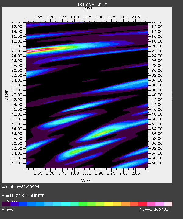
| Estimated Moho Depth: |
22.0 km |
| Estimated Crust Vp/Vs: |
1.60 |
| Assumed Crust Vp: |
6.514 km/s |
| Estimated Crust Vs: |
4.071 km/s |
| Estimated Crust Poisson's Ratio: |
0.18 |
|
| Radial Match: |
82.65006 % |
| Radial Bump: |
400 |
| Transverse Match: |
68.59455 % |
| Transverse Bump: |
400 |
| SOD ConfigId: |
16844 |
| Insert Time: |
2010-02-26 16:10:55.502 +0000 |
| GWidth: |
2.5 |
| Max Bumps: |
400 |
| Tol: |
0.001 |
|
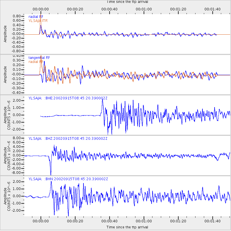
Signal To Noise
| Channel | StoN | STA | LTA |
| YL:SAJA: :BHZ:20020915T08:45:20.390002Z | 3.1990905 | 2.2859487E-7 | 7.145621E-8 |
| YL:SAJA: :BHN:20020915T08:45:20.390002Z | 1.4099154 | 1.07892255E-7 | 7.652392E-8 |
| YL:SAJA: :BHE:20020915T08:45:20.390002Z | 0.76551104 | 5.561094E-8 | 7.2645506E-8 |
| Arrivals |
| Ps | 2.2 SECOND |
| PpPs | 8.1 SECOND |
| PsPs/PpSs | 10 SECOND |


