
Station YL SAJA - YL.SAJA
Network: YL01 - Himalayan Nepal Tibet Experiment
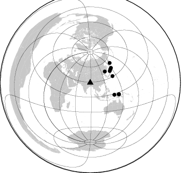
Nearby stations (2 deg radius)
| Station | Name | (Lat, Lon) | Start / End | Elevation |
| SAJA | YL.SAJA | (28.91, 88.02) | 2001-09-07 / 2003-01-01 | 4351 m |
| Crust2 Type: | RD,orogen/70km Tibet, no seds. |
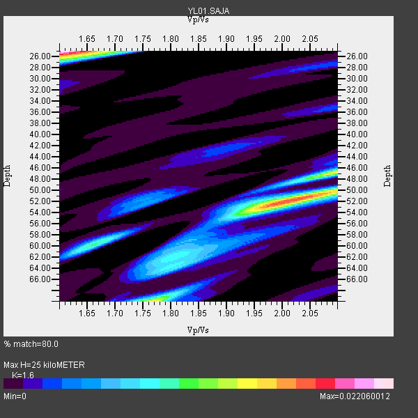
| Thickness Estimate: | 25 km |
| Thickness StdDev: | 17 km |
| Vp/Vs Estimate: | 1.60 |
| Vp/Vs StdDev: | 0.20 |
| Vs Estimate: | 4.071 km/s |
| Poisson's Ratio: | 0.18 |
| Peak Value: | 0.02 |
| Assumed Vp: | 6.514 km/s |
| Ps Weight: | 0.33333334 |
| PpPs Weight: | 0.33333334 |
| PsPs Weight: | 0.33333328 |
| Residual Complexity: | 0.913 |
| Nearby stations H: | +- |
| (2.0 deg) Vp/Vs: | +- |
3 with match > 90% ( 12.0 %) and 10 with match > 80% ( 40.0 %) out of 25.
Download stack as xyz text file.
Azimuth Distribution of Events:
Prior Results for this Station
| Study | Thickness | Vp/Vs | Vp | Vs | Poissons Ratio | Extra |
| EARS | 25 km | 1.60 | 6.514 km/s | 4.071 km/s | 0.18 | |
| Crust2.0 | 70 km | 1.76 | 6.514 km/s | 3.706 km/s | 0.26 | RD,orogen/70km Tibet, no seds. |
| Global Maxima | 25 km | 1.60 | 6.514 km/s | 4.071 km/s | 0.18 | amp=0.022060012 |
| Local Maxima 1 | 52 km | 2.00 | 6.514 km/s | 3.253 km/s | 0.33 | amp=0.017618287 |
| Local Maxima 2 | 70 km | 1.77 | 6.514 km/s | 3.675 km/s | 0.27 | amp=0.014065821 |
| Local Maxima 3 | 47 km | 2.09 | 6.514 km/s | 3.113 km/s | 0.35 | amp=0.010808622 |
| Local Maxima 4 | 60 km | 1.65 | 6.514 km/s | 3.942 km/s | 0.21 | amp=0.008868849 |
| Predicted Arrivals for vertical incidence (zero ray parameter) | |
| Ps | 2.30 SECOND |
| PpPs | 9.98 SECOND |
| PsPs/PpSs | 12.28 SECOND |
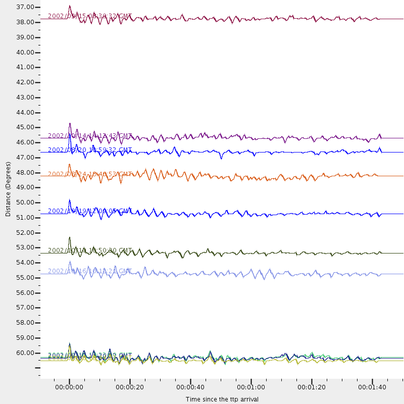
Events Processed for this Station
Download zip of receiver functions as SAC
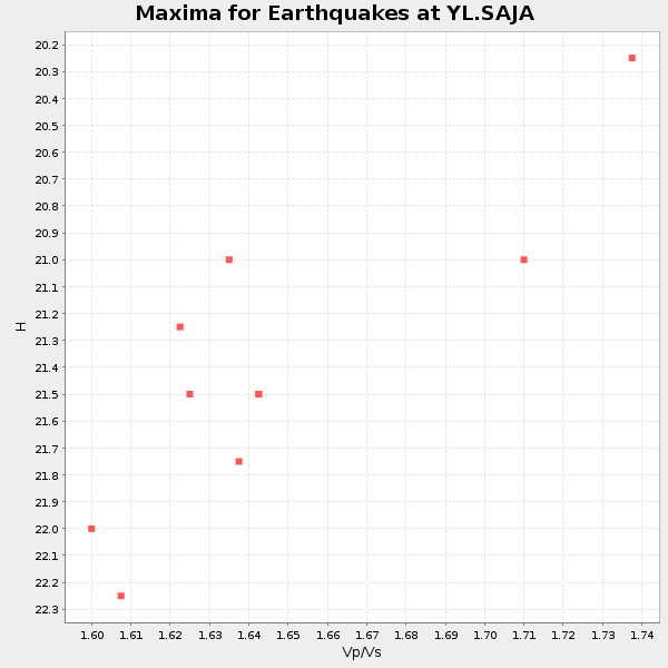
Plot maxima for each earthquake.
Events Used in the Stack
(10 events)| Radial Match | Distance | Baz | FERegion | Time | Lat/Lon | Depth | Magnitude |
| 94.87437 | 61.6 deg | 111.757 deg | Near N Coast Of New Guinea, P.N.G. | 2002/09/08 18:44:23 GMT | (-3.3, 142.9) | 13 km | 6.5 MB, 7.8 MS, 7.6 MW, 7.3 MW |
| 92.44325 | 53.8 deg | 116.425 deg | Irian Jaya Region, Indonesia | 2002/10/10 10:50:20 GMT | (-1.8, 134.3) | 10 km | 6.5 MB, 7.7 MS, 7.6 MW, 7.4 MW |
| 92.33066 | 46.4 deg | 73.47 deg | Southeast Of Honshu, Japan | 2002/08/20 10:59:32 GMT | (31.0, 142.0) | 9.0 km | 5.4 MB, 6.2 MS, 6.3 MW, 6.1 MW |
| 86.41536 | 61.5 deg | 111.856 deg | Near N Coast Of New Guinea, P.N.G. | 2002/09/17 11:20:23 GMT | (-3.3, 142.8) | 10 km | 5.7 MB, 5.9 MS, 6.1 MW, 6.0 MW |
| 85.520676 | 50.9 deg | 54.755 deg | Kuril Islands | 2002/10/19 12:09:05 GMT | (44.3, 150.0) | 33 km | 5.4 MB, 6.2 MS, 6.4 MW, 6.1 MW |
| 83.49101 | 61.4 deg | 111.942 deg | Near N Coast Of New Guinea, P.N.G. | 2002/09/16 13:23:00 GMT | (-3.3, 142.7) | 10 km | 5.9 MB, 5.9 MS, 6.3 MW, 6.1 MW |
| 82.65006 | 36.7 deg | 52.749 deg | Northeastern China | 2002/09/15 08:39:32 GMT | (44.8, 129.9) | 586 km | 5.8 MB, 6.4 MW, 6.4 MW |
| 82.33244 | 48.2 deg | 56.539 deg | Kuril Islands | 2002/08/24 18:40:53 GMT | (43.1, 146.1) | 43 km | 5.9 MB, 5.8 MS, 6.2 MW, 6.1 MW |
| 81.09858 | 45.4 deg | 59.362 deg | Hokkaido, Japan Region | 2002/10/14 14:12:43 GMT | (41.2, 142.2) | 61 km | 5.9 MB, 6.1 MW, 6.1 MW |
| 81.07047 | 55.3 deg | 44.777 deg | Near East Coast Of Kamchatka | 2002/10/16 10:12:21 GMT | (52.0, 157.3) | 102 km | 6.1 MB, 6.2 MW, 6.2 MW |
Losers
(15 events)| Radial Match | Distance | Baz | FERegion | Time | Lat/Lon | Depth | Magnitude | Reason |
| 77.03815 | 45.0 deg | 139.39 deg | Bali Sea | 2002/10/03 19:05:10 GMT | (-7.5, 115.7) | 316 km | 6.0 MB, 6.0 MW, 6.0 MW | |
| 76.93574 | 64.2 deg | 252.141 deg | Lake Tanganyika Region | 2002/10/24 06:08:37 GMT | (-1.9, 29.0) | 11 km | 5.9 MB, 6.3 MS, 6.2 MW, 6.1 MW | |
| 70.36603 | 44.2 deg | 76.578 deg | Southeast Of Honshu, Japan | 2002/08/02 23:11:39 GMT | (29.3, 139.0) | 426 km | 5.5 MB, 6.3 MW, 6.3 MW | |
| 65.94562 | 80.7 deg | 107.557 deg | Solomon Islands | 2002/09/24 23:01:28 GMT | (-10.6, 161.2) | 19 km | 5.7 MB, 6.5 MS, 6.3 MW, 6.3 MW | |
| 65.0025 | 53.7 deg | 116.399 deg | Irian Jaya Region, Indonesia | 2002/09/20 15:43:35 GMT | (-1.7, 134.2) | 10 km | 5.9 MB, 6.4 MS, 6.4 MW, 6.3 MW | |
| 64.47395 | 53.7 deg | 116.438 deg | Irian Jaya Region, Indonesia | 2002/10/10 11:05:15 GMT | (-1.7, 134.2) | 10 km | 5.5 MB | |
| 62.199543 | 39.3 deg | 151.578 deg | Sunda Strait, Indonesia | 2002/08/26 14:55:13 GMT | (-6.8, 105.7) | 63 km | 5.6 MB, 5.8 MW, 5.7 MW | |
| 60.73787 | 91.6 deg | 110.414 deg | Vanuatu Islands | 2002/10/07 19:00:31 GMT | (-18.7, 169.3) | 246 km | 5.4 MB, 5.7 MW, 5.6 MW | |
| 56.442703 | 66.4 deg | 108.309 deg | Bismarck Sea | 2002/10/31 01:35:16 GMT | (-3.4, 148.6) | 10 km | 5.3 MB, 6.0 MS, 6.1 MW, 6.0 MW | |
| 54.382473 | 53.8 deg | 124.07 deg | Banda Sea | 2002/07/30 20:02:06 GMT | (-6.5, 130.3) | 103 km | 5.5 MW, 5.4 MB, 5.3 MW | |
| 50.727924 | 53.4 deg | 116.297 deg | Irian Jaya Region, Indonesia | 2002/10/10 21:19:58 GMT | (-1.5, 134.1) | 10 km | 5.8 MB, 5.7 MS, 6.0 MW | |
| 48.89564 | 64.0 deg | 109.998 deg | Near N Coast Of New Guinea, P.N.G. | 2002/08/29 05:36:54 GMT | (-3.4, 145.8) | 33 km | 5.7 MS, 5.2 MB, 5.9 MW, 5.8 MW | |
| 47.990482 | 55.9 deg | 116.747 deg | Irian Jaya Region, Indonesia | 2002/08/24 20:21:29 GMT | (-3.3, 135.8) | 33 km | 5.5 MB, 5.5 MS, 5.8 MW, 5.7 MW | |
| 47.9816 | 48.1 deg | 137.547 deg | Sumbawa Region, Indonesia | 2002/07/24 03:05:05 GMT | (-9.3, 118.6) | 29 km | 5.8 MB, 5.4 MS, 5.9 MW, 5.9 MW | |
| 46.289364 | 70.6 deg | 179.717 deg | Southeast Indian Ridge | 2002/10/08 01:23:58 GMT | (-42.0, 88.4) | 10 km | 5.3 MB, 5.7 MS, 6.0 MW, 5.9 MW |
