SAJA YL.SAJA - Earthquake Result Viewer
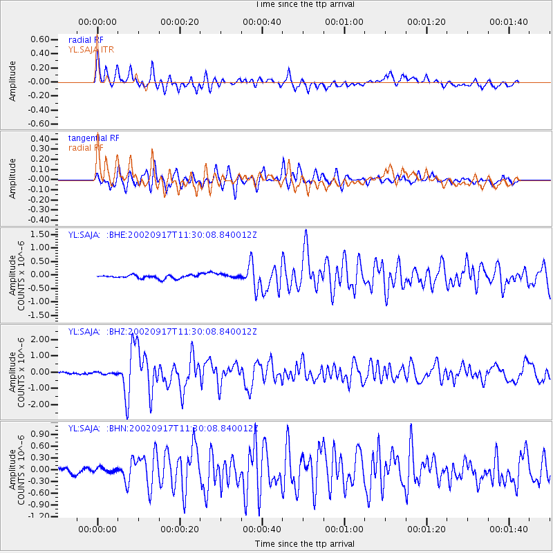
Earthquake location: Near N Coast Of New Guinea, P.N.G.
Earthquake latitude/longitude: -3.3/142.8
Earthquake time(UTC): 2002/09/17 (260) 11:20:23 GMT
Earthquake Depth: 10 km
Earthquake Magnitude: 5.7 MB, 5.9 MS, 6.1 MW, 6.0 MW
Earthquake Catalog/Contributor: WHDF/NEIC
Network: YL Himalayan Nepal Tibet Experiment
Station: SAJA YL.SAJA
Lat/Lon: 28.91 N/88.02 E
Elevation: 4351 m
Distance: 61.5 deg
Az: 305.407 deg
Baz: 111.856 deg
Ray Param: 0.060862433
Estimated Moho Depth: 21.25 km
Estimated Crust Vp/Vs: 1.62
Assumed Crust Vp: 6.514 km/s
Estimated Crust Vs: 4.015 km/s
Estimated Crust Poisson's Ratio: 0.19
Radial Match: 86.41536 %
Radial Bump: 400
Transverse Match: 85.98492 %
Transverse Bump: 400
SOD ConfigId: 16844
Insert Time: 2010-02-26 16:10:58.011 +0000
GWidth: 2.5
Max Bumps: 400
Tol: 0.001

Signal To Noise

ChannelStoNSTALTA
YL:SAJA: :BHZ:20020917T11:30:08.840012Z1.32057656.165341E-84.6686736E-8
YL:SAJA: :BHN:20020917T11:30:08.840012Z0.86789586.269604E-87.2239125E-8
YL:SAJA: :BHE:20020917T11:30:08.840012Z1.10997276.86114E-86.1813594E-8
Arrivals
Ps2.1 SECOND
PpPs8.1 SECOND
PsPs/PpSs10 SECOND