You are here: Home > Network List > YL01 - Himalayan Nepal Tibet Experiment Stations List
> Station SAJA YL.SAJA > Earthquake Result Viewer
SAJA YL.SAJA - Earthquake Result Viewer
| Earthquake location: |
Near East Coast Of Kamchatka |
| Earthquake latitude/longitude: |
52.0/157.3 |
| Earthquake time(UTC): |
2002/10/16 (289) 10:12:21 GMT |
| Earthquake Depth: |
102 km |
| Earthquake Magnitude: |
6.1 MB, 6.2 MW, 6.2 MW |
| Earthquake Catalog/Contributor: |
WHDF/NEIC |
|
| Network: |
YL Himalayan Nepal Tibet Experiment |
| Station: |
SAJA YL.SAJA |
| Lat/Lon: |
28.91 N/88.02 E |
| Elevation: |
4351 m |
|
| Distance: |
55.3 deg |
| Az: |
273.784 deg |
| Baz: |
44.777 deg |
| Ray Param: |
0.06458421 |
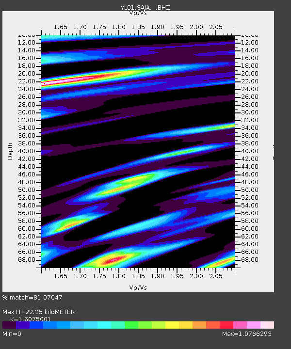
| Estimated Moho Depth: |
22.25 km |
| Estimated Crust Vp/Vs: |
1.61 |
| Assumed Crust Vp: |
6.514 km/s |
| Estimated Crust Vs: |
4.052 km/s |
| Estimated Crust Poisson's Ratio: |
0.18 |
|
| Radial Match: |
81.07047 % |
| Radial Bump: |
358 |
| Transverse Match: |
82.53814 % |
| Transverse Bump: |
380 |
| SOD ConfigId: |
16844 |
| Insert Time: |
2010-02-26 16:10:59.681 +0000 |
| GWidth: |
2.5 |
| Max Bumps: |
400 |
| Tol: |
0.001 |
|

Signal To Noise
| Channel | StoN | STA | LTA |
| YL:SAJA: :BHZ:20021016T10:21:13.58802Z | 33.105247 | 1.6194343E-6 | 4.891775E-8 |
| YL:SAJA: :BHN:20021016T10:21:13.58802Z | 7.7984843 | 4.3609583E-7 | 5.592059E-8 |
| YL:SAJA: :BHE:20021016T10:21:13.58802Z | 9.657109 | 3.8801232E-7 | 4.017893E-8 |
| Arrivals |
| Ps | 2.2 SECOND |
| PpPs | 8.4 SECOND |
| PsPs/PpSs | 11 SECOND |


