You are here: Home > Network List > YL01 - Himalayan Nepal Tibet Experiment Stations List
> Station SAJA YL.SAJA > Earthquake Result Viewer
SAJA YL.SAJA - Earthquake Result Viewer
| Earthquake location: |
Hokkaido, Japan Region |
| Earthquake latitude/longitude: |
41.2/142.2 |
| Earthquake time(UTC): |
2002/10/14 (287) 14:12:43 GMT |
| Earthquake Depth: |
61 km |
| Earthquake Magnitude: |
5.9 MB, 6.1 MW, 6.1 MW |
| Earthquake Catalog/Contributor: |
WHDF/NEIC |
|
| Network: |
YL Himalayan Nepal Tibet Experiment |
| Station: |
SAJA YL.SAJA |
| Lat/Lon: |
28.91 N/88.02 E |
| Elevation: |
4351 m |
|
| Distance: |
45.4 deg |
| Az: |
272.168 deg |
| Baz: |
59.362 deg |
| Ray Param: |
0.071126625 |
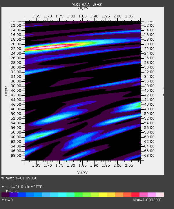
| Estimated Moho Depth: |
21.0 km |
| Estimated Crust Vp/Vs: |
1.71 |
| Assumed Crust Vp: |
6.514 km/s |
| Estimated Crust Vs: |
3.81 km/s |
| Estimated Crust Poisson's Ratio: |
0.24 |
|
| Radial Match: |
81.09858 % |
| Radial Bump: |
400 |
| Transverse Match: |
73.7551 % |
| Transverse Bump: |
400 |
| SOD ConfigId: |
16844 |
| Insert Time: |
2010-02-26 16:11:02.980 +0000 |
| GWidth: |
2.5 |
| Max Bumps: |
400 |
| Tol: |
0.001 |
|

Signal To Noise
| Channel | StoN | STA | LTA |
| YL:SAJA: :BHZ:20021014T14:20:25.664001Z | 7.765866 | 6.333479E-7 | 8.155535E-8 |
| YL:SAJA: :BHN:20021014T14:20:25.664001Z | 1.0824435 | 3.1051388E-7 | 2.8686384E-7 |
| YL:SAJA: :BHE:20021014T14:20:25.664001Z | 2.519366 | 2.092112E-7 | 8.304121E-8 |
| Arrivals |
| Ps | 2.4 SECOND |
| PpPs | 8.2 SECOND |
| PsPs/PpSs | 11 SECOND |


