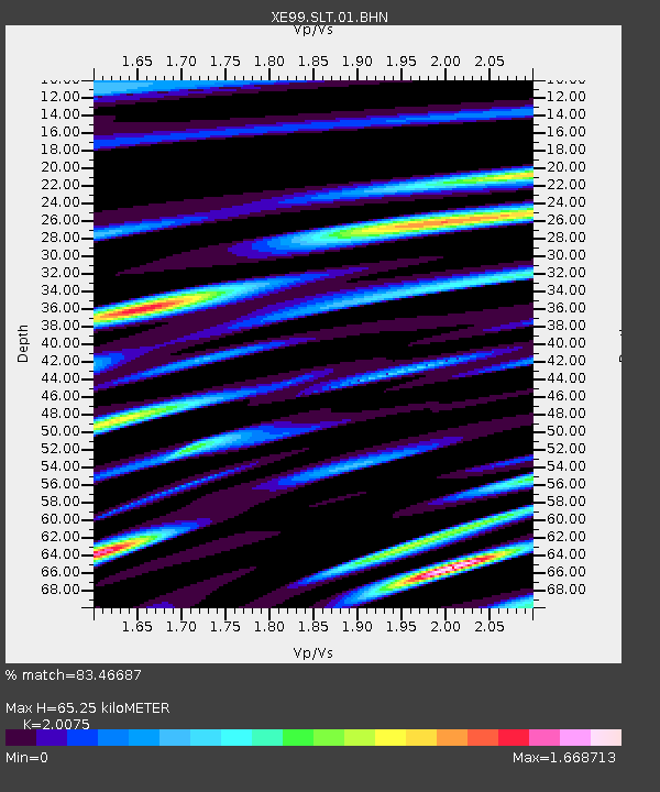
SLT Slate Creek - Earthquake Result Viewer

Earthquake location: Fiji Islands Region
Earthquake latitude/longitude: -21.7/-176.7
Earthquake time(UTC): 2001/07/04 (185) 07:06:31 GMT
Earthquake Depth: 185 km
Earthquake Magnitude: 5.9 MB, 5.8 MS, 6.5 MW, 6.5 MW
Earthquake Catalog/Contributor: WHDF/NEIC
Network: XE Broadband Experiment Across Alaskan Range
Station: SLT Slate Creek
Lat/Lon: 63.94 N/149.12 W
Elevation: 465 m
Distance: 88.1 deg
Az: 11.809 deg
Baz: 205.518 deg
Ray Param: 0.042442344
Estimated Moho Depth: 65.25 km
Estimated Crust Vp/Vs: 2.01
Assumed Crust Vp: 6.566 km/s
Estimated Crust Vs: 3.271 km/s
Estimated Crust Poisson's Ratio: 0.33
Radial Match: 83.46687 %
Radial Bump: 400
Transverse Match: 74.365456 %
Transverse Bump: 400
SOD ConfigId: 4714
Insert Time: 2010-03-09 14:28:04.399 +0000
GWidth: 2.5
Max Bumps: 400
Tol: 0.001

Signal To Noise

ChannelStoNSTALTA
XE:SLT:01:BHN:20010704T07:18:29.74502Z3.08641089.28992E-73.009943E-7
XE:SLT:01:BHE:20010704T07:18:29.74502Z2.30415345.293025E-72.2971669E-7
XE:SLT:01:BHZ:20010704T07:18:29.74502Z19.21272.4576975E-61.2792046E-7
Arrivals
Ps10 SECOND
PpPs29 SECOND
PsPs/PpSs40 SECOND