
Station XE SLT - Slate Creek
Network: XE99 - Broadband Experiment Across Alaskan Range
Nearby stations (2 deg radius)

| Station | Name | (Lat, Lon) | Start / End | Elevation |
| SLT | Slate Creek | (63.94, -149.12) | 2000-05-26 / 2001-12-31 | 465 m |
| Crust2 Type: | L8,thin continental arc, Cordilleras, 0.5 km seds. |
| Thickness Estimate: | 35 km |
| Thickness StdDev: | 9.6 km |
| Vp/Vs Estimate: | 1.72 |
| Vp/Vs StdDev: | 0.16 |
| Vs Estimate: | 3.818 km/s |
| Poisson's Ratio: | 0.24 |
| Peak Value: | 0.04 |
| Assumed Vp: | 6.566 km/s |
| Ps Weight: | 0.33333334 |
| PpPs Weight: | 0.33333334 |
| PsPs Weight: | 0.33333328 |
| Residual Complexity: | 0.634 |
| Nearby stations H: | +- |
| (2.0 deg) Vp/Vs: | +- |
2 with match > 90% ( 50.0 %) and 4 with match > 80% ( 100.0 %) out of 4.
Download stack as xyz text file.
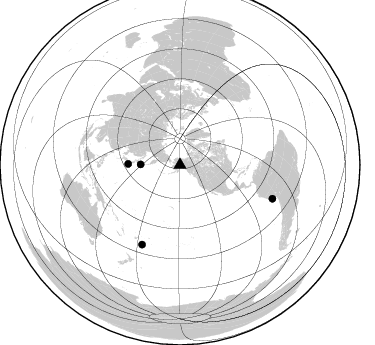
Azimuth Distribution of Events:
Prior Results for this Station
| Study | Thickness | Vp/Vs | Vp | Vs | Poissons Ratio | Extra |
| EARS | 35 km | 1.72 | 6.566 km/s | 3.818 km/s | 0.24 | |
| Crust2.0 | 34 km | 1.77 | 6.566 km/s | 3.707 km/s | 0.27 | L8,thin continental arc, Cordilleras, 0.5 km seds. |
| Global Maxima | 35 km | 1.72 | 6.566 km/s | 3.818 km/s | 0.24 | amp=0.039259065 |
| Local Maxima 1 | 41 km | 1.75 | 6.566 km/s | 3.757 km/s | 0.26 | amp=0.028633095 |
| Local Maxima 2 | 26 km | 1.96 | 6.566 km/s | 3.359 km/s | 0.32 | amp=0.019933563 |
| Local Maxima 3 | 27 km | 2.10 | 6.566 km/s | 3.13 km/s | 0.35 | amp=0.014594138 |
| Local Maxima 4 | 32 km | 1.87 | 6.566 km/s | 3.507 km/s | 0.30 | amp=0.011578542 |
| Predicted Arrivals for vertical incidence (zero ray parameter) | |
| Ps | 3.84 SECOND |
| PpPs | 14.50 SECOND |
| PsPs/PpSs | 18.34 SECOND |
Events Processed for this Station
Download zip of receiver functions as SAC
Plot maxima for each earthquake.
Events Used in the Stack
(4 events)| Radial Match | Distance | Baz | FERegion | Time | Lat/Lon | Depth | Magnitude |
| 93.22663 | 98.2 deg | 110.031 deg | Near Coast Of Peru | 2001/06/23 20:33:14 GMT | (-16.3, -73.6) | 33 km | 6.7 MB, 8.2 MS, 8.4 MW, 7.8 ME |
| 92.73927 | 52.1 deg | 270.942 deg | Near S. Coast Of Honshu, Japan | 2000/07/08 18:57:44 GMT | (34.1, 139.1) | 10 km | 5.9 MB, 5.6 MS, 6.0 MW, 5.9 MW |
| 83.46687 | 88.1 deg | 205.518 deg | Fiji Islands Region | 2001/07/04 07:06:31 GMT | (-21.7, -176.7) | 185 km | 5.9 MB, 5.8 MS, 6.5 MW, 6.5 MW |
| 81.62204 | 39.6 deg | 270.674 deg | Kuril Islands | 2001/06/24 13:18:51 GMT | (44.2, 148.5) | 33 km | 5.8 MB, 5.7 MS, 6.0 MW |
Losers
(0 events)| Radial Match | Distance | Baz | FERegion | Time | Lat/Lon | Depth | Magnitude | Reason |
