You are here: Home > Network List > XE99 - Broadband Experiment Across Alaskan Range Stations List
> Station TLKY Talkeetna Y > Earthquake Result Viewer
TLKY Talkeetna Y - Earthquake Result Viewer
| Earthquake location: |
D'Entrecasteaux Islands Region |
| Earthquake latitude/longitude: |
-9.3/153.8 |
| Earthquake time(UTC): |
2000/08/14 (227) 22:11:00 GMT |
| Earthquake Depth: |
10 km |
| Earthquake Magnitude: |
5.1 MB, 6.0 MS |
| Earthquake Catalog/Contributor: |
WHDF/NEIC |
|
| Network: |
XE Broadband Experiment Across Alaskan Range |
| Station: |
TLKY Talkeetna Y |
| Lat/Lon: |
62.15 N/150.06 W |
| Elevation: |
129 m |
|
| Distance: |
83.3 deg |
| Az: |
23.104 deg |
| Baz: |
235.551 deg |
| Ray Param: |
0.04626479 |
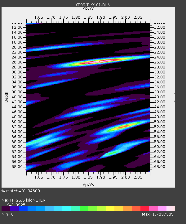
| Estimated Moho Depth: |
25.5 km |
| Estimated Crust Vp/Vs: |
1.89 |
| Assumed Crust Vp: |
6.438 km/s |
| Estimated Crust Vs: |
3.402 km/s |
| Estimated Crust Poisson's Ratio: |
0.31 |
|
| Radial Match: |
81.34588 % |
| Radial Bump: |
400 |
| Transverse Match: |
68.47072 % |
| Transverse Bump: |
400 |
| SOD ConfigId: |
3744 |
| Insert Time: |
2010-03-09 14:28:18.115 +0000 |
| GWidth: |
2.5 |
| Max Bumps: |
400 |
| Tol: |
0.001 |
|

Signal To Noise
| Channel | StoN | STA | LTA |
| XE:TLKY:01:BHN:20000814T22:22:55.621006Z | 1.1621888 | 1.3354054E-7 | 1.14904346E-7 |
| XE:TLKY:01:BHE:20000814T22:22:55.621006Z | 1.1618944 | 1.717388E-7 | 1.4780929E-7 |
| XE:TLKY:01:BHZ:20000814T22:22:55.621006Z | 1.2151835 | 1.1240462E-7 | 9.250012E-8 |
| Arrivals |
| Ps | 3.6 SECOND |
| PpPs | 11 SECOND |
| PsPs/PpSs | 15 SECOND |


