
Station XE TLKY - Talkeetna Y
Network: XE99 - Broadband Experiment Across Alaskan Range
Nearby stations (2 deg radius)
| Station | Name | (Lat, Lon) | Start / End | Elevation |
| TLKY | Talkeetna Y | (62.15, -150.06) | 1999-06-03 / 2001-12-31 | 129 m |
| Crust2 Type: | L2,thin continental arc, Mexico, 2 km seds. |
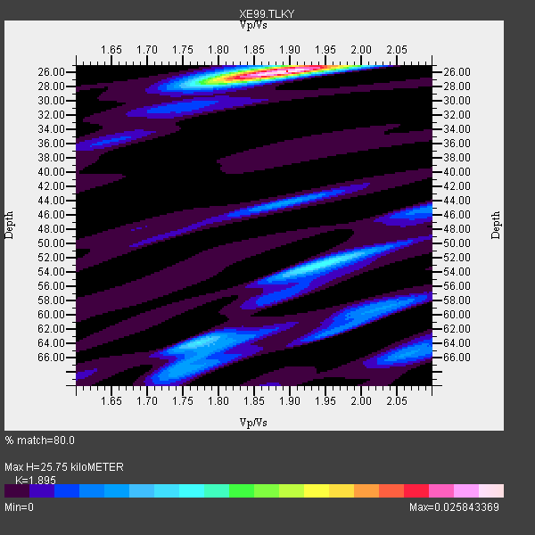
| Thickness Estimate: | 26 km |
| Thickness StdDev: | 13 km |
| Vp/Vs Estimate: | 1.89 |
| Vp/Vs StdDev: | 0.06 |
| Vs Estimate: | 3.397 km/s |
| Poisson's Ratio: | 0.31 |
| Peak Value: | 0.03 |
| Assumed Vp: | 6.438 km/s |
| Ps Weight: | 0.33333334 |
| PpPs Weight: | 0.33333334 |
| PsPs Weight: | 0.33333328 |
| Residual Complexity: | 0.512 |
| Nearby stations H: | +- |
| (2.0 deg) Vp/Vs: | +- |
5 with match > 90% ( 29.411764 %) and 17 with match > 80% ( 100.0 %) out of 17.
Download stack as xyz text file.
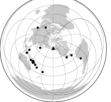
Azimuth Distribution of Events:
Prior Results for this Station
| Study | Thickness | Vp/Vs | Vp | Vs | Poissons Ratio | Extra |
| EARS | 26 km | 1.89 | 6.438 km/s | 3.397 km/s | 0.31 | |
| Crust2.0 | 34 km | 1.78 | 6.438 km/s | 3.624 km/s | 0.27 | L2,thin continental arc, Mexico, 2 km seds. |
| Global Maxima | 26 km | 1.89 | 6.438 km/s | 3.397 km/s | 0.31 | amp=0.025843369 |
| Local Maxima 1 | 53 km | 1.94 | 6.438 km/s | 3.314 km/s | 0.32 | amp=0.010303455 |
| Local Maxima 2 | 64 km | 1.77 | 6.438 km/s | 3.637 km/s | 0.27 | amp=0.007774279 |
| Local Maxima 3 | 44 km | 1.89 | 6.438 km/s | 3.406 km/s | 0.31 | amp=0.0056456495 |
| Local Maxima 4 | 59 km | 2.02 | 6.438 km/s | 3.187 km/s | 0.34 | amp=0.004982431 |
| Predicted Arrivals for vertical incidence (zero ray parameter) | |
| Ps | 3.58 SECOND |
| PpPs | 11.58 SECOND |
| PsPs/PpSs | 15.16 SECOND |
Events Processed for this Station
Download zip of receiver functions as SAC
Plot maxima for each earthquake.
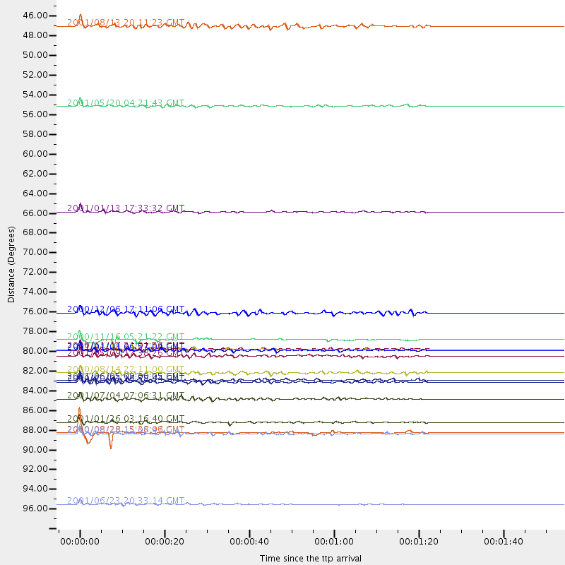
Events Used in the Stack
(17 events)| Radial Match | Distance | Baz | FERegion | Time | Lat/Lon | Depth | Magnitude |
| 95.23605 | 90.0 deg | 261.625 deg | Seram, Indonesia | 2000/08/28 15:38:06 GMT | (-4.0, 127.3) | 10 km | 5.8 MB, 5.8 MS, 6.1 MW |
| 92.97883 | 65.3 deg | 109.708 deg | El Salvador | 2001/01/13 17:33:32 GMT | (13.0, -88.7) | 60 km | 6.4 MB, 7.8 MS, 7.7 MW, 7.5 ME |
| 92.218414 | 88.9 deg | 323.547 deg | Southern India | 2001/01/26 03:16:40 GMT | (23.4, 70.2) | 16 km | 6.9 MB, 8.0 MS, 7.7 MW, 7.7 ME |
| 92.04838 | 98.0 deg | 109.457 deg | Near Coast Of Peru | 2001/06/23 20:33:14 GMT | (-16.3, -73.6) | 33 km | 6.7 MB, 8.2 MS, 8.4 MW, 7.8 ME |
| 91.97692 | 79.7 deg | 237.813 deg | New Ireland Region, P.N.G. | 2000/11/16 05:21:22 GMT | (-5.1, 153.2) | 33 km | 6.0 MB |
| 89.72105 | 84.4 deg | 221.398 deg | Vanuatu Islands | 2000/10/04 16:58:44 GMT | (-15.4, 166.9) | 23 km | 6.1 MB, 6.9 MS, 6.8 MW, 6.5 ME |
| 88.07843 | 80.6 deg | 238.989 deg | New Britain Region, P.N.G. | 2000/11/17 21:01:56 GMT | (-5.5, 151.8) | 33 km | 6.2 MB, 8.0 MS, 7.6 MW, 6.9 ME |
| 86.75759 | 80.8 deg | 234.45 deg | Solomon Islands | 2001/04/19 21:43:42 GMT | (-7.4, 155.9) | 17 km | 6.0 MB, 6.6 MS, 6.7 MW, 6.2 ME |
| 86.739075 | 76.7 deg | 340.49 deg | Turkmenistan | 2000/12/06 17:11:06 GMT | (39.6, 54.8) | 30 km | 6.7 MB, 7.5 MS, 7.0 MW, 6.9 ME |
| 86.56191 | 53.5 deg | 122.689 deg | Near Coast Of Jalisco, Mexico | 2001/05/20 04:21:43 GMT | (18.8, -104.4) | 33 km | 5.5 MB, 6.0 MS, 6.5 MD, 6.3 MW |
| 86.300766 | 80.8 deg | 267.368 deg | Mindanao, Philippines | 2001/01/01 06:57:04 GMT | (6.9, 126.6) | 33 km | 6.4 MB, 7.2 MS, 7.5 MW, 7.3 ME |
| 84.95559 | 81.5 deg | 228.38 deg | Solomon Islands | 2001/05/09 17:38:26 GMT | (-10.3, 161.2) | 68 km | 6.0 MB, 5.9 MS, 6.3 MW, 6.2 MW |
| 82.52997 | 86.3 deg | 204.7 deg | Fiji Islands Region | 2001/07/04 07:06:31 GMT | (-21.7, -176.7) | 185 km | 5.9 MB, 5.8 MS, 6.5 MW, 6.5 MW |
| 82.407326 | 90.1 deg | 261.507 deg | Banda Sea | 2000/08/28 15:05:47 GMT | (-4.1, 127.4) | 16 km | 6.5 MB, 6.8 MS, 6.8 MW, 6.7 ME |
| 81.34588 | 83.3 deg | 235.551 deg | D'Entrecasteaux Islands Region | 2000/08/14 22:11:00 GMT | (-9.3, 153.8) | 10 km | 5.1 MB, 6.0 MS |
| 80.9381 | 44.5 deg | 274.339 deg | Hokkaido, Japan Region | 2001/08/13 20:11:23 GMT | (41.0, 142.3) | 38 km | 6.0 MB, 6.3 MS, 6.4 MW, 6.3 ME |
| 80.73584 | 84.1 deg | 243.339 deg | Eastern New Guinea Reg., P.N.G. | 2001/06/05 09:00:05 GMT | (-6.9, 146.4) | 10 km | 5.8 MB, 6.2 MS, 6.4 MW, 6.1 MW |
Losers
(0 events)| Radial Match | Distance | Baz | FERegion | Time | Lat/Lon | Depth | Magnitude | Reason |
