You are here: Home > Network List > XE99 - Broadband Experiment Across Alaskan Range Stations List
> Station WON Wonder Lake > Earthquake Result Viewer
WON Wonder Lake - Earthquake Result Viewer
| Earthquake location: |
Mariana Islands Region |
| Earthquake latitude/longitude: |
21.6/143.0 |
| Earthquake time(UTC): |
2001/07/03 (184) 13:10:42 GMT |
| Earthquake Depth: |
290 km |
| Earthquake Magnitude: |
6.0 MB, 6.5 MW, 6.5 MW |
| Earthquake Catalog/Contributor: |
WHDF/NEIC |
|
| Network: |
XE Broadband Experiment Across Alaskan Range |
| Station: |
WON Wonder Lake |
| Lat/Lon: |
63.46 N/150.85 W |
| Elevation: |
660 m |
|
| Distance: |
60.2 deg |
| Az: |
28.251 deg |
| Baz: |
258.623 deg |
| Ray Param: |
0.060688544 |
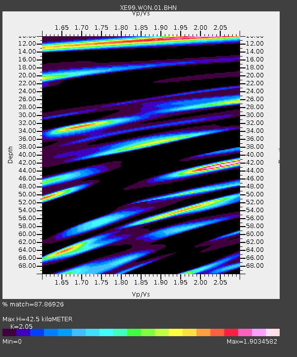
| Estimated Moho Depth: |
42.5 km |
| Estimated Crust Vp/Vs: |
2.05 |
| Assumed Crust Vp: |
6.438 km/s |
| Estimated Crust Vs: |
3.141 km/s |
| Estimated Crust Poisson's Ratio: |
0.34 |
|
| Radial Match: |
87.86926 % |
| Radial Bump: |
340 |
| Transverse Match: |
77.77136 % |
| Transverse Bump: |
342 |
| SOD ConfigId: |
4714 |
| Insert Time: |
2010-03-09 14:29:50.221 +0000 |
| GWidth: |
2.5 |
| Max Bumps: |
400 |
| Tol: |
0.001 |
|

Signal To Noise
| Channel | StoN | STA | LTA |
| XE:WON:01:BHN:20010703T13:19:49.855005Z | 3.9950643 | 4.439115E-7 | 1.11114986E-7 |
| XE:WON:01:BHE:20010703T13:19:49.855005Z | 8.567028 | 8.88269E-7 | 1.0368462E-7 |
| XE:WON:01:BHZ:20010703T13:19:49.855005Z | 25.27566 | 1.2506641E-6 | 4.948097E-8 |
| Arrivals |
| Ps | 7.2 SECOND |
| PpPs | 19 SECOND |
| PsPs/PpSs | 27 SECOND |


