
Station XE WON - Wonder Lake
Network: XE99 - Broadband Experiment Across Alaskan Range
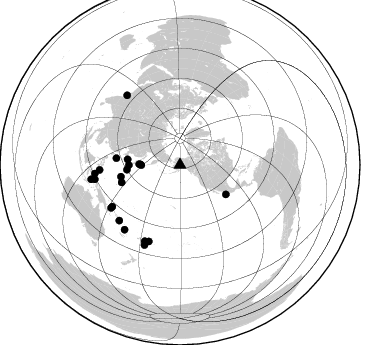
Nearby stations (2 deg radius)
| Station | Name | (Lat, Lon) | Start / End | Elevation |
| WON | Wonder Lake | (63.46, -150.85) | 2000-06-14 / 2001-12-31 | 660 m |
| Crust2 Type: | L2,thin continental arc, Mexico, 2 km seds. |
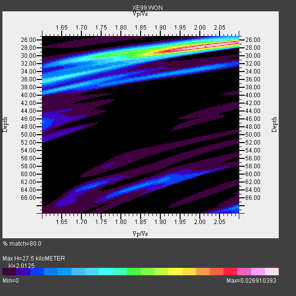
| Thickness Estimate: | 28 km |
| Thickness StdDev: | 7.0 km |
| Vp/Vs Estimate: | 2.01 |
| Vp/Vs StdDev: | 0.12 |
| Vs Estimate: | 3.199 km/s |
| Poisson's Ratio: | 0.34 |
| Peak Value: | 0.03 |
| Assumed Vp: | 6.438 km/s |
| Ps Weight: | 0.33333334 |
| PpPs Weight: | 0.33333334 |
| PsPs Weight: | 0.33333328 |
| Residual Complexity: | 0.469 |
| Nearby stations H: | +- |
| (2.0 deg) Vp/Vs: | +- |
6 with match > 90% ( 27.272728 %) and 22 with match > 80% ( 100.0 %) out of 22.
Download stack as xyz text file.
Azimuth Distribution of Events:
Prior Results for this Station
| Study | Thickness | Vp/Vs | Vp | Vs | Poissons Ratio | Extra |
| EARS | 28 km | 2.01 | 6.438 km/s | 3.199 km/s | 0.34 | |
| Crust2.0 | 34 km | 1.78 | 6.438 km/s | 3.624 km/s | 0.27 | L2,thin continental arc, Mexico, 2 km seds. |
| Global Maxima | 28 km | 2.01 | 6.438 km/s | 3.199 km/s | 0.34 | amp=0.026910393 |
| Local Maxima 1 | 36 km | 1.61 | 6.438 km/s | 4.005 km/s | 0.18 | amp=0.011307974 |
| Local Maxima 2 | 28 km | 1.90 | 6.438 km/s | 3.389 km/s | 0.31 | amp=0.007431581 |
| Local Maxima 3 | 38 km | 1.67 | 6.438 km/s | 3.849 km/s | 0.22 | amp=0.0062559666 |
| Local Maxima 4 | 30 km | 1.85 | 6.438 km/s | 3.49 km/s | 0.29 | amp=0.00534697 |
| Predicted Arrivals for vertical incidence (zero ray parameter) | |
| Ps | 4.32 SECOND |
| PpPs | 12.87 SECOND |
| PsPs/PpSs | 17.19 SECOND |
Events Processed for this Station
Download zip of receiver functions as SAC
Plot maxima for each earthquake.
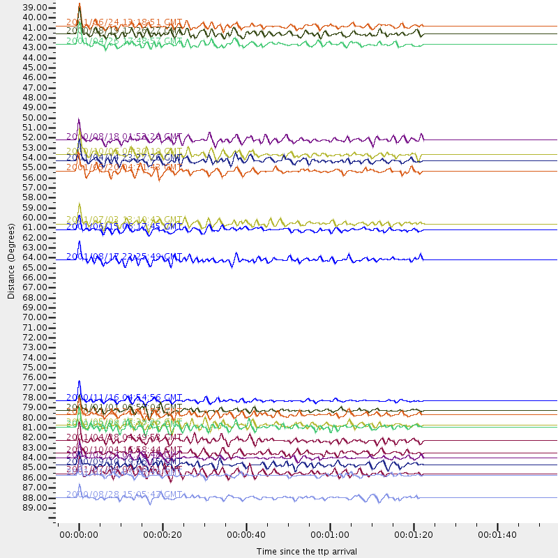
Events Used in the Stack
(22 events)| Radial Match | Distance | Baz | FERegion | Time | Lat/Lon | Depth | Magnitude |
| 93.530975 | 80.5 deg | 266.445 deg | Mindanao, Philippines | 2001/01/01 06:57:04 GMT | (6.9, 126.6) | 33 km | 6.4 MB, 7.2 MS, 7.5 MW, 7.3 ME |
| 92.65219 | 85.7 deg | 264.212 deg | Northern Molucca Sea | 2001/02/24 07:23:48 GMT | (1.3, 126.2) | 35 km | 6.6 MB, 7.0 MS, 7.1 MW, 7.1 ME |
| 92.61617 | 54.6 deg | 122.646 deg | Near Coast Of Jalisco, Mexico | 2001/05/20 04:21:43 GMT | (18.8, -104.4) | 33 km | 5.5 MB, 6.0 MS, 6.5 MD, 6.3 MW |
| 92.33717 | 79.5 deg | 238.295 deg | New Ireland Region, P.N.G. | 2000/11/16 04:54:56 GMT | (-4.0, 152.2) | 33 km | 6.0 MB, 8.2 MS, 8.0 MW, 8.0 ME |
| 91.47473 | 87.6 deg | 322.827 deg | Southern India | 2001/01/26 03:16:40 GMT | (23.4, 70.2) | 16 km | 6.9 MB, 8.0 MS, 7.7 MW, 7.7 ME |
| 90.70243 | 82.4 deg | 202.209 deg | Tonga Islands | 2000/09/26 06:17:52 GMT | (-17.2, -173.9) | 56 km | 6.1 MB, 6.1 MS, 6.4 MW, 6.1 ME |
| 89.6029 | 87.3 deg | 203.946 deg | Fiji Islands Region | 2001/07/04 07:06:31 GMT | (-21.7, -176.7) | 185 km | 5.9 MB, 5.8 MS, 6.5 MW, 6.5 MW |
| 89.29843 | 82.1 deg | 227.5 deg | Solomon Islands | 2001/05/09 17:38:26 GMT | (-10.3, 161.2) | 68 km | 6.0 MB, 5.9 MS, 6.3 MW, 6.2 MW |
| 87.86926 | 60.2 deg | 258.623 deg | Mariana Islands Region | 2001/07/03 13:10:42 GMT | (21.6, 143.0) | 290 km | 6.0 MB, 6.5 MW, 6.5 MW |
| 87.34512 | 39.7 deg | 270.544 deg | Kuril Islands | 2000/08/19 17:26:27 GMT | (43.8, 147.2) | 62 km | 6.0 MB, 5.8 MW, 5.7 MW |
| 87.28782 | 90.0 deg | 260.803 deg | Banda Sea | 2000/08/28 15:05:47 GMT | (-4.1, 127.4) | 16 km | 6.5 MB, 6.8 MS, 6.8 MW, 6.7 ME |
| 87.044945 | 38.8 deg | 269.713 deg | Kuril Islands | 2001/06/24 13:18:51 GMT | (44.2, 148.5) | 33 km | 5.8 MB, 5.7 MS, 6.0 MW |
| 86.90322 | 83.8 deg | 204.882 deg | Fiji Islands Region | 2001/04/28 04:49:53 GMT | (-18.1, -176.9) | 352 km | 6.2 MB, 6.8 MW, 6.8 MW |
| 86.63489 | 81.0 deg | 238.072 deg | New Britain Region, P.N.G. | 2000/11/17 21:01:56 GMT | (-5.5, 151.8) | 33 km | 6.2 MB, 8.0 MS, 7.6 MW, 6.9 ME |
| 86.094 | 86.4 deg | 260.389 deg | Halmahera, Indonesia | 2000/09/10 19:06:15 GMT | (-1.1, 129.3) | 33 km | 5.9 MB, 6.0 MS, 6.1 MW, 6.1 MW |
| 85.9365 | 52.8 deg | 275.988 deg | Western Honshu, Japan | 2000/10/06 04:30:19 GMT | (35.5, 133.1) | 10 km | 5.8 MB, 6.8 MS, 7.0 ME, 6.7 MW |
| 85.20452 | 53.5 deg | 264.733 deg | Southeast Of Honshu, Japan | 2001/04/14 23:27:26 GMT | (30.1, 141.8) | 10 km | 6.0 MB, 5.8 MS, 6.0 MW, 6.0 ME |
| 84.72985 | 85.1 deg | 220.589 deg | Vanuatu Islands | 2000/10/04 16:58:44 GMT | (-15.4, 166.9) | 23 km | 6.1 MB, 6.9 MS, 6.8 MW, 6.5 ME |
| 83.6993 | 40.8 deg | 270.961 deg | Hokkaido, Japan Region | 2001/04/26 17:48:57 GMT | (43.1, 145.9) | 86 km | 5.7 MB, 6.0 MW, 6.0 MW |
| 83.539055 | 51.2 deg | 269.776 deg | Near S. Coast Of Honshu, Japan | 2000/08/18 01:52:20 GMT | (34.1, 139.2) | 10 km | 5.6 MB, 5.5 MS, 5.8 MW, 5.7 MW |
| 83.50523 | 61.0 deg | 253.317 deg | Mariana Islands | 2001/06/15 06:17:45 GMT | (18.8, 147.0) | 33 km | 5.4 MB, 5.9 MS, 6.0 MW, 6.0 MW |
| 81.9315 | 64.2 deg | 276.075 deg | Ryukyu Islands, Japan | 2001/08/17 22:25:49 GMT | (25.7, 126.2) | 33 km | 5.6 MB, 5.6 MS, 5.9 MW, 5.9 MW |
Losers
(0 events)| Radial Match | Distance | Baz | FERegion | Time | Lat/Lon | Depth | Magnitude | Reason |
