You are here: Home > Network List > OE - Austrian Seismic Network Stations List
> Station DAVA Damuels, Vorarlberg, Austria > Earthquake Result Viewer
DAVA Damuels, Vorarlberg, Austria - Earthquake Result Viewer
| Earthquake location: |
Northern Peru |
| Earthquake latitude/longitude: |
-4.5/-76.7 |
| Earthquake time(UTC): |
2021/11/28 (332) 10:52:14 GMT |
| Earthquake Depth: |
99 km |
| Earthquake Magnitude: |
7.4 Mi |
| Earthquake Catalog/Contributor: |
NEIC PDE/at |
|
| Network: |
OE Austrian Seismic Network |
| Station: |
DAVA Damuels, Vorarlberg, Austria |
| Lat/Lon: |
47.29 N/9.88 E |
| Elevation: |
1602 m |
|
| Distance: |
91.0 deg |
| Az: |
42.818 deg |
| Baz: |
264.455 deg |
| Ray Param: |
0.0416331 |
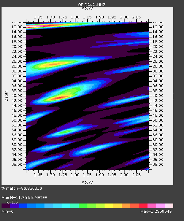
| Estimated Moho Depth: |
11.75 km |
| Estimated Crust Vp/Vs: |
1.60 |
| Assumed Crust Vp: |
6.416 km/s |
| Estimated Crust Vs: |
4.01 km/s |
| Estimated Crust Poisson's Ratio: |
0.18 |
|
| Radial Match: |
86.856316 % |
| Radial Bump: |
400 |
| Transverse Match: |
74.81671 % |
| Transverse Bump: |
400 |
| SOD ConfigId: |
26694651 |
| Insert Time: |
2021-12-12 11:22:53.034 +0000 |
| GWidth: |
2.5 |
| Max Bumps: |
400 |
| Tol: |
0.001 |
|

Signal To Noise
| Channel | StoN | STA | LTA |
| OE:DAVA: :HHZ:20211128T11:04:35.588013Z | 10.976436 | 3.204713E-6 | 2.9196298E-7 |
| OE:DAVA: :HHN:20211128T11:04:35.588013Z | 3.0564513 | 7.0470685E-7 | 2.3056374E-7 |
| OE:DAVA: :HHE:20211128T11:04:35.588013Z | 4.9865923 | 8.816752E-7 | 1.7680915E-7 |
| Arrivals |
| Ps | 1.1 SECOND |
| PpPs | 4.7 SECOND |
| PsPs/PpSs | 5.8 SECOND |


