You are here: Home > Network List > XE94 - BBand Andean Joint Exp. / Seismic Exploration of Deep Andes Stations List
> Station TACA XE.TACA > Earthquake Result Viewer
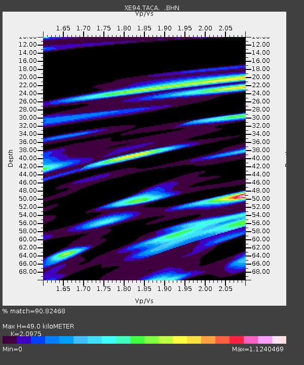
TACA XE.TACA - Earthquake Result Viewer
| Earthquake location: |
Guerrero, Mexico |
| Earthquake latitude/longitude: |
18.2/-101.4 |
| Earthquake time(UTC): |
1994/12/10 (344) 16:17:41 GMT |
| Earthquake Depth: |
67 km |
| Earthquake Magnitude: |
6.5 MB, 6.6 UNKNOWN, 6.5 MW |
| Earthquake Catalog/Contributor: |
WHDF/NEIC |
|
| Network: |
XE BBand Andean Joint Exp. / Seismic Exploration of Deep Andes |
| Station: |
TACA XE.TACA |
| Lat/Lon: |
18.83 S/66.73 W |
| Elevation: |
3810 m |
|
| Distance: |
50.1 deg |
| Az: |
135.489 deg |
| Baz: |
315.298 deg |
| Ray Param: |
0.06805844 |
| Estimated Moho Depth: |
49.0 km |
| Estimated Crust Vp/Vs: |
2.10 |
| Assumed Crust Vp: |
6.319 km/s |
| Estimated Crust Vs: |
3.013 km/s |
| Estimated Crust Poisson's Ratio: |
0.35 |
|
| Radial Match: |
90.82468 % |
| Radial Bump: |
400 |
| Transverse Match: |
74.85467 % |
| Transverse Bump: |
400 |
| SOD ConfigId: |
16938 |
| Insert Time: |
2010-03-09 14:34:23.237 +0000 |
| GWidth: |
2.5 |
| Max Bumps: |
400 |
| Tol: |
0.001 |
|

Signal To Noise
| Channel | StoN | STA | LTA |
| XE:TACA: :BHN:19941210T16:25:59.06601Z | 3.1013327 | 3.9931317E-7 | 1.2875536E-7 |
| XE:TACA: :BHE:19941210T16:25:59.06601Z | 2.403182 | 2.0162943E-7 | 8.390102E-8 |
| XE:TACA: :BHZ:19941210T16:25:59.06601Z | 20.403666 | 1.4774735E-6 | 7.241216E-8 |
| Arrivals |
| Ps | 8.9 SECOND |
| PpPs | 23 SECOND |
| PsPs/PpSs | 32 SECOND |


