
Station XE TACA - XE.TACA
Network: XE94 - BBand Andean Joint Exp. / Seismic Exploration of Deep Andes
Nearby stations (2 deg radius)
| Station | Name | (Lat, Lon) | Start / End | Elevation |
| TACA | XE.TACA | (-18.83, -66.73) | 1994-03-27 / 1995-12-31 | 3810 m |
| Crust2 Type: | RC,orogen/65km Tibet, 4.5 km seds. |
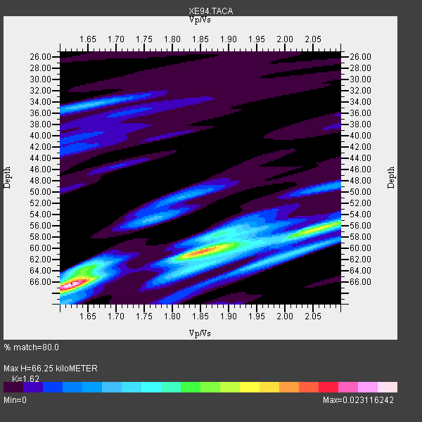
| Thickness Estimate: | 66 km |
| Thickness StdDev: | 4.1 km |
| Vp/Vs Estimate: | 1.62 |
| Vp/Vs StdDev: | 0.17 |
| Vs Estimate: | 3.901 km/s |
| Poisson's Ratio: | 0.19 |
| Peak Value: | 0.02 |
| Assumed Vp: | 6.319 km/s |
| Ps Weight: | 0.33333334 |
| PpPs Weight: | 0.33333334 |
| PsPs Weight: | 0.33333328 |
| Residual Complexity: | 0.709 |
| Nearby stations H: | +- |
| (2.0 deg) Vp/Vs: | +- |
3 with match > 90% ( 27.272728 %) and 7 with match > 80% ( 63.636364 %) out of 11.
Download stack as xyz text file.
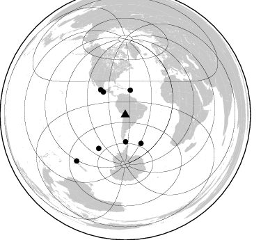
Azimuth Distribution of Events:
Prior Results for this Station
| Study | Thickness | Vp/Vs | Vp | Vs | Poissons Ratio | Extra |
| EARS | 66 km | 1.62 | 6.319 km/s | 3.901 km/s | 0.19 | |
| Crust2.0 | 65 km | 1.76 | 6.319 km/s | 3.593 km/s | 0.26 | RC,orogen/65km Tibet, 4.5 km seds. |
| Global Maxima | 66 km | 1.62 | 6.319 km/s | 3.901 km/s | 0.19 | amp=0.023116242 |
| Local Maxima 1 | 60 km | 1.86 | 6.319 km/s | 3.407 km/s | 0.30 | amp=0.01404724 |
| Local Maxima 2 | 64 km | 1.65 | 6.319 km/s | 3.836 km/s | 0.21 | amp=0.008353391 |
| Local Maxima 3 | 62 km | 1.97 | 6.319 km/s | 3.216 km/s | 0.33 | amp=0.008098024 |
| Local Maxima 4 | 63 km | 1.86 | 6.319 km/s | 3.397 km/s | 0.30 | amp=0.007215088 |
| Predicted Arrivals for vertical incidence (zero ray parameter) | |
| Ps | 6.50 SECOND |
| PpPs | 27.47 SECOND |
| PsPs/PpSs | 33.97 SECOND |
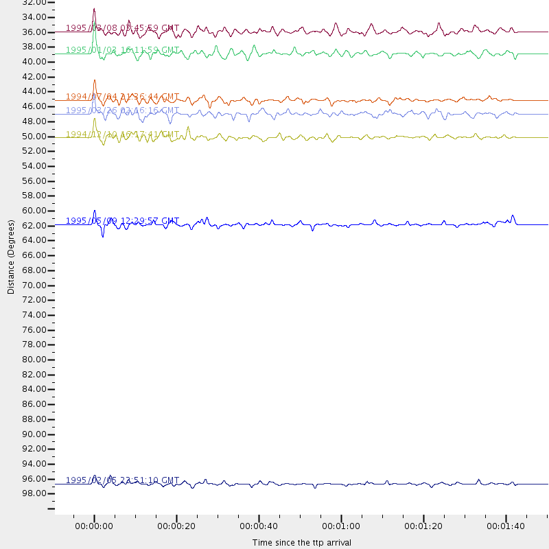
Events Processed for this Station
Download zip of receiver functions as SAC
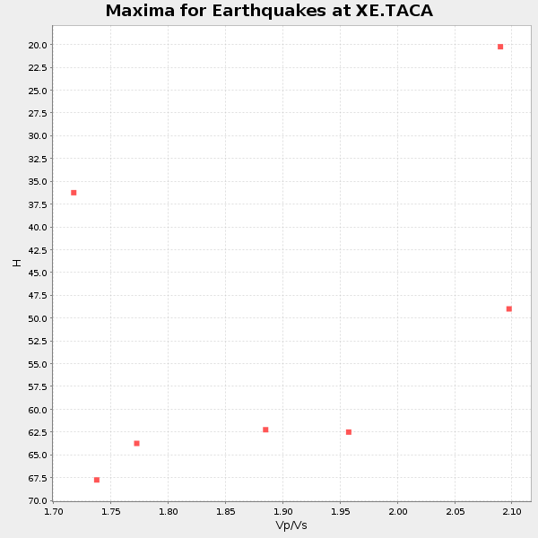
Plot maxima for each earthquake.
Events Used in the Stack
(7 events)| Radial Match | Distance | Baz | FERegion | Time | Lat/Lon | Depth | Magnitude |
| 93.8621 | 45.1 deg | 316.008 deg | Off Coast Of Oaxaca, Mexico | 1994/07/04 21:36:44 GMT | (14.9, -97.3) | 33 km | 6.1 MB, 6.1 MS, 6.5 UNKNOWN, 6.5 MD |
| 92.8182 | 96.7 deg | 226.6 deg | Off E. Coast Of N. Island, N.Z. | 1995/02/05 22:51:10 GMT | (-37.7, 178.8) | 59 km | 6.4 MB, 7.1 UNKNOWN, 7.1 MW |
| 90.82468 | 50.1 deg | 315.298 deg | Guerrero, Mexico | 1994/12/10 16:17:41 GMT | (18.2, -101.4) | 67 km | 6.5 MB, 6.6 UNKNOWN, 6.5 MW |
| 86.78278 | 38.8 deg | 179.336 deg | Drake Passage | 1995/01/03 16:11:59 GMT | (-57.7, -66.0) | 33 km | 6.1 MB, 5.6 MS, 6.1 UNKNOWN, 5.9 MW |
| 84.8165 | 61.8 deg | 218.274 deg | Pacific-Antarctic Ridge | 1995/05/09 12:29:57 GMT | (-54.0, -134.3) | 10 km | 5.4 MB, 5.7 MS, 5.9 UNKNOWN |
| 84.590034 | 46.9 deg | 151.27 deg | South Sandwich Islands Region | 1995/03/26 02:16:16 GMT | (-55.9, -28.2) | 77 km | 6.1 MB, 5.9 MS, 6.4 UNKNOWN, 6.3 MW |
| 80.84836 | 35.9 deg | 11.773 deg | Leeward Islands | 1995/03/08 03:45:59 GMT | (16.6, -59.6) | 15 km | 6.3 MB, 6.2 MS, 6.4 UNKNOWN, 6.1 MD |
Losers
(4 events)| Radial Match | Distance | Baz | FERegion | Time | Lat/Lon | Depth | Magnitude | Reason |
| 74.486465 | 98.1 deg | 237.565 deg | Kermadec Islands Region | 1994/12/17 21:07:57 GMT | (-27.4, -176.8) | 33 km | 5.5 MS, 5.2 MB, 5.2 UNKNOWN, 5.8 MW | |
| 73.79953 | 40.2 deg | 337.702 deg | Caribbean Sea | 1995/06/27 10:09:58 GMT | (18.8, -81.7) | 10 km | 5.7 MB, 5.6 MS, 6.2 UNKNOWN, 6.1 MW | |
| 72.69633 | 98.0 deg | 235.586 deg | Kermadec Islands, New Zealand | 1995/07/03 19:50:50 GMT | (-29.2, -177.6) | 33 km | 6.5 MB, 7.2 MS, 7.2 UNKNOWN, 7.2 MW | |
| 54.49 | 30.0 deg | 326.908 deg | South Of Panama | 1995/02/05 20:37:10 GMT | (6.8, -82.7) | 10 km | 5.8 MB, 5.4 MS, 6.1 UNKNOWN, 5.3 MD |
