You are here: Home > Network List > IC - New China Digital Seismograph Network Stations List
> Station HIA Hailar, Neimenggu Autonomous Region, China > Earthquake Result Viewer
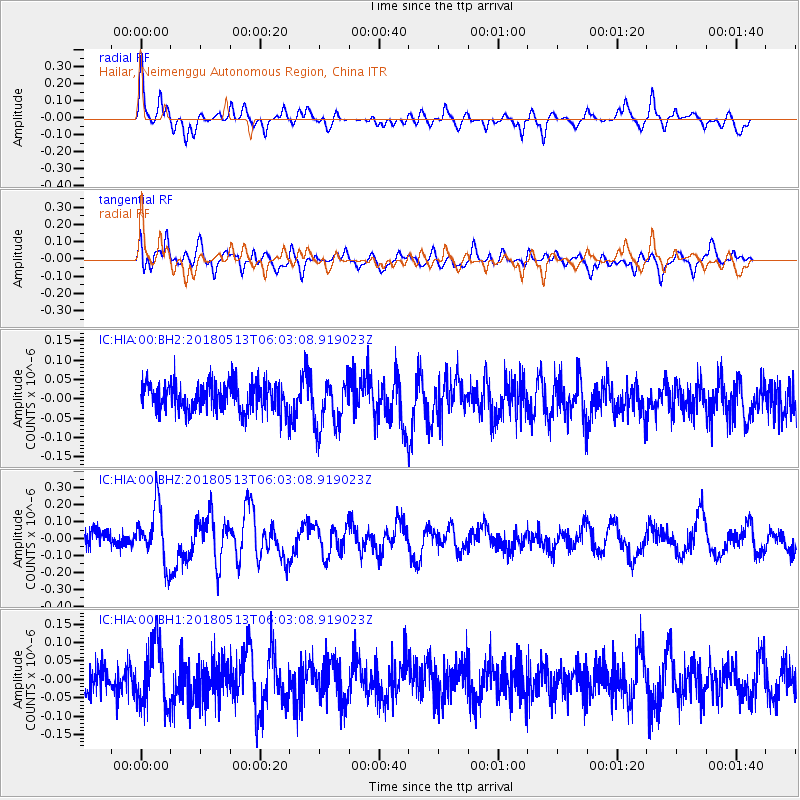
HIA Hailar, Neimenggu Autonomous Region, China - Earthquake Result Viewer
*The percent match for this event was below the threshold and hence no stack was calculated.
| Earthquake location: |
Tonga Islands |
| Earthquake latitude/longitude: |
-21.2/-173.9 |
| Earthquake time(UTC): |
2018/05/13 (133) 05:50:33 GMT |
| Earthquake Depth: |
10 km |
| Earthquake Magnitude: |
5.6 mb |
| Earthquake Catalog/Contributor: |
NEIC PDE/us |
|
| Network: |
IC New China Digital Seismograph Network |
| Station: |
HIA Hailar, Neimenggu Autonomous Region, China |
| Lat/Lon: |
49.27 N/119.74 E |
| Elevation: |
620 m |
|
| Distance: |
91.5 deg |
| Az: |
323.104 deg |
| Baz: |
121.185 deg |
| Ray Param: |
$rayparam |
*The percent match for this event was below the threshold and hence was not used in the summary stack. |
|
| Radial Match: |
69.70197 % |
| Radial Bump: |
400 |
| Transverse Match: |
60.27996 % |
| Transverse Bump: |
400 |
| SOD ConfigId: |
2665671 |
| Insert Time: |
2018-05-27 05:56:23.584 +0000 |
| GWidth: |
2.5 |
| Max Bumps: |
400 |
| Tol: |
0.001 |
|
Signal To Noise
| Channel | StoN | STA | LTA |
| IC:HIA:00:BHZ:20180513T06:03:08.919023Z | 3.0494053 | 1.637342E-7 | 5.369381E-8 |
| IC:HIA:00:BH1:20180513T06:03:08.919023Z | 2.0468695 | 8.267671E-8 | 4.0391786E-8 |
| IC:HIA:00:BH2:20180513T06:03:08.919023Z | 1.7076274 | 6.352233E-8 | 3.7199175E-8 |
| Arrivals |
| Ps | |
| PpPs | |
| PsPs/PpSs | |


