You are here: Home > Network List > IC - New China Digital Seismograph Network Stations List
> Station HIA Hailar, Neimenggu Autonomous Region, China > Earthquake Result Viewer
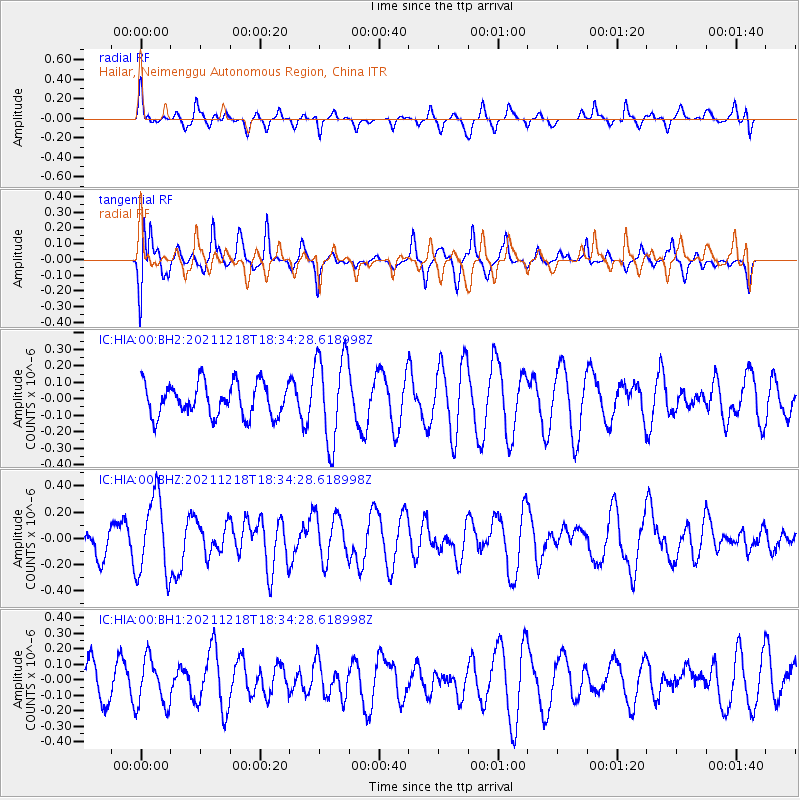
HIA Hailar, Neimenggu Autonomous Region, China - Earthquake Result Viewer
*The percent match for this event was below the threshold and hence no stack was calculated.
| Earthquake location: |
Irian Jaya Region, Indonesia |
| Earthquake latitude/longitude: |
-0.7/131.6 |
| Earthquake time(UTC): |
2021/12/18 (352) 18:25:59 GMT |
| Earthquake Depth: |
10 km |
| Earthquake Magnitude: |
5.2 Mww |
| Earthquake Catalog/Contributor: |
NEIC PDE/us |
|
| Network: |
IC New China Digital Seismograph Network |
| Station: |
HIA Hailar, Neimenggu Autonomous Region, China |
| Lat/Lon: |
49.27 N/119.74 E |
| Elevation: |
620 m |
|
| Distance: |
50.8 deg |
| Az: |
350.03 deg |
| Baz: |
164.675 deg |
| Ray Param: |
$rayparam |
*The percent match for this event was below the threshold and hence was not used in the summary stack. |
|
| Radial Match: |
47.724224 % |
| Radial Bump: |
303 |
| Transverse Match: |
71.80466 % |
| Transverse Bump: |
322 |
| SOD ConfigId: |
26694651 |
| Insert Time: |
2022-01-01 18:31:25.505 +0000 |
| GWidth: |
2.5 |
| Max Bumps: |
400 |
| Tol: |
0.001 |
|
Signal To Noise
| Channel | StoN | STA | LTA |
| IC:HIA:00:BHZ:20211218T18:34:28.618998Z | 2.0689058 | 3.005797E-7 | 1.4528437E-7 |
| IC:HIA:00:BH1:20211218T18:34:28.618998Z | 0.88545096 | 1.5330228E-7 | 1.7313471E-7 |
| IC:HIA:00:BH2:20211218T18:34:28.618998Z | 2.7106986 | 2.699406E-7 | 9.958341E-8 |
| Arrivals |
| Ps | |
| PpPs | |
| PsPs/PpSs | |


