You are here: Home > Network List > IC - New China Digital Seismograph Network Stations List
> Station HIA Hailar, Neimenggu Autonomous Region, China > Earthquake Result Viewer
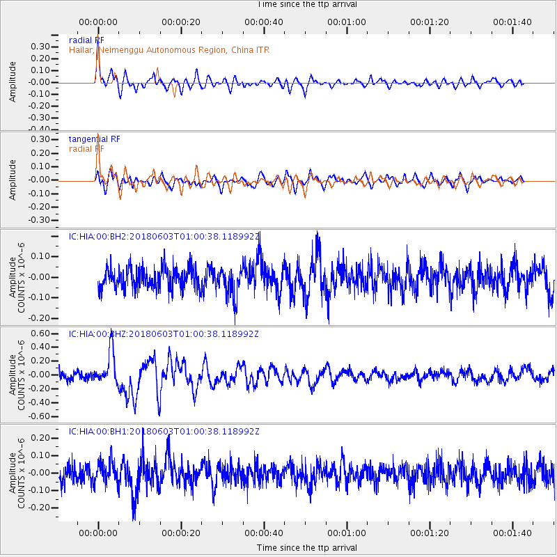
HIA Hailar, Neimenggu Autonomous Region, China - Earthquake Result Viewer
*The percent match for this event was below the threshold and hence no stack was calculated.
| Earthquake location: |
Tonga Islands |
| Earthquake latitude/longitude: |
-19.4/-173.7 |
| Earthquake time(UTC): |
2018/06/03 (154) 00:48:09 GMT |
| Earthquake Depth: |
10 km |
| Earthquake Magnitude: |
5.6 mb |
| Earthquake Catalog/Contributor: |
NEIC PDE/us |
|
| Network: |
IC New China Digital Seismograph Network |
| Station: |
HIA Hailar, Neimenggu Autonomous Region, China |
| Lat/Lon: |
49.27 N/119.74 E |
| Elevation: |
620 m |
|
| Distance: |
90.2 deg |
| Az: |
323.056 deg |
| Baz: |
119.99 deg |
| Ray Param: |
$rayparam |
*The percent match for this event was below the threshold and hence was not used in the summary stack. |
|
| Radial Match: |
69.67534 % |
| Radial Bump: |
390 |
| Transverse Match: |
55.604275 % |
| Transverse Bump: |
400 |
| SOD ConfigId: |
2709371 |
| Insert Time: |
2018-06-17 00:52:15.452 +0000 |
| GWidth: |
2.5 |
| Max Bumps: |
400 |
| Tol: |
0.001 |
|
Signal To Noise
| Channel | StoN | STA | LTA |
| IC:HIA:00:BHZ:20180603T01:00:38.118992Z | 4.855734 | 2.485619E-7 | 5.1189357E-8 |
| IC:HIA:00:BH1:20180603T01:00:38.118992Z | 1.2518771 | 6.031471E-8 | 4.8179416E-8 |
| IC:HIA:00:BH2:20180603T01:00:38.118992Z | 1.4319667 | 7.217738E-8 | 5.0404367E-8 |
| Arrivals |
| Ps | |
| PpPs | |
| PsPs/PpSs | |


