You are here: Home > Network List > IC - New China Digital Seismograph Network Stations List
> Station HIA Hailar, Neimenggu Autonomous Region, China > Earthquake Result Viewer
HIA Hailar, Neimenggu Autonomous Region, China - Earthquake Result Viewer

| Earthquake location: |
Cyprus Region |
| Earthquake latitude/longitude: |
35.1/31.9 |
| Earthquake time(UTC): |
2022/01/11 (011) 01:07:47 GMT |
| Earthquake Depth: |
20 km |
| Earthquake Magnitude: |
6.6 Mww |
| Earthquake Catalog/Contributor: |
NEIC PDE/us |
|
| Network: |
IC New China Digital Seismograph Network |
| Station: |
HIA Hailar, Neimenggu Autonomous Region, China |
| Lat/Lon: |
49.27 N/119.74 E |
| Elevation: |
620 m |
|
| Distance: |
63.0 deg |
| Az: |
47.25 deg |
| Baz: |
293.256 deg |
| Ray Param: |
0.05981356 |
| Estimated Moho Depth: |
37.5 km |
| Estimated Crust Vp/Vs: |
1.71 |
| Assumed Crust Vp: |
6.577 km/s |
| Estimated Crust Vs: |
3.852 km/s |
| Estimated Crust Poisson's Ratio: |
0.24 |
|
| Radial Match: |
98.06886 % |
| Radial Bump: |
318 |
| Transverse Match: |
90.31711 % |
| Transverse Bump: |
400 |
| SOD ConfigId: |
26694651 |
| Insert Time: |
2022-01-25 01:20:37.592 +0000 |
| GWidth: |
2.5 |
| Max Bumps: |
400 |
| Tol: |
0.001 |
|
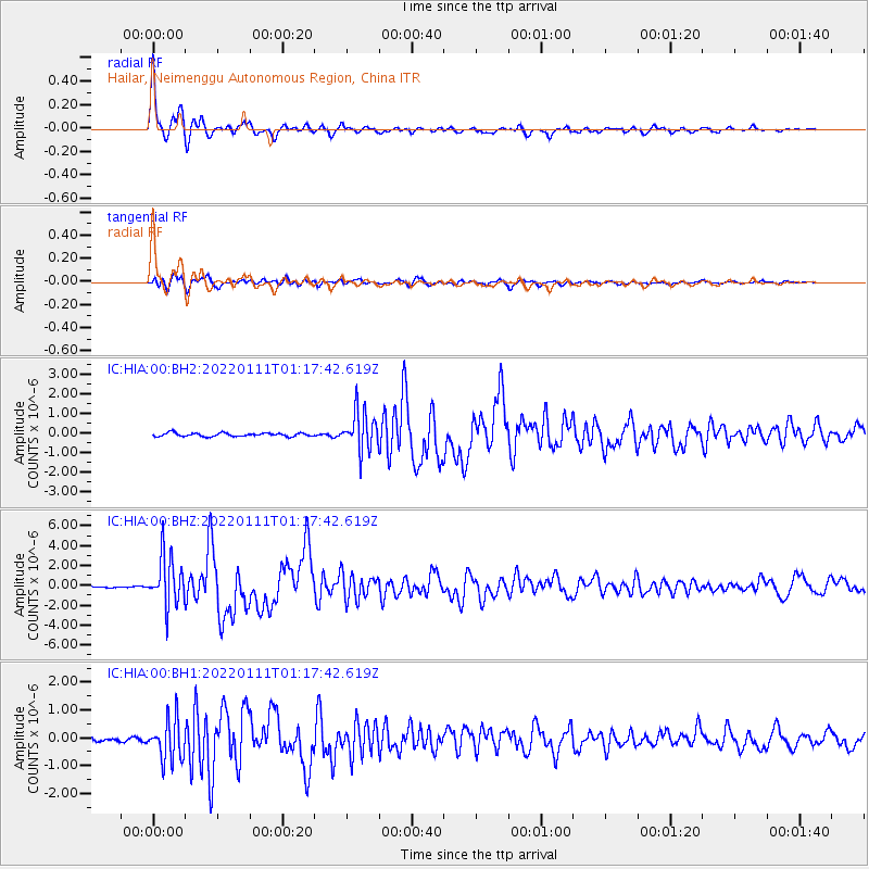
Signal To Noise
| Channel | StoN | STA | LTA |
| IC:HIA:00:BHZ:20220111T01:17:42.619Z | 30.652142 | 2.4830204E-6 | 8.100643E-8 |
| IC:HIA:00:BH1:20220111T01:17:42.619Z | 9.50507 | 7.3968056E-7 | 7.7819585E-8 |
| IC:HIA:00:BH2:20220111T01:17:42.619Z | 11.582689 | 9.963387E-7 | 8.601963E-8 |
| Arrivals |
| Ps | 4.2 SECOND |
| PpPs | 15 SECOND |
| PsPs/PpSs | 19 SECOND |


