You are here: Home > Network List > YL01 - Himalayan Nepal Tibet Experiment Stations List
> Station XIXI YL.XIXI > Earthquake Result Viewer
XIXI YL.XIXI - Earthquake Result Viewer
| Earthquake location: |
Southeast Of Honshu, Japan |
| Earthquake latitude/longitude: |
29.3/139.0 |
| Earthquake time(UTC): |
2002/08/02 (214) 23:11:39 GMT |
| Earthquake Depth: |
426 km |
| Earthquake Magnitude: |
5.5 MB, 6.3 MW, 6.3 MW |
| Earthquake Catalog/Contributor: |
WHDF/NEIC |
|
| Network: |
YL Himalayan Nepal Tibet Experiment |
| Station: |
XIXI YL.XIXI |
| Lat/Lon: |
28.74 N/85.69 E |
| Elevation: |
4660 m |
|
| Distance: |
46.3 deg |
| Az: |
282.994 deg |
| Baz: |
75.783 deg |
| Ray Param: |
0.068885714 |
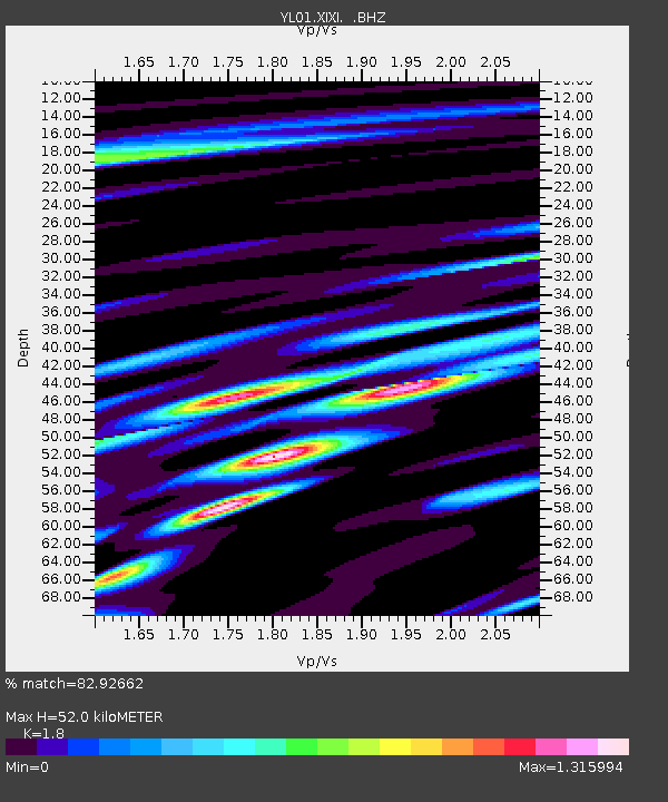
| Estimated Moho Depth: |
52.0 km |
| Estimated Crust Vp/Vs: |
1.80 |
| Assumed Crust Vp: |
6.481 km/s |
| Estimated Crust Vs: |
3.6 km/s |
| Estimated Crust Poisson's Ratio: |
0.28 |
|
| Radial Match: |
82.92662 % |
| Radial Bump: |
400 |
| Transverse Match: |
74.55231 % |
| Transverse Bump: |
400 |
| SOD ConfigId: |
16844 |
| Insert Time: |
2010-02-26 16:19:05.264 +0000 |
| GWidth: |
2.5 |
| Max Bumps: |
400 |
| Tol: |
0.001 |
|

Signal To Noise
| Channel | StoN | STA | LTA |
| YL:XIXI: :BHZ:20020802T23:18:53.739009Z | 4.700236 | 3.2634992E-7 | 6.9432666E-8 |
| YL:XIXI: :BHN:20020802T23:18:53.739009Z | 0.7470834 | 5.5180575E-8 | 7.386133E-8 |
| YL:XIXI: :BHE:20020802T23:18:53.739009Z | 1.3897959 | 9.8167284E-8 | 7.0634314E-8 |
| Arrivals |
| Ps | 6.8 SECOND |
| PpPs | 21 SECOND |
| PsPs/PpSs | 28 SECOND |


