
Station YL XIXI - YL.XIXI
Network: YL01 - Himalayan Nepal Tibet Experiment
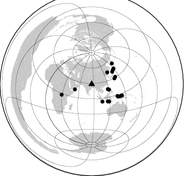
Nearby stations (2 deg radius)
| Station | Name | (Lat, Lon) | Start / End | Elevation |
| XIXI | YL.XIXI | (28.74, 85.69) | 2001-09-07 / 2003-01-01 | 4660 m |
| Crust2 Type: | R2,orogen/65km Bolivia, 0.5 km seds. |
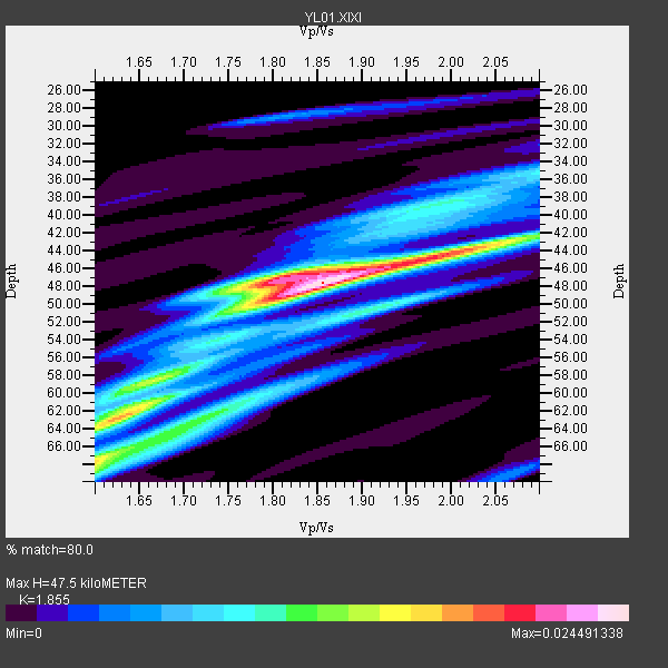
| Thickness Estimate: | 48 km |
| Thickness StdDev: | 7.4 km |
| Vp/Vs Estimate: | 1.86 |
| Vp/Vs StdDev: | 0.11 |
| Vs Estimate: | 3.494 km/s |
| Poisson's Ratio: | 0.30 |
| Peak Value: | 0.02 |
| Assumed Vp: | 6.481 km/s |
| Ps Weight: | 0.33333334 |
| PpPs Weight: | 0.33333334 |
| PsPs Weight: | 0.33333328 |
| Residual Complexity: | 0.701 |
| Nearby stations H: | +- |
| (2.0 deg) Vp/Vs: | +- |
4 with match > 90% ( 16.666666 %) and 18 with match > 80% ( 75.0 %) out of 24.
Download stack as xyz text file.
Azimuth Distribution of Events:
Prior Results for this Station
| Study | Thickness | Vp/Vs | Vp | Vs | Poissons Ratio | Extra |
| EARS | 48 km | 1.86 | 6.481 km/s | 3.494 km/s | 0.30 | |
| Crust2.0 | 65 km | 1.76 | 6.481 km/s | 3.685 km/s | 0.26 | R2,orogen/65km Bolivia, 0.5 km seds. |
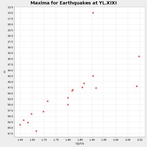
| Global Maxima | 48 km | 1.86 | 6.481 km/s | 3.494 km/s | 0.30 | amp=0.024491338 |
| Local Maxima 1 | 47 km | 1.81 | 6.481 km/s | 3.59 km/s | 0.28 | amp=0.017546844 |
| Local Maxima 2 | 68 km | 1.60 | 6.481 km/s | 4.05 km/s | 0.18 | amp=0.016271608 |
| Local Maxima 3 | 63 km | 1.62 | 6.481 km/s | 3.994 km/s | 0.19 | amp=0.013885017 |
| Local Maxima 4 | 44 km | 2.02 | 6.481 km/s | 3.212 km/s | 0.34 | amp=0.011309668 |
| Predicted Arrivals for vertical incidence (zero ray parameter) | |
| Ps | 6.27 SECOND |
| PpPs | 20.93 SECOND |
| PsPs/PpSs | 27.19 SECOND |
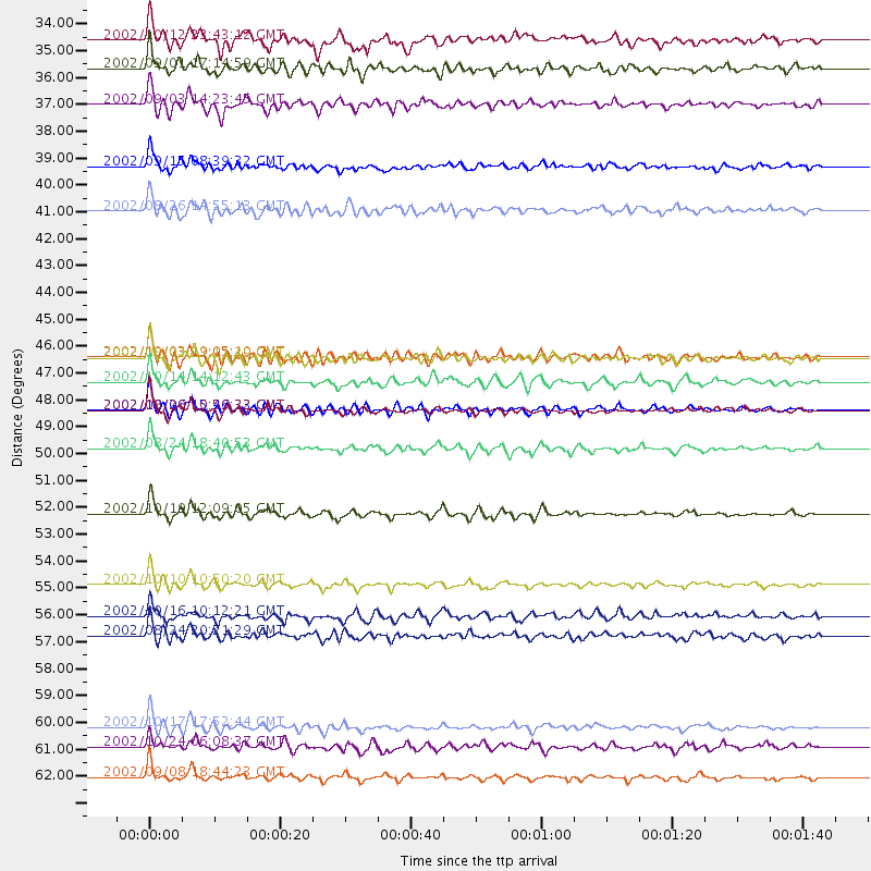
Events Processed for this Station
Download zip of receiver functions as SAC
Plot maxima for each earthquake.
Events Used in the Stack
(18 events)| Radial Match | Distance | Baz | FERegion | Time | Lat/Lon | Depth | Magnitude |
| 93.29342 | 63.5 deg | 110.177 deg | Near N Coast Of New Guinea, P.N.G. | 2002/09/08 18:44:23 GMT | (-3.3, 142.9) | 13 km | 6.5 MB, 7.8 MS, 7.6 MW, 7.3 MW |
| 93.219505 | 61.4 deg | 112.2 deg | Irian Jaya, Indonesia | 2002/10/17 17:52:44 GMT | (-3.6, 140.2) | 33 km | 5.6 MB, 6.2 MS, 6.3 MW, 6.3 MW |
| 92.95369 | 52.6 deg | 54.463 deg | Kuril Islands | 2002/10/19 12:09:05 GMT | (44.3, 150.0) | 33 km | 5.4 MB, 6.2 MS, 6.4 MW, 6.1 MW |
| 90.39487 | 48.4 deg | 134.405 deg | Sumbawa Region, Indonesia | 2002/10/06 15:46:33 GMT | (-8.2, 118.3) | 10 km | 5.8 MB, 6.0 MS, 6.2 MW, 6.2 MW |
| 89.43497 | 48.4 deg | 72.751 deg | Southeast Of Honshu, Japan | 2002/08/20 10:59:32 GMT | (31.0, 142.0) | 9.0 km | 5.4 MB, 6.2 MS, 6.3 MW, 6.1 MW |
| 89.38211 | 35.9 deg | 107.538 deg | Mindoro, Philippines | 2002/09/03 14:23:45 GMT | (13.5, 120.8) | 10 km | 5.5 MB, 5.4 MS, 5.9 MW, 5.8 MW |
| 89.337 | 46.2 deg | 136.672 deg | Bali Sea | 2002/10/03 19:05:10 GMT | (-7.5, 115.7) | 316 km | 6.0 MB, 6.0 MW, 6.0 MW |
| 89.131744 | 57.6 deg | 114.946 deg | Irian Jaya Region, Indonesia | 2002/08/24 20:21:29 GMT | (-3.3, 135.8) | 33 km | 5.5 MB, 5.5 MS, 5.8 MW, 5.7 MW |
| 87.59949 | 34.4 deg | 252.449 deg | Eastern Gulf Of Aden | 2002/09/01 17:14:59 GMT | (14.3, 51.9) | 10 km | 5.8 MS, 5.2 MB, 6.0 MW, 6.0 MW |
| 86.3868 | 38.4 deg | 53.063 deg | Northeastern China | 2002/09/15 08:39:32 GMT | (44.8, 129.9) | 586 km | 5.8 MB, 6.4 MW, 6.4 MW |
| 86.07482 | 50.0 deg | 56.281 deg | Kuril Islands | 2002/08/24 18:40:53 GMT | (43.1, 146.1) | 43 km | 5.9 MB, 5.8 MS, 6.2 MW, 6.1 MW |
| 83.981476 | 47.2 deg | 59.105 deg | Hokkaido, Japan Region | 2002/10/14 14:12:43 GMT | (41.2, 142.2) | 61 km | 5.9 MB, 6.1 MW, 6.1 MW |
| 83.64771 | 55.5 deg | 114.575 deg | Irian Jaya Region, Indonesia | 2002/10/10 10:50:20 GMT | (-1.8, 134.3) | 10 km | 6.5 MB, 7.7 MS, 7.6 MW, 7.4 MW |
| 82.92662 | 46.3 deg | 75.783 deg | Southeast Of Honshu, Japan | 2002/08/02 23:11:39 GMT | (29.3, 139.0) | 426 km | 5.5 MB, 6.3 MW, 6.3 MW |
| 82.81547 | 56.8 deg | 44.558 deg | Near East Coast Of Kamchatka | 2002/10/16 10:12:21 GMT | (52.0, 157.3) | 102 km | 6.1 MB, 6.2 MW, 6.2 MW |
| 82.79129 | 40.2 deg | 148.233 deg | Sunda Strait, Indonesia | 2002/08/26 14:55:13 GMT | (-6.8, 105.7) | 63 km | 5.6 MB, 5.8 MW, 5.7 MW |
| 82.15986 | 33.2 deg | 107.103 deg | Philippine Islands Region | 2002/10/12 23:43:12 GMT | (15.1, 118.5) | 33 km | 5.6 MB, 5.6 MS, 6.1 MW |
| 81.6915 | 62.2 deg | 250.775 deg | Lake Tanganyika Region | 2002/10/24 06:08:37 GMT | (-1.9, 29.0) | 11 km | 5.9 MB, 6.3 MS, 6.2 MW, 6.1 MW |
Losers
(6 events)| Radial Match | Distance | Baz | FERegion | Time | Lat/Lon | Depth | Magnitude | Reason |
| 78.43195 | 69.2 deg | 335.88 deg | Iceland Region | 2002/09/16 18:48:26 GMT | (66.9, -18.5) | 10 km | 5.5 MB, 5.7 MS, 5.8 MW, 5.8 MW | |
| 72.91063 | 70.5 deg | 177.875 deg | Southeast Indian Ridge | 2002/10/08 01:23:58 GMT | (-42.0, 88.4) | 10 km | 5.3 MB, 5.7 MS, 6.0 MW, 5.9 MW | |
| 72.43618 | 49.4 deg | 135.031 deg | Sumbawa Region, Indonesia | 2002/07/24 03:05:05 GMT | (-9.3, 118.6) | 29 km | 5.8 MB, 5.4 MS, 5.9 MW, 5.9 MW | |
| 66.45578 | 32.7 deg | 87.553 deg | Taiwan Region | 2002/09/16 00:03:29 GMT | (25.2, 122.3) | 183 km | 5.6 MW, 5.3 MB, 5.5 MW | |
| 56.763035 | 55.4 deg | 122.06 deg | Banda Sea | 2002/07/30 20:02:06 GMT | (-6.5, 130.3) | 103 km | 5.5 MW, 5.4 MB, 5.3 MW | |
| 55.970818 | 54.5 deg | 48.983 deg | Kuril Islands | 2002/07/17 02:20:33 GMT | (48.5, 153.3) | 148 km | 5.3 MB, 5.6 MW, 5.6 MW |
