You are here: Home > Network List > YL01 - Himalayan Nepal Tibet Experiment Stations List
> Station XIXI YL.XIXI > Earthquake Result Viewer
XIXI YL.XIXI - Earthquake Result Viewer
| Earthquake location: |
Sunda Strait, Indonesia |
| Earthquake latitude/longitude: |
-6.8/105.7 |
| Earthquake time(UTC): |
2002/08/26 (238) 14:55:13 GMT |
| Earthquake Depth: |
63 km |
| Earthquake Magnitude: |
5.6 MB, 5.8 MW, 5.7 MW |
| Earthquake Catalog/Contributor: |
WHDF/NEIC |
|
| Network: |
YL Himalayan Nepal Tibet Experiment |
| Station: |
XIXI YL.XIXI |
| Lat/Lon: |
28.74 N/85.69 E |
| Elevation: |
4660 m |
|
| Distance: |
40.2 deg |
| Az: |
332.257 deg |
| Baz: |
148.233 deg |
| Ray Param: |
0.07435144 |
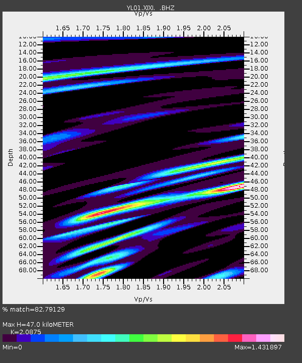
| Estimated Moho Depth: |
47.0 km |
| Estimated Crust Vp/Vs: |
2.09 |
| Assumed Crust Vp: |
6.481 km/s |
| Estimated Crust Vs: |
3.105 km/s |
| Estimated Crust Poisson's Ratio: |
0.35 |
|
| Radial Match: |
82.79129 % |
| Radial Bump: |
400 |
| Transverse Match: |
73.57535 % |
| Transverse Bump: |
400 |
| SOD ConfigId: |
16844 |
| Insert Time: |
2010-02-26 16:19:11.304 +0000 |
| GWidth: |
2.5 |
| Max Bumps: |
400 |
| Tol: |
0.001 |
|
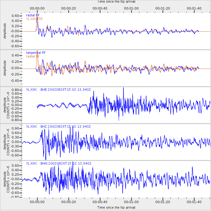
Signal To Noise
| Channel | StoN | STA | LTA |
| YL:XIXI: :BHZ:20020826T15:02:13.940Z | 6.391854 | 3.825278E-7 | 5.9846144E-8 |
| YL:XIXI: :BHN:20020826T15:02:13.940Z | 3.2136774 | 1.7301097E-7 | 5.3835826E-8 |
| YL:XIXI: :BHE:20020826T15:02:13.940Z | 3.069526 | 1.8929698E-7 | 6.166977E-8 |
| Arrivals |
| Ps | 8.4 SECOND |
| PpPs | 21 SECOND |
| PsPs/PpSs | 29 SECOND |


