You are here: Home > Network List > YL01 - Himalayan Nepal Tibet Experiment Stations List
> Station XIXI YL.XIXI > Earthquake Result Viewer
XIXI YL.XIXI - Earthquake Result Viewer
| Earthquake location: |
Bali Sea |
| Earthquake latitude/longitude: |
-7.5/115.7 |
| Earthquake time(UTC): |
2002/10/03 (276) 19:05:10 GMT |
| Earthquake Depth: |
316 km |
| Earthquake Magnitude: |
6.0 MB, 6.0 MW, 6.0 MW |
| Earthquake Catalog/Contributor: |
WHDF/NEIC |
|
| Network: |
YL Himalayan Nepal Tibet Experiment |
| Station: |
XIXI YL.XIXI |
| Lat/Lon: |
28.74 N/85.69 E |
| Elevation: |
4660 m |
|
| Distance: |
46.2 deg |
| Az: |
322.574 deg |
| Baz: |
136.672 deg |
| Ray Param: |
0.06949701 |
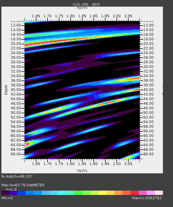
| Estimated Moho Depth: |
63.75 km |
| Estimated Crust Vp/Vs: |
1.60 |
| Assumed Crust Vp: |
6.481 km/s |
| Estimated Crust Vs: |
4.05 km/s |
| Estimated Crust Poisson's Ratio: |
0.18 |
|
| Radial Match: |
89.337 % |
| Radial Bump: |
400 |
| Transverse Match: |
81.34339 % |
| Transverse Bump: |
400 |
| SOD ConfigId: |
16844 |
| Insert Time: |
2010-02-26 16:19:16.084 +0000 |
| GWidth: |
2.5 |
| Max Bumps: |
400 |
| Tol: |
0.001 |
|

Signal To Noise
| Channel | StoN | STA | LTA |
| YL:XIXI: :BHZ:20021003T19:12:34.340013Z | 65.069534 | 2.8659356E-6 | 4.4044196E-8 |
| YL:XIXI: :BHN:20021003T19:12:34.340013Z | 12.263915 | 6.2822215E-7 | 5.1225253E-8 |
| YL:XIXI: :BHE:20021003T19:12:34.340013Z | 20.185377 | 1.1083667E-6 | 5.4909393E-8 |
| Arrivals |
| Ps | 6.3 SECOND |
| PpPs | 24 SECOND |
| PsPs/PpSs | 30 SECOND |


