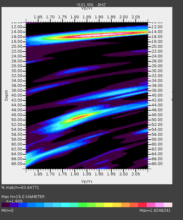
XIXI YL.XIXI - Earthquake Result Viewer

Earthquake location: Irian Jaya Region, Indonesia
Earthquake latitude/longitude: -1.8/134.3
Earthquake time(UTC): 2002/10/10 (283) 10:50:20 GMT
Earthquake Depth: 10 km
Earthquake Magnitude: 6.5 MB, 7.7 MS, 7.6 MW, 7.4 MW
Earthquake Catalog/Contributor: WHDF/NEIC
Network: YL Himalayan Nepal Tibet Experiment
Station: XIXI YL.XIXI
Lat/Lon: 28.74 N/85.69 E
Elevation: 4660 m
Distance: 55.5 deg
Az: 306.967 deg
Baz: 114.575 deg
Ray Param: 0.06472642
Estimated Moho Depth: 15.0 km
Estimated Crust Vp/Vs: 1.90
Assumed Crust Vp: 6.481 km/s
Estimated Crust Vs: 3.402 km/s
Estimated Crust Poisson's Ratio: 0.31
Radial Match: 83.64771 %
Radial Bump: 400
Transverse Match: 88.55426 %
Transverse Bump: 400
SOD ConfigId: 16844
Insert Time: 2010-02-26 16:19:17.198 +0000
GWidth: 2.5
Max Bumps: 400
Tol: 0.001

Signal To Noise

ChannelStoNSTALTA
YL:XIXI: :BHZ:20021010T10:59:24.84002Z13.6485041.6629308E-61.2183979E-7
YL:XIXI: :BHN:20021010T10:59:24.84002Z4.8108731.9978474E-74.1527752E-8
YL:XIXI: :BHE:20021010T10:59:24.84002Z10.1129778.3827734E-78.2891255E-8
Arrivals
Ps2.2 SECOND
PpPs6.4 SECOND
PsPs/PpSs8.6 SECOND