You are here: Home > Network List > YL01 - Himalayan Nepal Tibet Experiment Stations List
> Station XIXI YL.XIXI > Earthquake Result Viewer
XIXI YL.XIXI - Earthquake Result Viewer
| Earthquake location: |
Philippine Islands Region |
| Earthquake latitude/longitude: |
15.1/118.5 |
| Earthquake time(UTC): |
2002/10/12 (285) 23:43:12 GMT |
| Earthquake Depth: |
33 km |
| Earthquake Magnitude: |
5.6 MB, 5.6 MS, 6.1 MW |
| Earthquake Catalog/Contributor: |
WHDF/NEIC |
|
| Network: |
YL Himalayan Nepal Tibet Experiment |
| Station: |
XIXI YL.XIXI |
| Lat/Lon: |
28.74 N/85.69 E |
| Elevation: |
4660 m |
|
| Distance: |
33.2 deg |
| Az: |
299.665 deg |
| Baz: |
107.103 deg |
| Ray Param: |
0.07826065 |
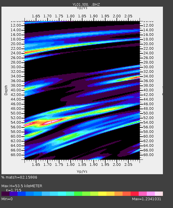
| Estimated Moho Depth: |
53.5 km |
| Estimated Crust Vp/Vs: |
1.72 |
| Assumed Crust Vp: |
6.481 km/s |
| Estimated Crust Vs: |
3.779 km/s |
| Estimated Crust Poisson's Ratio: |
0.24 |
|
| Radial Match: |
82.15986 % |
| Radial Bump: |
400 |
| Transverse Match: |
61.971447 % |
| Transverse Bump: |
400 |
| SOD ConfigId: |
16844 |
| Insert Time: |
2010-02-26 16:19:21.408 +0000 |
| GWidth: |
2.5 |
| Max Bumps: |
400 |
| Tol: |
0.001 |
|

Signal To Noise
| Channel | StoN | STA | LTA |
| YL:XIXI: :BHZ:20021012T23:49:16.261987Z | 9.693757 | 5.9478106E-7 | 6.135712E-8 |
| YL:XIXI: :BHN:20021012T23:49:16.261987Z | 1.4774328 | 1.3074695E-7 | 8.849604E-8 |
| YL:XIXI: :BHE:20021012T23:49:16.261987Z | 5.0561004 | 3.1541998E-7 | 6.238404E-8 |
| Arrivals |
| Ps | 6.4 SECOND |
| PpPs | 21 SECOND |
| PsPs/PpSs | 27 SECOND |


