You are here: Home > Network List > YL01 - Himalayan Nepal Tibet Experiment Stations List
> Station XIXI YL.XIXI > Earthquake Result Viewer
XIXI YL.XIXI - Earthquake Result Viewer
| Earthquake location: |
Hokkaido, Japan Region |
| Earthquake latitude/longitude: |
41.2/142.2 |
| Earthquake time(UTC): |
2002/10/14 (287) 14:12:43 GMT |
| Earthquake Depth: |
61 km |
| Earthquake Magnitude: |
5.9 MB, 6.1 MW, 6.1 MW |
| Earthquake Catalog/Contributor: |
WHDF/NEIC |
|
| Network: |
YL Himalayan Nepal Tibet Experiment |
| Station: |
XIXI YL.XIXI |
| Lat/Lon: |
28.74 N/85.69 E |
| Elevation: |
4660 m |
|
| Distance: |
47.2 deg |
| Az: |
273.415 deg |
| Baz: |
59.105 deg |
| Ray Param: |
0.06994578 |
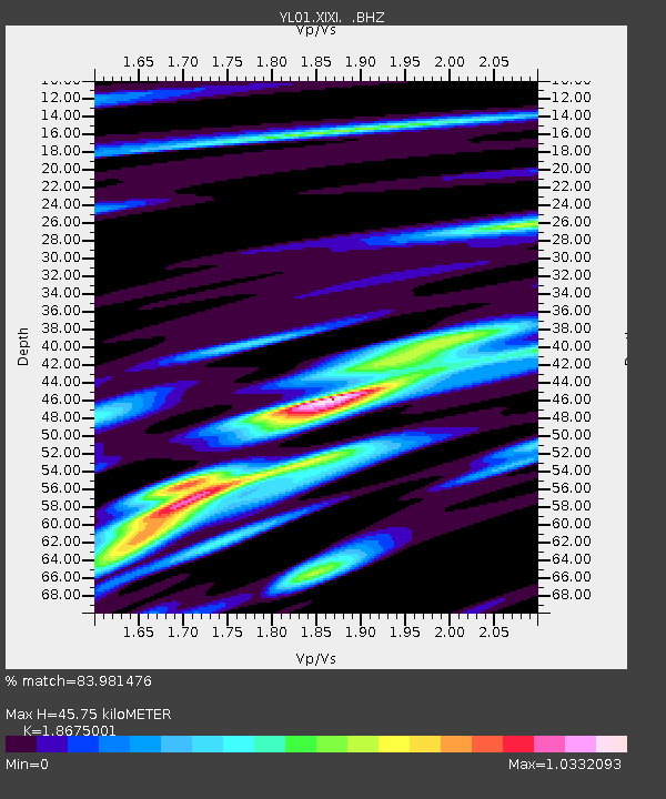
| Estimated Moho Depth: |
45.75 km |
| Estimated Crust Vp/Vs: |
1.87 |
| Assumed Crust Vp: |
6.481 km/s |
| Estimated Crust Vs: |
3.47 km/s |
| Estimated Crust Poisson's Ratio: |
0.30 |
|
| Radial Match: |
83.981476 % |
| Radial Bump: |
400 |
| Transverse Match: |
74.6851 % |
| Transverse Bump: |
400 |
| SOD ConfigId: |
16844 |
| Insert Time: |
2010-02-26 16:19:23.594 +0000 |
| GWidth: |
2.5 |
| Max Bumps: |
400 |
| Tol: |
0.001 |
|

Signal To Noise
| Channel | StoN | STA | LTA |
| YL:XIXI: :BHZ:20021014T14:20:40.088989Z | 17.848194 | 1.4695712E-6 | 8.233725E-8 |
| YL:XIXI: :BHN:20021014T14:20:40.088989Z | 5.5673065 | 4.7463524E-7 | 8.5254015E-8 |
| YL:XIXI: :BHE:20021014T14:20:40.088989Z | 6.127145 | 5.64935E-7 | 9.2202E-8 |
| Arrivals |
| Ps | 6.5 SECOND |
| PpPs | 19 SECOND |
| PsPs/PpSs | 26 SECOND |


