You are here: Home > Network List > YL01 - Himalayan Nepal Tibet Experiment Stations List
> Station XIXI YL.XIXI > Earthquake Result Viewer
XIXI YL.XIXI - Earthquake Result Viewer
| Earthquake location: |
Near East Coast Of Kamchatka |
| Earthquake latitude/longitude: |
52.0/157.3 |
| Earthquake time(UTC): |
2002/10/16 (289) 10:12:21 GMT |
| Earthquake Depth: |
102 km |
| Earthquake Magnitude: |
6.1 MB, 6.2 MW, 6.2 MW |
| Earthquake Catalog/Contributor: |
WHDF/NEIC |
|
| Network: |
YL Himalayan Nepal Tibet Experiment |
| Station: |
XIXI YL.XIXI |
| Lat/Lon: |
28.74 N/85.69 E |
| Elevation: |
4660 m |
|
| Distance: |
56.8 deg |
| Az: |
275.395 deg |
| Baz: |
44.558 deg |
| Ray Param: |
0.06357483 |
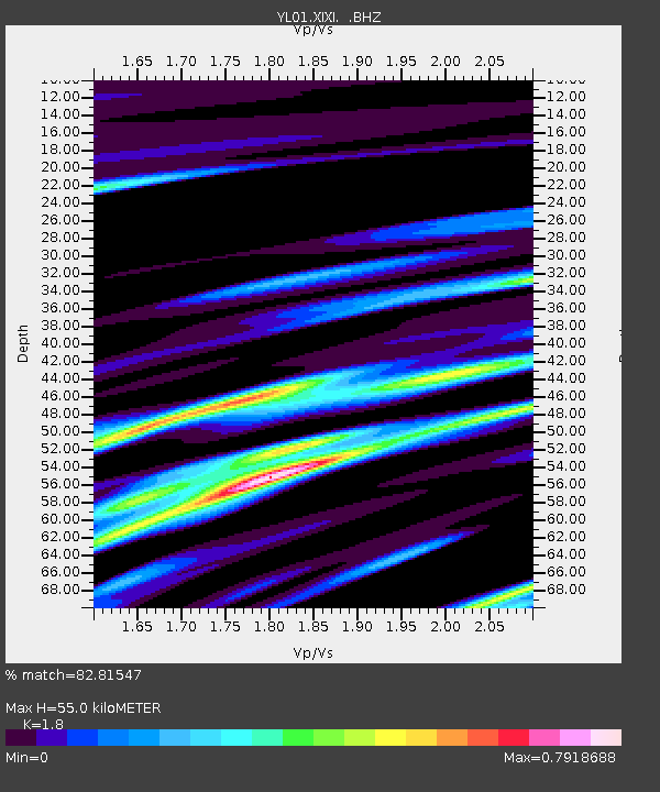
| Estimated Moho Depth: |
55.0 km |
| Estimated Crust Vp/Vs: |
1.80 |
| Assumed Crust Vp: |
6.481 km/s |
| Estimated Crust Vs: |
3.6 km/s |
| Estimated Crust Poisson's Ratio: |
0.28 |
|
| Radial Match: |
82.81547 % |
| Radial Bump: |
400 |
| Transverse Match: |
84.901405 % |
| Transverse Bump: |
400 |
| SOD ConfigId: |
16844 |
| Insert Time: |
2010-02-26 16:19:24.419 +0000 |
| GWidth: |
2.5 |
| Max Bumps: |
400 |
| Tol: |
0.001 |
|

Signal To Noise
| Channel | StoN | STA | LTA |
| YL:XIXI: :BHZ:20021016T10:21:24.664009Z | 35.242805 | 1.660006E-6 | 4.7101985E-8 |
| YL:XIXI: :BHN:20021016T10:21:24.664009Z | 10.260402 | 4.7187714E-7 | 4.5990124E-8 |
| YL:XIXI: :BHE:20021016T10:21:24.664009Z | 13.99946 | 5.500897E-7 | 3.9293635E-8 |
| Arrivals |
| Ps | 7.1 SECOND |
| PpPs | 23 SECOND |
| PsPs/PpSs | 30 SECOND |


