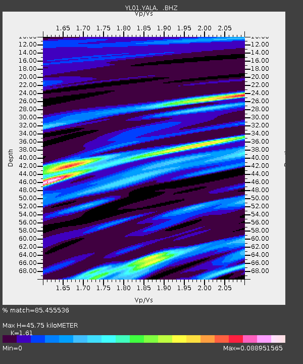
YALA YL.YALA - Earthquake Result Viewer
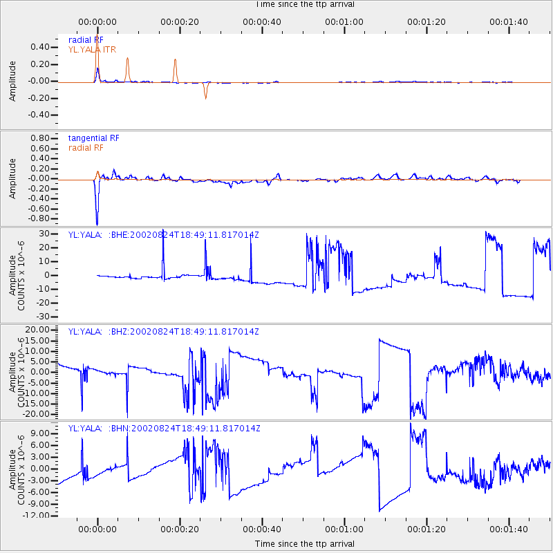
Earthquake location: Kuril Islands
Earthquake latitude/longitude: 43.1/146.1
Earthquake time(UTC): 2002/08/24 (236) 18:40:53 GMT
Earthquake Depth: 43 km
Earthquake Magnitude: 5.9 MB, 5.8 MS, 6.2 MW, 6.1 MW
Earthquake Catalog/Contributor: WHDF/NEIC
Network: YL Himalayan Nepal Tibet Experiment
Station: YALA YL.YALA
Lat/Lon: 28.40 N/86.11 E
Elevation: 4434 m
Distance: 49.9 deg
Az: 273.499 deg
Baz: 56.073 deg
Ray Param: 0.06834047
Estimated Moho Depth: 45.75 km
Estimated Crust Vp/Vs: 1.61
Assumed Crust Vp: 6.514 km/s
Estimated Crust Vs: 4.046 km/s
Estimated Crust Poisson's Ratio: 0.19
Radial Match: 85.455536 %
Radial Bump: 353
Transverse Match: 84.206245 %
Transverse Bump: 377
SOD ConfigId: 16820
Insert Time: 2010-02-26 16:19:47.950 +0000
GWidth: 2.5
Max Bumps: 400
Tol: 0.001

Signal To Noise

ChannelStoNSTALTA
YL:YALA: :BHZ:20020824T18:49:11.817014Z0.319071561.6076649E-65.0385715E-6
YL:YALA: :BHN:20020824T18:49:11.817014Z0.293847981.1846134E-64.0313816E-6
YL:YALA: :BHE:20020824T18:49:11.817014Z0.506874561.8536313E-63.6569822E-6
Arrivals
Ps4.6 SECOND
PpPs17 SECOND
PsPs/PpSs22 SECOND