
Station YL YALA - YL.YALA
Network: YL01 - Himalayan Nepal Tibet Experiment
Nearby stations (2 deg radius)
| Station | Name | (Lat, Lon) | Start / End | Elevation |
| YALA | YL.YALA | (28.40, 86.11) | 2001-09-07 / 2003-01-01 | 4434 m |
| Crust2 Type: | RD,orogen/70km Tibet, no seds. |
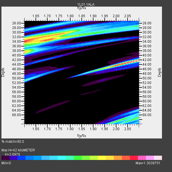
| Thickness Estimate: | 42 km |
| Thickness StdDev: | 11 km |
| Vp/Vs Estimate: | 2.10 |
| Vp/Vs StdDev: | 0.18 |
| Vs Estimate: | 3.106 km/s |
| Poisson's Ratio: | 0.35 |
| Peak Value: | 1.30 |
| Assumed Vp: | 6.514 km/s |
| Ps Weight: | 0.33333334 |
| PpPs Weight: | 0.33333334 |
| PsPs Weight: | 0.33333328 |
| Residual Complexity: | 0.937 |
| Nearby stations H: | +- |
| (2.0 deg) Vp/Vs: | +- |
5 with match > 90% ( 33.333332 %) and 6 with match > 80% ( 40.0 %) out of 15.
Download stack as xyz text file.
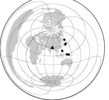
Azimuth Distribution of Events:
Prior Results for this Station
| Study | Thickness | Vp/Vs | Vp | Vs | Poissons Ratio | Extra |
| EARS | 42 km | 2.10 | 6.514 km/s | 3.106 km/s | 0.35 | |
| Crust2.0 | 70 km | 1.76 | 6.514 km/s | 3.706 km/s | 0.26 | RD,orogen/70km Tibet, no seds. |
| Global Maxima | 42 km | 2.10 | 6.514 km/s | 3.106 km/s | 0.35 | amp=1.3039751 |
| Local Maxima 1 | 34 km | 1.60 | 6.514 km/s | 4.071 km/s | 0.18 | amp=1.062617 |
| Local Maxima 2 | 38 km | 1.60 | 6.514 km/s | 4.071 km/s | 0.18 | amp=0.9138661 |
| Local Maxima 3 | 30 km | 1.78 | 6.514 km/s | 3.665 km/s | 0.27 | amp=0.7715162 |
| Local Maxima 4 | 69 km | 1.99 | 6.514 km/s | 3.278 km/s | 0.33 | amp=0.72030574 |
| Predicted Arrivals for vertical incidence (zero ray parameter) | |
| Ps | 7.08 SECOND |
| PpPs | 19.97 SECOND |
| PsPs/PpSs | 27.05 SECOND |
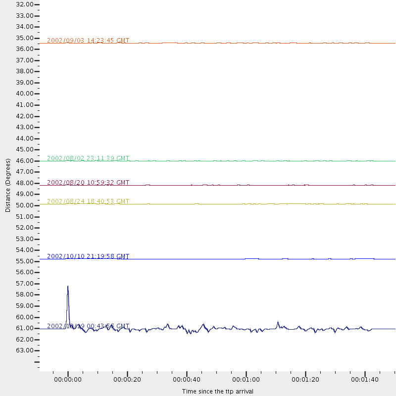
Events Processed for this Station
Download zip of receiver functions as SAC
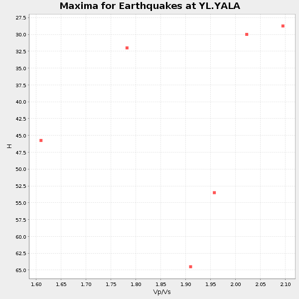
Plot maxima for each earthquake.
Events Used in the Stack
(6 events)| Radial Match | Distance | Baz | FERegion | Time | Lat/Lon | Depth | Magnitude |
| 99.295204 | 48.2 deg | 72.568 deg | Southeast Of Honshu, Japan | 2002/08/20 10:59:32 GMT | (31.0, 142.0) | 9.0 km | 5.4 MB, 6.2 MS, 6.3 MW, 6.1 MW |
| 97.926216 | 46.0 deg | 75.583 deg | Southeast Of Honshu, Japan | 2002/08/02 23:11:39 GMT | (29.3, 139.0) | 426 km | 5.5 MB, 6.3 MW, 6.3 MW |
| 93.23714 | 54.7 deg | 114.537 deg | Irian Jaya Region, Indonesia | 2002/10/10 21:19:58 GMT | (-1.5, 134.1) | 10 km | 5.8 MB, 5.7 MS, 6.0 MW |
| 92.36846 | 35.4 deg | 107.449 deg | Mindoro, Philippines | 2002/09/03 14:23:45 GMT | (13.5, 120.8) | 10 km | 5.5 MB, 5.4 MS, 5.9 MW, 5.8 MW |
| 90.968864 | 61.0 deg | 112.316 deg | Irian Jaya, Indonesia | 2002/10/19 00:43:56 GMT | (-3.7, 140.3) | 33 km | 5.3 MB, 5.9 MS, 6.1 MW, 6.0 MW |
| 85.455536 | 49.9 deg | 56.073 deg | Kuril Islands | 2002/08/24 18:40:53 GMT | (43.1, 146.1) | 43 km | 5.9 MB, 5.8 MS, 6.2 MW, 6.1 MW |
Losers
(9 events)| Radial Match | Distance | Baz | FERegion | Time | Lat/Lon | Depth | Magnitude | Reason |
| 99.56537 | 58.3 deg | 303.56 deg | Southern Italy | 2002/11/01 15:09:00 GMT | (41.7, 14.9) | 10 km | 5.5 MB, 5.6 MS, 5.8 MW, 5.7 MW | |
| 76.98374 | 56.8 deg | 44.432 deg | Near East Coast Of Kamchatka | 2002/10/16 10:12:21 GMT | (52.0, 157.3) | 102 km | 6.1 MB, 6.2 MW, 6.2 MW | |
| 75.37999 | 82.2 deg | 106.5 deg | Solomon Islands | 2002/09/24 23:01:28 GMT | (-10.6, 161.2) | 19 km | 5.7 MB, 6.5 MS, 6.3 MW, 6.3 MW | |
| 73.63923 | 82.3 deg | 106.749 deg | Solomon Islands | 2002/10/01 08:46:55 GMT | (-10.9, 161.2) | 10 km | 5.7 MB, 5.5 MS, 5.8 MW, 5.6 MW | |
| 69.80011 | 47.9 deg | 134.626 deg | Sumbawa Region, Indonesia | 2002/10/06 15:46:33 GMT | (-8.2, 118.3) | 10 km | 5.8 MB, 6.0 MS, 6.2 MW, 6.2 MW | |
| 68.33593 | 47.1 deg | 58.862 deg | Hokkaido, Japan Region | 2002/10/14 14:12:43 GMT | (41.2, 142.2) | 61 km | 5.9 MB, 6.1 MW, 6.1 MW | |
| 58.48239 | 93.0 deg | 109.545 deg | Vanuatu Islands | 2002/10/07 19:00:31 GMT | (-18.7, 169.3) | 246 km | 5.4 MB, 5.7 MW, 5.6 MW | |
| 52.685863 | 69.7 deg | 336.005 deg | Iceland Region | 2002/09/16 18:48:26 GMT | (66.9, -18.5) | 10 km | 5.5 MB, 5.7 MS, 5.8 MW, 5.8 MW | |
| 51.372623 | 63.0 deg | 110.285 deg | Near N Coast Of New Guinea, P.N.G. | 2002/09/08 18:44:23 GMT | (-3.3, 142.9) | 13 km | 6.5 MB, 7.8 MS, 7.6 MW, 7.3 MW |
